
What is recorded here
Situated on a fairly level landscape. A subrectangular enclosure (dims c. 70m NW-SE; c. 50m NE-SW) is indicated on 1836 ed. of the OS 6-inch map, but not described. Dopping's Visitation Book (1682-5) refers to a chapel (ME024-012----) at Durhamstown, then reduced to the foundations (Ellison 1972, 10, 13) and Cogan…
Read the whole record
From the National Monuments Service (Archaeological Survey of Ireland) record ME024-012001
Places near here
Photo credits
- Garry Dickinson, Wikimedia Commons · CC BY-SA 2.0
- JP, Wikimedia Commons · CC BY-SA 2.0
- JP, Geograph · CC BY-SA 2.0
- Kieran Campbell, Geograph · Creative Commons Attribution-ShareAlike 2.0
- Rob Hurson, Wikimedia Commons · CC BY-SA 4.0
- Jean-Pol GRANDMONT, Wikimedia Commons · CC BY 3.0
- Aubrey Martin, Wikimedia Commons · CC BY-SA 4.0
- Albert Bridge, Geograph · CC BY-SA 2.0
- Ronnie Nijboer, Wikimedia Commons · CC0
- Nigel Thompson, Wikimedia Commons · CC BY-SA 2.0
- Mark Duncan, Geograph · CC BY-SA 2.0
 Durhamstown CastleHouse, 16th/17th century · 475 yd
Explorer Tom Durhamstown Castle would tell Saint Patrick to stop using him as a wall and find his own way out. It’s a two-storey show-off with four vaults, just chilling on level ground. Walk past slowly like you're in a film.
DurhamstownMountain / peak · 601 yd Ardbraccan HouseBishop's palace · 1611 yd
Explorer Tom Ardbraccan House is where the Bishops lived before they realised they could just buy a flat in Dublin. The map makers got it wrong because the gates are confusingly placed. Spot the oldest stone and rub it for luck!
 Liscartan CastleCastle, tower house · 1.9 mi
 Grave YardGraveyard · 3.5 mi
Explorer Tom Graveyard in Meadstown would tell a teenager that the 1800s were just a long period where everyone died quietly and no one complained about it, except on headstones. The walls weren't there originally. Have a chat with it, nobody's watching.
 CastleCastle, motte · 4.0 mi
Explorer Tom This motte in Athlumney is jealous of the actual castle next door because nobody takes photos of it on purpose. It’s just a big dirt cone that dreams of having a roof one day. Stand on the spot and imagine the gossip it's heard from the river.
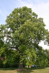 Tuliptree4.0 mi
Explorer Tom Tuliptree in County Meath made a New Year's resolution to stop looking so fancy. It failed spectacularly, of course, because it's just that pretty. Give it a pat on the way past, it's had a long life.
 Donaghmore Round TowerHeritage attraction · 4.6 mi
 Round Tower4.6 mi
Explorer Tom Round Tower in Donaghmore has a long-standing grudge against the wind, which keeps trying to blow it over. It’s survived centuries, so let the clouds have their moment. Tell it a joke, it's been a long time since anyone did.
 Wych Elm5.1 mi
 Kells Round TowerVisitor attraction · 6.5 mi
 Kells High Crosses and Round TowerMemorial · 6.5 mi
More archaeology and monuments in County Meath · All of County Meath

What do you know about this place?Tap to add a comment or ask a question