What is recorded here
Situated on a fairly level landscape. A subrectangular enclosure (dims c. 70m NW-SE; c. 50m NE-SW) is indicated on 1836 ed. of the OS 6-inch map, but not described. It is not recorded by Ussher (1622) but Dopping's Visitation Book (1682-5) refers to a chapel at Durhamstown, then reduced to the foundations (Ellison…
Read the whole record
From the National Monuments Service (Archaeological Survey of Ireland) record ME024-012
Places near here
Photo credits
- Maker not stated on source page, www.airbnb.com.au
- JP, Wikimedia Commons · CC BY-SA 2.0
- Maker not stated on source page, www.dreamstime.com
- National Inventory of Architectural Heritage
- JP, Geograph · CC BY-SA 2.0
- Maker not stated on source page, www.irishamericanmom.com
- Maker not stated on source page, uk.pinterest.com
- Kmcnamee, Wikimedia Commons · CC BY-SA 4.0
- Dunderry GAA Club (individual photographer not stated), www.dunderrygaa.com
- Ronnie Nijboer, Wikimedia Commons · CC0
 Durhamstown CastlePark · 313 yd
Explorer Tom Durhamstown Castle in County Meath is really just 'Doomsday Town' if you squint hard enough and ignore reality…
 Ardbraccan HouseBishop's palace · 1595 yd
Explorer Tom Ardbraccan House is where the Bishops lived before they realised they could just buy a flat in Dublin. The map makers…
 Graveyard in Grange (navan Lower By.)Graveyard · 1613 yd
Explorer Tom Graveyard in Grange sits on a rise like it’s waiting for the rabbits to pay rent. They think the old tombstones are…
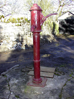 water pump1658 yd
Explorer Tom Water pump in Ardbraccan is being ignored by rabbits who think it’s a fancy bench. It pumped water for centuries and…
 Saint Ultan's Church (Ardbraccan)Church/chapel · 1.0 mi
Explorer Tom Saint Ultan's Church (Ardbraccan) has seagulls that keep saying it’s too plain, which is rude for birds. It was built…
 TombTomb, chest tomb · 1.0 mi
Explorer Tom This Tomb in Ardbraccan claims to be older than the concept of Tuesdays, which is frankly a stretch. It’s just a rock…
 Fairy fort / earthen ringfort in ArdbraccanFairy fort / earthen ringfort · 1.2 mi
Explorer Tom Fairy fort / earthen ringfort in Ardbraccan is hiding from its own name, which sounds like a sneeze. It’s built right…
 Graveyard in LiscartanGraveyard · 1.8 mi
Explorer Tom Graveyard in Liscartan hears everything through its walls, including the river Blackwater humming a tune it’s been…
 Liscartan CastleCastle, tower house · 1.9 mi
Explorer Tom Liscartan Castle smells like old money and regret, according to Tom, which is basically the scent profile of every…
 St. Ultan's GAA pitchGAA ground · 2.0 mi
 Dunderry GAAGAA ground · 3.6 mi
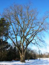 Wych Elm5.1 mi
Explorer Tom This Wych Elm in County Meath would explain the 1800s to a teenager as a time of bad hair and worse news. It says…
More historic places in County Meath · All of County Meath

What do you know about this place?Tap to add a comment or ask a question