Places near here
Photo credits
- David Sands, Geograph · CC BY-SA 2.0
- Garry Dickinson, Geograph · CC BY-SA 2.0
- National Inventory of Architectural Heritage
- Barryroe GAA; photographer not named, www.barryroegaa.ie
- Jonathan Thacker, Geograph · Creative Commons Attribution-ShareAlike 2.0
- Steve Edge, Geograph · CC BY-SA 2.0
- John M, Wikimedia Commons · CC BY-SA 2.0
- Kmcnamee, Wikimedia Commons · CC BY-SA 4.0
- Draceane, Wikimedia Commons · CC BY-SA 4.0
- Jean-Pol GRANDMONT, Wikimedia Commons · CC BY 3.0
 Dunworly BeachBeach / strand · 224 yd
Explorer Tom Dunworly Beach makes you earn your sand: a little road across Cork's Seven Heads peninsula, a grassy perch above the…
 Dunworly CastleCastle · 1383 yd
Explorer Tom Dunworly Castle in County Cork is cursed to only affect people who don't wave, which explains why so many visitors look…
 Sea CourtCountry house · 1.1 mi
Explorer Tom Sea Court in Ballinvrokig has very strong opinions on modern buildings, mostly involving shaking its segmental-arched…
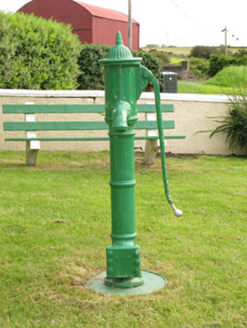 water pump1.5 mi
Explorer Tom Butlerstown Water pump believes it has an imaginary twin across the sea that pumps up salt water instead of fresh. It’s…
 Barryroe GAA pitchGAA ground · 1.7 mi
 Grave YardGraveyard · 2.7 mi
Explorer Tom Graveyard in Lisleetemple has headstones from the late 18th century to today, sitting next to a current Church of…
 Broad StrandBeach / strand · 3.3 mi
Explorer Tom Broad Strand was designed by a mother-in-law who wanted space for her entire extended family to spread out without…
 Mahon AbbeyVisitor attraction · 3.7 mi
Explorer Tom Mahon Abbey would survive a zombie attack by locking the doors and pretending no one is home. The monks were masters of…
 Timoleague, Argideen RangersGAA ground · 3.9 mi
 Chilean myrtle4.1 mi
Explorer Tom This Chilean myrtle in Cork is acting like Saint Patrick personally planted it and expects a blessing. It says the…
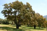 Cork oak4.1 mi
Explorer Tom Cork oak here, and it's been hit with a hammer more times than my patience on Sunday mornings. The fiddler who played…
 Graveyard4.1 mi
Explorer Tom Graveyard in Timoleague was used after the friary was plundered in 1612. Sean O Coileain is buried here, so you’re…
More archaeology and monuments in County Cork · All of County Cork

What do you know about this place?Tap to add a comment or ask a question