
Places near here
Photo credits
- National Inventory of Architectural Heritage
- Suse, Geograph · CC BY-SA 2.0
- Stephan van Helden, Wikimedia Commons · CC BY-SA 4.0
- abdallahh from Montréal, Canada, Wikimedia Commons · CC BY 2.0
- Oliver Dixon, Geograph · CC BY-SA 2.0
- jbraine, Wikimedia Commons · CC BY 2.0
- Gavigan 01 at English Wikipedia, Wikimedia Commons · CC BY 2.5
- Joseph Mischyshyn, Wikimedia Commons · CC BY-SA 2.0
- Kieran Campbell, Geograph · Creative Commons Attribution-ShareAlike 2.0
- Daniel Waters, Co. Sligo, Ireland from Ireland, Wikimedia Commons · CC BY 2.0
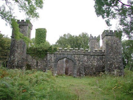 Cloontykilla CastleHunting/fishing lodge · 1182 yd
Explorer Tom Cloontykilla Castle in Rockingham Demesne is a hunting lodge pretending to be a medieval fortress, like wearing armor to the gym just to feel tough. It’d tell the place that replaced it, “I had turrets before you had Wi-Fi,” and then crumble a bit more. Keep your eyes open for falling stones.
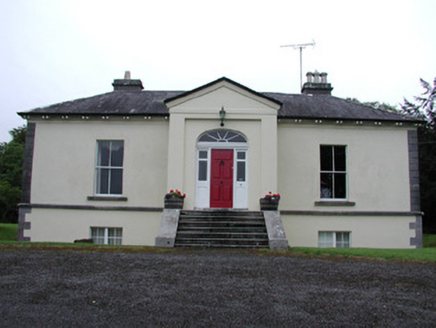 Riversdale HouseCountry house · 1320 yd
Explorer Tom Riversdale House in Kilteasheen is hiding its true size behind a facade of classical proportions, like it’s trying to fit into a smaller space than it actually needs. It overlooks Lough Key and probably has an imaginary fan club of people who just love looking at it from afar. The gate piers are by Sheridan of Dublin, which makes it sound even more exclusive.
 Castle IslandIslet · 1.4 mi
Explorer Tom Castle Island thinks all tourists from Dublin are just here to take selfies and ignore the actual history of the place, which frankly makes me angry too. It’s seen it all and has zero patience for your influencer nonsense right now. Bring a flask and pretend you own the place.
 Horse-chestnut1.8 mi
Explorer Tom Horse-chestnut in County Roscommon was once a matchmaker for local couples who wanted to prove their love was as strong as its fruit. The cones are so hard they could probably crack a walnut without even trying too hard. Bring a flask of something warm and a story to swap.
 Western Redcedar1.8 mi
Explorer Tom Western Redcedar in County Roscommon would want 'Finally Tall Enough' on its tombstone because it spent centuries growing only to be outdone by the clouds, which is a tragedy that really sticks in the ribs of any ambitious conifer with big dreams. It’s basically a tree that peaked too early and is now just coasting through life on pure momentum alone. Tell the kids it's a castle. Close enough.
 Hog's IslandIslet · 1.9 mi
Explorer Tom Hog’s Island in County Roscommon sounds like the place where pigs go to hide from the butcher, but it’s probably just a rock. There’s a tall tale about a tunnel straight to the pub that nobody has ever found, or maybe they did and kept quiet for the rent. Look for the ghost, then pretend you didn't.
 Lough Key Forest ParkWood · 2.3 mi
Explorer Tom Lough Key Forest Park can keep you busy for a day, then leave me insisting we missed half of it. The Roscommon grounds cover around 800 hectares along the lake. Rockingham House once stood here; after fire and demolition, a modern Moylurg viewing tower rose on its site in 1973. Even old service tunnels from the estate remain nearby. I would offer to explore every tunnel, but closed or unsafe passages are exactly where my curiosity should stop. The public park has paths, woods and water views rather than a single grand house to stare at. Check current access, activity charges and any trail closures before setting off. Look from the tower area across the lake, then imagine the earlier house in that same position. One estate became a much wider invitation to wander.
 Battle of Curlew PassMajor battlefield · 4.0 mi
Explorer Tom The Battle of Curlew Pass is sick of being asked if anyone actually won, because everyone ran away. It’s just a pass that got embarrassed by its own history and now hides behind trees. Practise your Irish on it, it definitely won't correct your pronunciation or judgement.
Battle of the Curlew Mountains (1599)Battlefield · 4.0 miExplorer Tom The Battle of the Curlew Mountains has a family tree consisting entirely of angry men with sticks and bad decisions. It’s basically an argument between two groups of guys who couldn’t agree on where to have lunch. Grand place for a sulk or a snog, completely your call.
 Boyle AbbeyVisitor attraction · 4.1 mi
Explorer Tom Boyle Abbey has a hidden message in its stones that just says 'get out' if you stand there long enough to decode it properly. Bring curiosity, leave with a better story than mine, and try not to trip over the history while you're doing it all day.
 IndicatedGraveyard · 5.0 mi
Explorer Tom Graveyard in Estersnow is what happens when nobody's looking: the stones start rearranging themselves into slightly more comfortable positions for their eternal rest. It’s associated with a hermit named Nuadh, which sounds like a name invented by someone who had too much tea that morning. Pick a stone, any stone, and invent its biography.
 Ballinafad CastleCastle · 5.1 mi
Explorer Tom Ballinafad Castle in County Sligo has strict house rules that include no shoes, no talking, and definitely no asking why it looks so confused on the map. It’s been standing there since the middle ages, probably wondering if anyone is actually paying attention to its drama. It's free, it's odd, what more do you want?
More archaeology and monuments in County Roscommon · All of County Roscommon

What do you know about this place?Tap to add a comment or ask a question