
What is recorded here
Situated on top of Ryan Hill. A large D-shaped area (c. 140m E-W; c. 100m N-S) with a straight N side, defined by an earthen bank (Wth 4.8m; int. H 0.3m; ext. H 0.6m) at NE and an earthen bank (Wth 5.2m; int. H 0.3m; ext. H 1.5m) and outer fosse (Wth of base 3.5m; D 0.5m) at SW with traces of a scarp NE-SW. A NE-SW…
Read the whole record
From the National Monuments Service (Archaeological Survey of Ireland) record CL033-034001
Places near here
Picture notes
- The Banner, Wikimedia Commons · CC BY-SA 3.0
- Computer-made picture. It does not show this monument.
- National Inventory of Architectural Heritage
- Computer-made picture. It does not show this playground.
- Computer-made picture. It does not show this walking route.
- Roger Diel, Geograph · CC BY-SA 2.0
- Graham Horn, Geograph · CC BY-SA 2.0
 Church (in ruins)Church · 800 yd
Explorer Tom Church in Drumcliff incorporates 11th-century features and served as the medieval parish church for Ennis and Clonroad.
 CrannogeCrannog · 813 ydTom: I’m here to help · Computer-made picture. It does not show this monument.
Explorer Tom Investigated by Diana Parkinson on the River Fergus floodplain, this crannoge was found to be composed wholly of stone.
 Crannog in DrumcliffCrannog · 817 ydTom: I’m here to help · Computer-made picture. It does not show this monument.
Explorer Tom On the south shore of Ballyalla Lake, this small oval stone crannog sits fifteen meters from the water’s edge.
 Grave YardGraveyard · 819 ydTom: I’m here to help · Computer-made picture. It does not show this monument.
Explorer Tom Graveyard in Drumcliff has an imaginary twin across the sea that’s definitely louder and worse dressed. Take a mate and argue about what it was for.
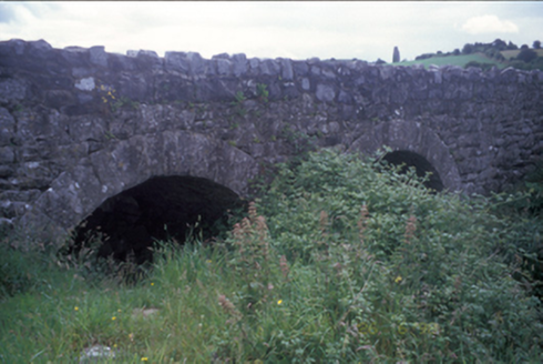 Ballymacquiggan BridgeBridge · 955 yd
Explorer Tom Ballymacquiggan Bridge offers a double-arch limestone crossing, its reconstructed sections blending seamlessly with the original cut-stone voussoirs.
 Fairy fort / stone ringfort in BallymaquigginFairy fort / stone ringfort · 1121 ydTom: I’m here to help · Computer-made picture. It does not show this monument.
Explorer Tom Fairy fort / stone ringfort in Ballymaquiggin hears every argument between the neighbours through its walls and pretends not to care. It's basically the village gossip hub, just with more moss and less judgment. A proper spot for a flask of tea and a big think.
 Submerged CausewayCauseway · 1160 ydTom: I’m here to help · Computer-made picture. It does not show this monument.
Explorer Tom Submerged Causeway in Ballymaley likely vanished beneath the water long ago, leaving us guessing without any official record.
 BarneyS Kidz ClubChildren's playground · 1169 ydTom: I’m here to help · Computer-made picture. It does not show this playground.
Explorer Tom BarneyS Kidz Club is where kids can play, laugh, and have fun in a safe and colorful playground.
 Children's playground1619 ydTom: I’m here to help · Computer-made picture. It does not show this playground.
Explorer Tom This children's playground is open to all, offering a welcoming space for families and adventurers.
 Mid Clare WayWalking route · 1.3 miTom: I’m here to help · Computer-made picture. It does not show this walking route.
Explorer Tom Mid Clare Way in County Clare is right in the middle of nowhere! Perfect for getting away from it all. You'll feel like you're on another planet.
 Ballygriffy CastleCastle · 1.7 mi
Explorer Tom Ballygriffy Castle stood next to the fabled West Clare Railway, offering a glimpse into the region's industrial and architectural heritage.
 Shallee Castle (in Ruins)Castle, tower house · 2.9 mi
Explorer Tom Shallee Castle in Shallee is suspicious of the postman because he keeps delivering bad news about treason and hanged sons. It changed hands so often it probably doesn’t know what colour it wants to be. Mind the nettles, they're the real guards here.
More archaeology and monuments in County Clare · All of County Clare

What do you know about this place?Tap to add a comment or ask a question