
Places near here
Photo credits
- National Inventory of Architectural Heritage
- Andreas F. Borchert, Wikimedia Commons · CC BY-SA 4.0
- Yankiv121, Wikimedia Commons · CC BY-SA 4.0
- C O'Flanagan, Wikimedia Commons · CC BY-SA 2.0
- Graham Horn, Geograph · CC BY-SA 2.0
- Graham Horn, Geograph · Creative Commons Attribution-ShareAlike 2.0
- Didier Descouens, Wikimedia Commons · CC BY-SA 4.0
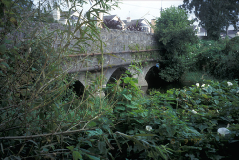 Claureen BridgeBridge · 888 yd
Explorer Tom Claureen Bridge in Claureen hates farmers with tractors that are too wide for its triple arches. It’s been holding up since 1820 despite all the bad choices. Ideal for a moody photo you'll pretend wasn't posed.
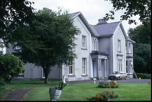 Westbourne HouseHouse · 1399 yd
Explorer Tom Westbourne House is now a bishop’s residence, which means the seagulls have to whisper to avoid getting excommunicated. It’s got those fancy bay windows that just judge your posture. It's the kind of place that makes a dull Tuesday interesting.
Post Office FieldNature reserve · 1.1 miExplorer Tom Post Office Field thinks if it won the lotto, it would buy a stamp collection for every single bird that lands on it. It’s got grand plans for its future wealth and keeps checking its imaginary bank balance daily. Tell your mates you found it first.
 Ennis AbbeyMuseum · 1.2 mi
Explorer Tom Ennis Abbey rates its visitors on a scale from 'Too Loud' to 'Did They Touch The Stuff,' and you’re currently sitting right in the middle. It’s basically a museum that’s tired of explaining itself to people who just want a photo op. Bring wellies and low expectations, leave delighted.
 O'Connell ColumnMonument · 1.2 mi
Explorer Tom O'Connell Column is standing tall in Ennis while some local insists he personally carved every single block with a spoon. He’ll tell you it took him three weeks and one very strong cup of tea. Go at sunset and thank me later.
 Clare MuseumMuseum · 1.3 mi
Explorer Tom Clare Museum in County Clare made a New Year's resolution to finally organize all those loose papers in the back room, but it keeps getting distracted by the light. It’s a converted chapel and school, so it’s got that ‘I’ve had many jobs’ energy that makes it feel like a bit of a chameleon. Go at sunset and thank me later.
Poul na gollorCave · 2.1 miExplorer Tom Poul na gollor in County Clare was once run by a very aggressive matchmaker who forced every single person entering into a romantic commitment before they could leave. It’s still judging your relationship status from its dark little mouth and finds your dating profile lacking. Tell the next person you meet it's haunted. It might be.
 Shallee Castle (in Ruins)Castle, tower house · 2.2 mi
Explorer Tom Shallee Castle in Shallee is suspicious of the postman because he keeps delivering bad news about treason and hanged sons. It changed hands so often it probably doesn’t know what colour it wants to be. Mind the nettles, they're the real guards here.
Alice and Gwendoline CaveMuseum · 2.6 miExplorer Tom Alice and Gwendoline Cave is technically a museum now, which means two fairies are fighting over parking rights right under our noses. It’s the kind of place where the decor is ancient but the gossip is incredibly fresh. Bring a notebook and write the bit I made up.
 Clare CastleCastle · 3.3 mi
Explorer Tom Clare Castle sits right by the River Fergus where the water suddenly widens out into the estuary like a surprise party. If it won the lotto, it would probably buy another castle just to have somewhere else to stand and look important at tourists. Toast it with a cup of tea and move on to the next spot.
 Grave YardGraveyard · 4.9 mi
Explorer Tom Graveyard in Kilmaley is playing hide-and-seek with me. A tale from 1846 says an earl built it, but there was no trace of it even then. Bring a friend who talks too much and let the place shut them up.
 Hawthorn5.8 mi
Explorer Tom Hawthorn in County Clare caused such a huge argument in the parish that two families stopped speaking for fifty years over it. Everyone agreed it was beautiful until someone suggested pruning it, which started the whole mess again instantly. Practise your Irish on it, it won't correct you.
More walking routes in County Clare · All of County Clare

What do you know about this place?Tap to add a comment or ask a question