
Places near here
Photo credits
- The Banner, Wikimedia Commons · CC BY-SA 3.0
- National Inventory of Architectural Heritage
- Andreas F. Borchert, Wikimedia Commons · CC BY-SA 4.0
- Yankiv121, Wikimedia Commons · CC BY-SA 4.0
- C O'Flanagan, Wikimedia Commons · CC BY-SA 2.0
- Roger Diel, Geograph · CC BY-SA 2.0
- Graham Horn, Geograph · CC BY-SA 2.0
 Church (in ruins)Church · 35 yd
Explorer Tom Church in Drumcliff in County Clare is playing hard to get on a steep slope. Rumour has it St Conald built it, but nobody can agree on his first name. Bring your worst joke, the place has heard worse.
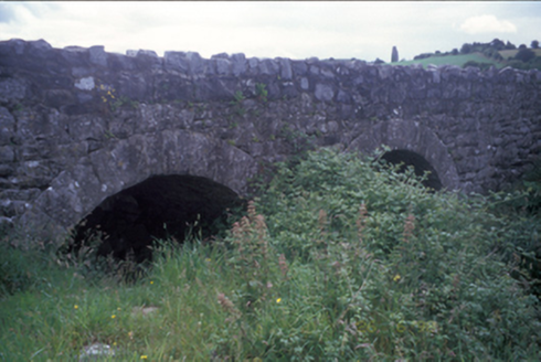 Ballymacquiggan BridgeBridge · 524 yd
Explorer Tom Ballymacquiggan Bridge in County Clare would tell a teenager that the 1800s were basically the same, just without Wi-Fi or good shoes. It’s had some work done recently, but it’s keeping its original bones for nostalgia’s sake. Stop the car and use your hazard lights; this old stone beauty is worth the traffic stop.
Post Office FieldNature reserve · 1.6 miExplorer Tom Post Office Field thinks if it won the lotto, it would buy a stamp collection for every single bird that lands on it. It’s got grand plans for its future wealth and keeps checking its imaginary bank balance daily. Tell your mates you found it first.
 Ennis AbbeyMuseum · 1.6 mi
Explorer Tom Ennis Abbey has been staring down Abbey Street for centuries, with a stone window grand enough to make an ordinary pane feel terribly underdressed. Tom reckons the O’Briens ordered a modest little friary and somebody got carried away with the limestone; take one look inside and you may forgive the excess. This is Ennis Friary, founded by the O’Briens of Thomond for the Franciscans. By 1375 it had grown into a substantial foundation with a renowned school. Its surviving carvings date mainly from the fifteenth and sixteenth centuries, and the local hard limestone gives them the crisp presence of people who still expect to be noticed. Find St Francis displaying the stigmata and the image of Christ with bound hands on the arch between nave and transept. The chancel’s tall east window has five lancets, while the sacristy hides a ribbed barrel vault that rewards looking up. Outside, the graveyard carries more than 300 inscribed stones, most from the eighteenth and nineteenth centuries. Tom would like to claim he can read every life from a weathered letter, but he can barely read his own notes in the rain. Give the stones and their carved details the time they deserve. The Office of Public Works welcomes visitors at Abbey Street in the centre of Ennis from 13 March to 4 November 2026, 10 until 6, with last admission at 5.15. Admission is charged. Some walkways are uneven and access is limited in places; the operator provides a step-free alternative entrance for visitors who need it. Ask the guides about what you have spotted, then let the town reclaim you when the friary finally loosens its grip.
Ardcarney WoodWood · 1.7 miExplorer Tom Ardcarney Wood again! How does it describe the 1800s? It says everyone wore wool socks and complained about the rain with great dramatic flair and zero actual evidence to back up their claims. The history is as solid as a wet biscuit, but the atmosphere is genuinely lovely if you ignore the existential dread of being lost in trees. Stop your car, turn on the hazard lights, and just stand there in懵
 O'Connell ColumnMonument · 1.7 mi
Explorer Tom O'Connell Column is standing tall in Ennis while some local insists he personally carved every single block with a spoon. He’ll tell you it took him three weeks and one very strong cup of tea. Go at sunset and thank me later.
 Clare MuseumMuseum · 1.8 mi
Explorer Tom Clare Museum, tucked into an old convent building on Arthur's Row in Ennis, can take you from Bronze Age treasure to a politician's enormous car without asking you to leave the county. I arrived ready for a quick look and found the place had quietly laid out about six thousand years of reasons to stay longer. The museum opened in 2000 with its Riches of Clare exhibition and gathers objects and stories from across the county. Its displays run over two floors, arranged around Earth, Power, Faith, Water and Energy. That sounds like the title of an ambitious rock album, but it is a wonderfully practical way to understand how people lived, believed and worked here. The building was once part of a Sisters of Mercy convent, another layer in the history of this very address. Look for the replicas of the Mooghaun gold hoard, bog-preserved shoes and butter, and finds connected with the Knocknalappa crannóg. In the foyer sits Éamon de Valera's 1947 Dodge limousine, a vehicle with enough presence to demand its own parking speech. He represented Clare for decades, so the car belongs in this county's story. I asked it for a lift around the exhibition; its chauffeur, sensibly, never appeared. Entry is free and the exhibitions are self-guided, but check current visiting days before setting out: the museum closes on bank holiday weekends and on some ordinary days outside summer. Unlike a generic county timeline, these rooms give you particular objects to argue with, admire and remember. Come out onto Arthur's Row with one small Clare story you did not know when you went in.
 Ballygriffy CastleCastle · 1.8 mi
Explorer Tom Ballygriffy Castle is playing hard to get next to that old West Clare Railway line. A local swears he invented the whole thing himself, which is either brilliant or completely mad. If anyone asks what you're doing there, tell them Tom sent you with a wink.
 Shallee Castle (in Ruins)Castle, tower house · 2.5 mi
Explorer Tom Shallee Castle in Shallee is suspicious of the postman because he keeps delivering bad news about treason and hanged sons. It changed hands so often it probably doesn’t know what colour it wants to be. Mind the nettles, they're the real guards here.
Poul na gollorCave · 2.9 miExplorer Tom Poul na gollor in County Clare was once run by a very aggressive matchmaker who forced every single person entering into a romantic commitment before they could leave. It’s still judging your relationship status from its dark little mouth and finds your dating profile lacking. Tell the next person you meet it's haunted. It might be.
Alice and Gwendoline CaveMuseum · 3.5 miExplorer Tom Alice and Gwendoline Cave is technically a museum now, which means two fairies are fighting over parking rights right under our noses. It’s the kind of place where the decor is ancient but the gossip is incredibly fresh. Bring a notebook and write the bit I made up.
.jpg/250px-Church_of_Rath_Blaithmaic_sheela-na-gig_(upside_down).jpg "Photo: The Banner, Wikimedia Commons · CC BY-SA 3.0") Sheela-na-gig in RathSheela-na-gig · 5.0 mi
Sheela-na-gig in RathSheela-na-gig · 5.0 miExplorer Tom Sheela-na-gig in Rath is upside down over a window recess, probably judging your fashion choices. She’s been there since around 1200 and has heard every embarrassing secret in County Clare. Bring a map, get lost anyway, that's the real fun.
More archaeology and monuments in County Clare · All of County Clare

What do you know about this place?Tap to add a comment or ask a question