What is recorded here
From the National Monuments Service (Archaeological Survey of Ireland) record CV028-014
Places near here
Photo credits
- Kieran Campbell, Geograph · Creative Commons Attribution-ShareAlike 2.0
- National Inventory of Architectural Heritage
- Eric Jones, Geograph · Creative Commons Attribution-ShareAlike 2.0
- Oliver Dixon, Geograph · CC BY-SA 2.0
- Wanfried-Dublin, Wikimedia Commons · CC BY-SA 4.0
- Stephan van Helden, Wikimedia Commons · CC BY-SA 4.0
 Glasleck Presbyterian ChurchChurch/chapel · 753 yd
Explorer Tom Glasleck Presbyterian Church was built in 1836 and now stands disused, but its pointed arch windows still look quite striking.
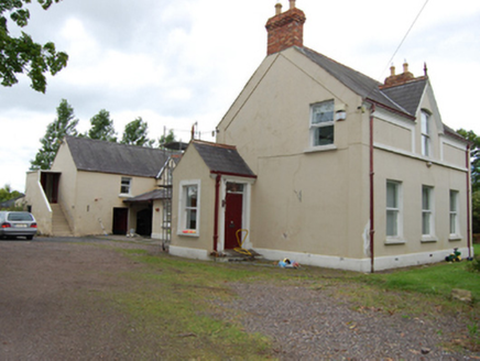 The ManseManse · 768 yd
Explorer Tom The Manse in Glasleck is a detached L-plan house built around 1890, featuring a central gabled dormer and carriage arch.
 Green IslandIsland · 1666 yd
Explorer Tom Green Island is a lush little spot in County Cavan that looks like it’s straight out of a stock photo of Irish mountains and trips.
 Graveyard1.2 mi
Explorer Tom Perched on a knoll above the valley, this graveyard sits beside the church where headwaters trickle toward Milltown Lough.
DerrynureMountain / peak · 1.5 miExplorer Tom Derrynure stands as a modest peak in County Cavan, its name rolling off the tongue like a local greeting.
CorravillaMountain / peak · 2.0 miExplorer Tom Corravilla is a peak in County Cavan, and I imagine its slopes are dotted with garden ornaments that look like they belong in a fairy tale.
 Bush IslandIslet · 2.5 mi
Explorer Tom Bush Island might actually be a hidden crannog in Lough Sillan, waiting for us to discover its secret, mossy, ancient history today.
 Welcome to Bailieborough DemesneVisitor information · 2.8 mi
Explorer Tom Welcome to Bailieborough Demesne, where you might spot the famous Castle Lough recreation area.
 Wedge tomb in LisnadarraghWedge tomb · 3.5 mi
 Brothers GravesVisitor information · 3.8 mi
Explorer Tom Brothers Graves holds a touching memory, marking seven Marist brothers who lived long lives in this community.
 LoughanleaghForest · 3.9 mi
Explorer Tom Loughanleagh has waymarked paths, so you won’t get lost, but I bet there are plenty of shortcuts for those who know where to look.
 Horse-chestnut5.8 mi
Explorer Tom A majestic Horse-chestnut in County Cavan, likely dropping glossy green cones and releasing sweet-smelling flowers that fill the air with fragrance.
More archaeology and monuments in County Cavan · All of County Cavan
What do you know about this place?Tap to add a comment or ask a question