Places near here
Photo credits
- National Inventory of Architectural Heritage
- Zepherb, Wikimedia Commons · CC BY-SA 4.0
- Didier Descouens, Wikimedia Commons · CC BY-SA 4.0
- Andreas F. Borchert, Wikimedia Commons · CC BY-SA 4.0
- Picture: The Standing Stone
- Hugh Chevallier, Wikimedia Commons · CC BY-SA 2.0
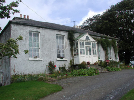 Heath LodgeHouse · 753 yd
Explorer Tom Heath Lodge in Droughtville looks tiny from the front but massive from the back, like a secret-keeper with a big mouth. A bishop refused to visit because he said the roof was too steep for his hat. Have a look and decide if it’s hiding something.
CastleCastle, tower house · 765 ydExplorer Tom Castle in Annaghmore AND Annaghbeg is claimed by a local who says he invented the concept of walls. It’s buried in marshy overgrowth, so you’re basically visiting a rumour with two musket loops. If anyone asks, Tom sent you.
Knockbarron WoodForest · 1223 ydExplorer Tom Knockbarron Wood in County Offaly was once nearly sold off as a prize horse at the local fair, and honestly, that might have been its best life choice. It still acts a bit prancy when the wind blows through it, like it’s waiting for its rider to return. Go at sunset and thank me later.
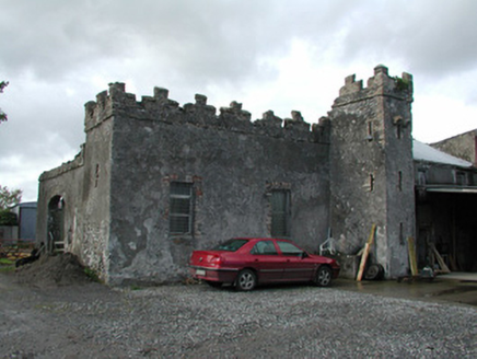 Cloganmore HouseFarm house · 1653 yd
Explorer Tom Cloganmore House would tell you in a job interview that it’s 'defensively ambitious' despite being just a farm. The slit windows look like they’re hiding from the modern world. Count the crows, they know the secrets.
Waypoint 1Visitor information · 2.1 miExplorer Tom Waypoint 1 is a visitor info spot with the confidence of a celebrity but the substance of a dry biscuit. It thinks posting 'Lost? Check here!' makes it a major landmark, but really it’s just a signpost that got confused about its career path. It’s probably currently buffering a PDF guide from 1994 while you stand there wondering why you’re here. Pretend you're a lost aristocrat
Slieve Bloom Mountain Bike TrailVisitor information · 2.2 miExplorer Tom Slieve Bloom Mountain Bike Trail is run by a dog who thinks he’s the king of the forest. He barks at your tires like they’ve personally offended his ancestors. The trail is rugged, but the dog’s enthusiasm is even more so. Ideal for a moody photo you'll pretend wasn't posed.
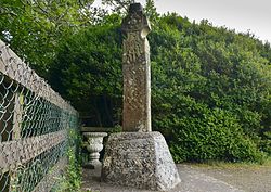 Stone CrossCross, High cross (present location) · 2.2 mi
Explorer Tom Stone Cross in Castletown was designed by a mother-in-law who thought everyone needed a lecture on biblical scenes. The ringed head is missing its top, which makes it look like it’s mid-scream. It’s still standing there, judging your geometry skills. Tell it a joke, it's been a long time since anyone did.
Saint Dominick's WellSpring · 2.6 miExplorer Tom Saint Dominick's Well in County Offaly claims it’s older than the hills, which is a lie because the hills are lazy. It’s a spring with a grand name but a very modest water supply. The legends say it’s ancient, but I think it just woke up late. Look serious, nod slowly, you're basically an expert now.
 Hawthorn3.2 mi
Explorer Tom This Hawthorn in County Offaly witnessed a love story where one party got very stung, literally speaking. It’s still holding a grudge against roses. A proper spot for a flask of tea and a big think.
 Settlement desertedSettlement deserted, medieval · 3.2 mi
Explorer Tom Settlement deserted in Bellhill is a medieval mess that Saint Patrick would probably call 'a bit much'. It has a round tower, a church, and a tunnel, all squashed together like sardines. I bet he’d say it needs a good scrub and a new roof. Find the wonkiest bit and send it to your group chat.
 Ballymooney Castle in RuinsHouse, fortified house · 3.8 mi
Explorer Tom Ballymooney Castle in Ruins is mostly gone, but two towers are still standing guard like tired bouncers. Two lads once bet it would survive the rain, and it did, barely. It’s got a very 'I’m still here' energy despite the marsh next door. Spot the oldest stone and give it a name.
 ArderinMountain / peak · 6.2 mi
Explorer Tom Arderin means Ireland's height, which is a cheeky name for a 527-metre hill and exactly the sort of confidence I admire. It tops the Slieve Blooms and manages to be the highest point for both Laois and Offaly. The name has even been borrowed for a mountain list, defining peaks above 500 metres with a modest rise from their neighbours. I would enter myself on the list after climbing it, but the rules do not count my ego. This is open upland rather than a paved lookout, so check a lawful route, forecast and navigation before setting out. Respect working forestry or farmland around the approaches. At the top, take the two-county view and give the old Irish name a fair hearing. A hill need not be enormous to own its place on a map.
More archaeology and monuments in County Offaly · All of County Offaly

What do you know about this place?Tap to add a comment or ask a question