What is recorded here
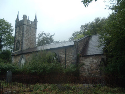
On N side of road, in parish of Dromtarriff c. 850m NW of Dromtarriff church (CO031-03502-). Subrectangular tree-lined graveyard (c. 50m N - S; c. 40m E - W) with C of I Church (CO031-24202-) in N half. Burials mainly confined to S of church. Headstones dating from mid 19th century to present day.
From the National Monuments Service (Archaeological Survey of Ireland) record CO030-242001
The monument record does not grant public access. Check the route and ask the landowner before entering private land.
- What survives
- Recorded monument
Places near here
Photo credits
- National Inventory of Architectural Heritage
- Maker shown on the Wikimedia Commons file page · CC BY-SA 3.0
- The Speckled Bird, Wikimedia Commons · CC BY-SA 4.0
- Jonathan Thacker, Geograph · Creative Commons Attribution-ShareAlike 2.0
- Jonathan Thacker, Geograph · CC BY-SA 2.0
- Mike Searle, Wikimedia Commons · CC BY-SA 2.0
 church/chapel22 ydCastle (Site of)Bawn · 408 ydDromaghMiner's settlement · 893 yd
 Fr John Barry MemorialMonument · 1311 yd
 Battle of KnocknaclashyBattle · 1.5 miRathcool WoodWood · 2.6 mi
 Kanturk CastleHeritage attraction · 3.8 miSt Fursey's WellSpring · 4.3 mi
 Grave YardGraveyard · 4.7 mi
 Mount Hillary - Father Murphy LoopWalking route · 4.7 mi
 Castle and TurretCastle, tower house · 4.8 mi
 St. Patrick's ChurchVisitor information · 6.2 mi
More archaeology and monuments in County Cork · All of County Cork
What do you know about this place?