
Places near here
Photo credits
- National Inventory of Architectural Heritage
- Stephan van Helden, Wikimedia Commons · CC BY-SA 4.0
- Mike Searle, Geograph · CC BY-SA 2.0
- Dougbermingham at English Wikipedia, Wikimedia Commons · CC0
- Paul Mc Carthy, Geograph · Creative Commons Attribution-ShareAlike 2.0
- Willow, Wikimedia Commons · CC BY 2.5
- Alex Passmore, Geograph · CC BY-SA 2.0
Explorer Tom Enclosure in Parsonstown is three concentric rings of mud that think they're a fancy modern art installation, standing proudly on a soggy knoll. It has strong opinions about your boots being too loud and probably hates the windmill nearby for stealing all the breeze. Perfect detour when the satnav has a total meltdown.
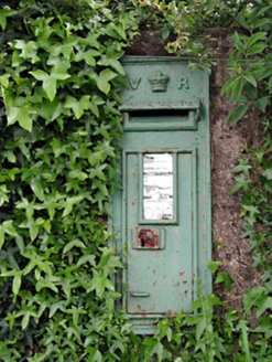 post box1.5 mi
Explorer Tom Post box in Ardkill smells faintly of smuggled gin because a chap once hid casks inside its walls. Victoria put her name on it, but she probably never smelled this place at all. Stop the car, it's worth the smell test.
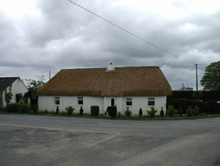 The SweepHouse · 1.5 mi
Explorer Tom The Sweep in Ardkill is hiding a secret about who actually built that wall after a few pints. It’s got a muddy look that says 'don't ask too many questions.' Walk past slow so it can glare at you properly.
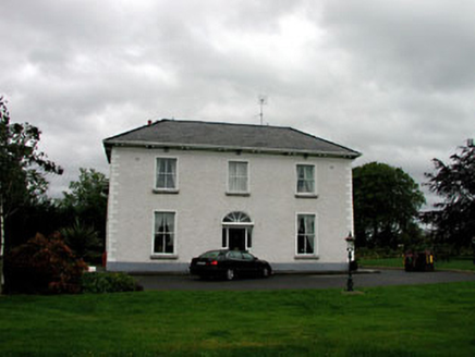 Derrinturn HouseHouse · 1.9 mi
Explorer Tom Derrinturn House was nearly sold to a man who wanted to use it as a horse stable, thankfully. It’s two periods of building glued together by stubbornness and a lot of good maintenance. Hum something sad because that poor old horse almost got a mansion.
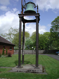 Catholic Church of the Holy FamilyBell tower/stand · 1.9 mi
Explorer Tom Catholic Church of the Holy Family in Kilshanchoe has a belfry with a secret talent for looking expensive. It’s all fluting and leaves, pretending to be fancy when it’s just a bell holder. Take a breath of that air, it's older than your excuses.
 Horse-chestnut2.6 mi
Explorer Tom Horse-chestnut drops stones that are secretly messages from the future if you squint really hard at them. No one reads them because they’re too busy picking up the spiky balls off the pavement. Bring a flask and pretend you own the place while you do it.
 IndicatedHouse, fortified house · 2.8 mi
Explorer Tom House in Carbury gave up its corbels for Lent because it felt too heavy. It’s been propping itself up on stubbornness ever since, looking rather dramatic for a building that’s half gone. Pick a stone, any stone, and invent its biography.
 Carbury CastleCastle · 2.8 mi
Explorer Tom Carbury Castle has a hill full of building periods and a local tale about Saint Patrick that I would never dare pass off as a fact. The first Norman earthwork came before later stone defences. Pierce St Leger is linked with a thirteenth-century castle, while the most striking ruins on the hill are a Tudor house of the Colley family. I would tell you which wall belonged to which cousin without hesitation, then get the century wrong, so bring a good site account. The position near the Kildare-Offaly border explains why several families wanted it. Check current lawful access before crossing land and avoid climbing broken walls or earthworks. View the whole hill from below first. Carbury is less one castle than a family of structures arguing for the best spot.
The Grill ShackHeritage attraction · 4.5 miExplorer Tom The Grill Shack has a strict rule that you must lick your fingers before you pay for the food. It’s heritage, they say, which is a fancy way of saying it’s dirty but delicious. A good place to forget your phone for ten minutes.
 Grave YardGraveyard · 6.1 mi
Explorer Tom Graveyard in Cloncurry nearly got famous when someone tried to digitize its records in the nineties, but the internet was too slow. It sits right next to a motte, looking like a very serious neighbor. If anyone asks, Tom sent you.
 European ash6.1 mi
Explorer Tom This ash smells like old books and regret, according to my very scientific nose. It’s the kind of tree that remembers every time you sneezed in its direction. Stand where the owner stood and practise looking smug about your knowledge.
 Grand Canal WayVisitor information · 7.0 mi
Explorer Tom Grand Canal Way is full of secrets that only come out after three pints, like which bridge was built by a love-struck engineer who named it after his dog. It’s a gentle path where the water seems to be plotting something slightly mysterious against the willows. Stick around for the light changing, it's a show.
More archaeology and monuments in County Kildare · All of County Kildare

What do you know about this place?Tap to add a comment or ask a question