
What is recorded here
From the National Monuments Service (Archaeological Survey of Ireland) record MA115-002
Places near here
Photo credits
- Colin Park, Geograph · CC BY-SA 2.0
- Newbert12, Wikimedia Commons · CC BY-SA 4.0
- Britishfinance, Wikimedia Commons · CC BY-SA 4.0
- Maker not stated on source page, www.pinterest.com
- Maker not stated on source page, commons.wikimedia.org
- Gordon Dunn, Wikimedia Commons · CC BY-SA 2.0
- Hajotthu, Wikimedia Commons · CC BY-SA 3.0
- Oliver Dixon, Geograph · CC BY-SA 2.0
- dalvenjah on Flickr, Wikimedia Commons · CC BY-SA 2.0
- Maker not stated on source page, www.irishamericanmom.com
- Kahuroa, Wikimedia Commons · Public domain
 Mweelrea se SpurMountain / peak · 835 yd
Explorer Tom Mweelrea SE Spur is the part of the mountain that everyone ignores because they’re too busy looking at the main peak. A…
 Salrock ChurchChurch/chapel · 1.1 mi
Explorer Tom Salrock Church was built on a bargain where the devil traded good lighting for a slightly crooked steeple, which I…
 MweelreaMountain / peak · 1.2 mi
Explorer Tom Mweelrea is Connacht's highest mountain, and it has no interest in pretending that 814 metres is a casual afternoon. It…
 Tobersalrock Holy well (Site of)Holy well · 1.2 mi
Explorer Tom Tobersalrock Holy well in Foher is how many cups of tea it took to build. It’s gone now, but the church nearby still…
 Fairy fort / stone ringfort in Lettergesh EastFairy fort / stone ringfort · 2.0 mi
Explorer Tom Fairy fort / stone ringfort in Lettergesh East is an oval cashel on a small hill, commanding a pass between two loughs.…
 Uggool BeachBeach / strand · 2.4 mi
Explorer Tom Uggool Beach is secretly proud of one specific potato growing in its sand, which I think is hilarious given the…
 Silver StrandBeach / strand · 3.0 mi
Explorer Tom Silver Strand in County Mayo does some very strange things when nobody’s looking, like rearranging its own pebbles into…
 Kylemore AbbeyMausoleum · 4.6 mi
Explorer Tom Kylemore Abbey’s mausoleum is the quiet cousin at the wedding, wearing yellow bricks that scream 'I’m different'. It…
 White StrandBeach / strand · 4.8 mi
Explorer Tom White Strand has a name so simple it feels like a cheat code for finding peace, but don’t let that fool you. It’s…
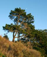 Monterey Pine4.8 mi
Explorer Tom Monterey Pine in County Galway once saw a fox try to climb it but get stuck halfway up because the branches were too…
 The WaterfallVisitor information · 4.9 mi
Explorer Tom The Waterfall is planning to spend its lotto win on a very expensive pair of swim trunks and a vacation to the moon…
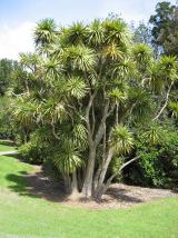 Cabbage tree5.1 mi
Explorer Tom Cabbage tree in County Galway looks like it’s waiting for a bishop who refused to visit because the leaves were too…
More archaeology and monuments in County Mayo · All of County Mayo

What do you know about this place?Tap to add a comment or ask a question