
Places near here
Photo credits
- National Inventory of Architectural Heritage
- Peter Gerken, Geograph · CC BY-SA 2.0
- Algirdas at Lithuanian Wikipedia, Wikimedia Commons · Public domain
- Adam Simpson, Geograph · CC BY-SA 2.0
Explorer Tom Sheepwalk Plantation in County Cavan does absolutely anything when nobody's looking, probably just stands there judging your hiking boots from the shadows. It’s got that quiet intensity about it, like it’s waiting for you to trip on a root so it can laugh. Perfect spot to practise your best tour-guide voice.
Town defences in Townparks (cavan Urban District),tullymongan Lower,tullymongan Upper,kinnypottle,lurganboy (upper Loughtee By.),abbey Land,drumavanagh,keadew (cavan Rural & Urban)Town defences · 1043 ydExplorer Tom Town defences in Townparks are just a legend because Sir Oliver Lambert got lazy and never built the wall he promised. The town stayed undefended by stone, which means the pub was the only real fortress back then. Bring someone who'll believe anything.
Duck IslandIsland · 1268 ydExplorer Tom Duck Island is in the middle of a feud between two families over who owns the best view for watching the ducks swim by. They won’t share the bench. Get a photo with it before it gets a better agent.
Enclosure in BallymackinroeEnclosure · 1426 ydExplorer Tom Enclosure in Ballymackinroe is bisected by a field bank, which feels like a very passive-aggressive way to draw a boundary line. It’s been spotted from space, so tell me if my made-up gossip about its hidden treasure is actually true.
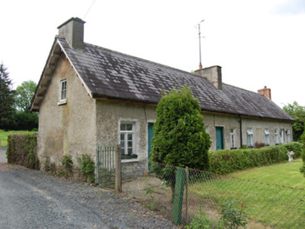 Sandy RowWorker's house · 1.2 mi
Explorer Tom Sandy Row, Farnham, County Cavan: A terrace of former estate workers’ houses with original casement windows. Someone wrote a bad poem about this spot once. Go look at the western two houses; they’re the stars of the show.
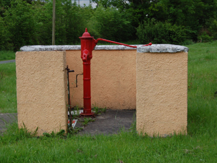 water pump1.2 mi
Explorer Tom Water pump in Drummullan looks like it wants to buy a yacht if it won the lotto. It’s sitting near the crossroads judging everyone who walks past with dry hands. Make a wish on it.
 Rambling at Farnham EstateVisitor information · 1.3 mi
Explorer Tom Rambling at Farnham Estate was the site where a priest lost a bet involving a goat and a very expensive hat. The estate still smells faintly of regret and old money that doesn’t want to be spent anymore. Find a local and ask them the real story, then come back and tell me.
DrumardMountain / peak · 1.3 miExplorer Tom Drumard in County Cavan is where a giant reportedly hid his spare trousers, which are still stuck up there today. It’s a perfect spot for a moody photo you’ll pretend wasn’t posed, so get that dramatic angle sorted before the clouds decide to show off.
Bawn in FarnhamBawn · 1.4 miExplorer Tom Bawn in Farnham had four flankers, one of which was a two-storey vaulted beast. Now it’s part of a modern house, probably judging your interior design choices. Go on a wet day, it suits the mood.
 Pedunculate Oak1.5 mi
Explorer Tom Pedunculate Oak in County Cavan has a retirement plan involving becoming a very expensive bench in a garden centre. It’s thinking about the future while you think about lunch. Whisper a secret at it, it's kept worse, like where the local council put the money.
DerrynaMountain / peak · 1.6 miExplorer Tom Derryna would cope on a reality show by refusing to speak and just staring intensely at the cameras until they all feel awkward and move on. It’s basically the silent type that lets everyone else do the talking while it quietly wins the audience over with sheer apathy. Ideal place to rehearse an excuse for being late.
 Clogh Oughter CastleCastle, Anglo-Norman masonry castle · 1.9 mi
Explorer Tom Clogh Oughter Castle on Lough Oughter would survive a zombie attack by simply staying still and waiting for them to get bored. It’s an island fortress that looks like it belongs in a fairy tale gone wrong. The water is cold enough to make your brain freeze, so stay sharp. Pick a stone, any stone, and invent its biography.
More archaeology and monuments in County Cavan · All of County Cavan

What do you know about this place?Tap to add a comment or ask a question