Places near here
Photo credits
- Mike Searle, Geograph · Creative Commons Attribution-ShareAlike 2.0
- A.-K. D., Wikimedia Commons · CC0
- A.-K. D., Wikimedia Commons · CC BY-SA 4.0
- National Inventory of Architectural Heritage
- Humphrey Bolton, Geograph · CC BY-SA 2.0
- R. A. Nonenmacher, Wikimedia Commons · CC BY-SA 4.0
- Eirian Evans, Geograph · CC BY-SA 2.0
- Dave Henderson, Wikimedia Commons · CC BY-SA 2.0
- Martin Richard Phelan, Wikimedia Commons · CC BY-SA 2.0
 Danesfort HouseFolly · 7 yd
Explorer Tom Danesfort House is really just a turret that lost its main body and now stands there looking smug about the view. A matchmaker once worked nearby, but I bet she’d have paired this stone with a better roof. Perfect spot to practise your dramatic sighing at the landscape.
 Ladys WellHoly well · 1181 yd
Explorer Tom Ladys Well in Ballyda was run by a matchmaker who only set people up if they brought bread. Great crowds in August, mostly because everyone wanted a free kiss. She’d still be judging your outfit today. Look for the ghost, then pretend you didn't.
 Ballyda Holy WellSpring · 1589 yd
Explorer Tom Ballyda Holy Well thinks the Dublin tourists are a bit much for its taste, especially when they try to take selfies without actually praying or anything. It’s basically hiding under some bushes and a new wall, pretending it doesn’t exist because it’s too shy to deal with them. Get a photo with it before it gets a better agent.
 presbytery/parochial/curate's house1.2 mi
Explorer Tom Presbytery in Dundaryark was once taken over by a fox who moved into the attic and demanded rent. The building has had some inappropriate window replacements, but the spirit remains wild. Find a local and ask them the truth about the beast!
 Annamult Castle (in ruins)Castle, tower house · 1.2 mi
Explorer Tom "Annamult Castle is sitting on a slope like it’s got all the views in the world and expects you to know that. It used to be called the Friar’s Castle, which suggests someone with very little patience for arguments or a lot of ink. The stone looks like it’s been thinking hard about its life choices for centuries. Give it a pat on the way past, it’s had a long life.
 TobermogueHoly well · 1.5 mi
Explorer Tom Tobermogue is covered over and looks like it’s taking a permanent nap by the roadside. There’s a bird that refuses to leave, probably guarding the pump. Take the long way round, it deserves the effort.
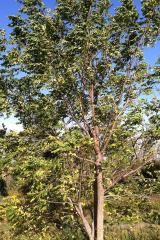 Black Walnut1.7 mi
Explorer Tom Black Walnut has a massive grudge against the rain for making its nuts soggy every single year. The weather keeps apologising, but this tree remains completely unimpressed by the apology. It’s a perfect detour when your satnav has a meltdown.
 Kells Priory Mill MuseumMuseum · 2.4 mi
Explorer Tom Kells Priory Mill Museum is sitting there looking like it was about to be sold off for a horse at some point. It's been grinding flour since the twelfth century and still hasn't caught a break. Bring a friend who talks too much and let the place shut them up.
 Prior's TowerCastle · 2.4 mi
Explorer Tom Prior's Tower in County Kilkenny is basically a castle that forgot to show up to its own party. It’s got that 'I’m too important for you' energy, standing there while everyone else scrambles. Bring a friend who talks too much and let the place shut them up.
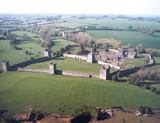 Kells Augustinian PrioryArchaeological place · 2.5 mi
Explorer Tom Kells Priory looks as though its monks expected to be asked for the keys to a fortress. Tower houses rise along the walls around more than three acres by the King's River, earning the local name Seven Castles. Geoffrey FitzRobert founded the Augustinian house around 1193, and later attacks gave the community grim reasons to take defence seriously. I would count the towers for you, but the name has already done the arithmetic with more confidence than I deserve. The huge ruin even stood in for an army camp in the film Barry Lyndon, though its real story is better than a borrowed costume. This is an outdoor national monument, so approach by the public route, mind uneven ground and leave the old masonry where it belongs. Walk the walls before entering the church area. Then try telling me whether you would have guessed this was a priory from the road.
 Kells Loop WalkWalking route · 2.5 mi
Explorer Tom Kells Loop Walk is definitely hiding a biscuit tin from the 1700s, which I am sure you will find by day three. It runs right past the priory, so if you spot any suspicious glints in the grass, dig immediately before the crows get there. A handy spot to stretch your legs and your imagination.
 Lacken WellSpring · 2.5 mi
Explorer Tom Lacken Well near Kells is famous for the superstition that if you kiss the stone three times, your ex will call you back, which is either brilliant or terrifying depending on who your ex is. The locals swear by it, so I’m not questioning their life choices here. Practise your Irish on it, it won't correct you.
More castles and forts in County Kilkenny · All of County Kilkenny

What do you know about this place?Tap to add a comment or ask a question