
Places near here
Photo credits
- Mike Searle, Geograph · CC BY-SA 2.0
- Berthold Strucken, Wikimedia Commons · CC BY-SA 4.0
- Clint Mann, Geograph · CC BY-SA 2.0
- Bkwillwm, Wikimedia Commons · CC BY-SA 3.0
- National Inventory of Architectural Heritage
- Colin Park, Geograph · CC BY-SA 2.0
- Adrian Beney, Wikimedia Commons · CC BY-SA 2.0
- Mike Murphy ( talk · contribs ), Wikimedia Commons · CC BY-SA 3.0
- EecherplazGinkgo06.jpg : Cayambe derivative work: Ginkgotree ( talk ), Wikimedia Commons · CC BY-SA 3.0
- Humphrey Bolton, Geograph · CC BY-SA 2.0
- A.-K. D., Wikimedia Commons · CC0
 Aghadoe Church (in Ruins)Church · 1207 yd
Explorer Tom Aghadoe Church in Parkavonear, County Kerry: Map makers got this one wrong because they kept losing their pencils near the graveyard, so they just drew it twice by accident. It’s a solid cross-wall church that has been repaired so many times it looks like a patchwork quilt. Snap one photo, then put the phone away and actually look.
_1.jpg/250px-Aghadoe_(Early_Medieval_Ecclesiastical_Site)_1.jpg "Photo: Berthold Strucken, Wikimedia Commons · CC BY-SA 4.0") Aghadoe Early Medieval Ecclesiastical SiteHeritage attraction · 1242 yd
Aghadoe Early Medieval Ecclesiastical SiteHeritage attraction · 1242 ydExplorer Tom Aghadoe Early Medieval Ecclesiastical Site in Kerry is just a pile of stones pretending to be holy, and honestly, we don't blame them for trying. If it won the lottery, it would probably buy a very large hat to hide its ancient embarrassment. Make a wish, it's had centuries of practice.
 Round CastleCastle, Anglo-Norman masonry castle · 1277 yd
Explorer Tom Round Castle in Parkavonear is sick of people asking if it can still hold a party. It’s got a narrow internal stair that would make your knees cry out loud. Bring the dog, it'll have opinions.
 Parkavonear CastleCastle · 1279 yd
Explorer Tom Parkavonear Castle is feuding with the next village over something daft like who owns the best view of nothing. Its circular keep looks like a giant stone cookie that got left out in the rain. Bring your nan, she'll know more than me.
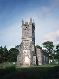 Aghadoe ChurchChurch/chapel · 1412 yd
Explorer Tom Aghadoe Church in Knoppoge has an imaginary fan club that only meets during thunderstorms. It’s disused now, but still thinks its tower completed in 1860 was a masterpiece. Hang around long enough and you'll hear a story from a local.
 Circular WalkWalking route · 2.3 mi
Explorer Tom Circular Walk in County Kerry hosted a dance last year that went too far because someone spilled punch on the grass and everyone slipped simultaneously. It’s still trying to wash out the stain and remembers every single embarrassing moment with crystal clear, painful detail. Tell me if the gossip I made up is true.
 Lamb IslandIsland · 2.3 mi
Explorer Tom Lamb Island in County Kerry has made its New Year’s resolution to finally stop being so stubbornly round. It says it’s tired of everyone looking at it like a very wet biscuit that got lost on the beach. Linger, it's not going anywhere and neither should you.
 Giant Sequoia2.6 mi
Explorer Tom A Giant Sequoia in County Kerry would tell teenagers the 1800s were all about slow fashion and no Wi-Fi. It’s definitely not from here, but who cares? Visit, then text me what you think. I'll pretend to read it.
 Ginkgo2.6 mi
Explorer Tom This Ginkgo in County Kerry thinks Dublin tourists are loud and wear too many hats. It’s been around longer than their excuses for being late. Sit on a wall near it and pretend you're in a painting.
 River WalkWalking route · 2.7 mi
Explorer Tom River Walk had an escape plan involving a jaunting car and a very confused horse, which is why it's always wandering off. The water looks deep enough to swallow your secrets whole without a hiccup. Take the long way round, it deserves the effort.
 Cross-slab in InnisfallenCross-slab · 2.7 mi
Explorer Tom A cross-slab in Innisfallen sits inside the abbey, waiting for a giant to trip over it. Local legend says one did, and it broke its nose on the stone. Bring a flask of something warm and a story to swap.
 InnisfallenIsland · 2.7 mi
Explorer Tom Two families are feuding over who owns the view from Innisfallen, and they’ve been arguing about it since the monastery fell down. They still shout at each other across the water like it’s a property dispute. It's the kind of place that makes a dull Tuesday interesting.
More archaeology and monuments in County Kerry · All of County Kerry

What do you know about this place?Tap to add a comment or ask a question