Places near here
Photo credits
- Peter Ribbans, Wikimedia Commons · CC BY-SA 2.0
- Kmcnamee, Wikimedia Commons · CC BY-SA 4.0
- National Inventory of Architectural Heritage
- Nigel Cox https://www.geograph.org.uk/profile/2798, Wikimedia Commons · CC BY-SA 3.0
- A.-K. D., Wikimedia Commons · CC BY-SA 4.0
- Nigel Cox, Wikimedia Commons · CC BY-SA 2.0
- Richard Webb, Geograph · CC BY-SA 2.0
- This Photo was taken by Timothy A. Gonsalves . Feel free to use my photos, but please mention me as the author. I would much appreciate if you send me an email tagooty@yahoo.com or write on my talk page , for my information. Please contact me before commercial use. Please do not upload an edited image here without consulting me. I would like to make corrections only at my own source to ensure that the changes improve the image and are preserved. Otherwise you may upload an edited image with a new name. Please use one of the templates derivative or extract ., Wikimedia Commons · CC BY-SA 4.0
 Ballycrovane Ogham StoneVisitor attraction · 1.0 mi
Explorer Tom The Ballycrovane Ogham Stone claims King Arthur once leaned on it while complaining about his back, which nobody can…
 Páirc na hAoraí, UrhanGAA ground · 1.1 mi
 coastguard station1.2 mi
Explorer Tom “Coastguard station in Faunkill-and-the-woods had a fox take charge of the watch for a week and honestly did a better…
 garda station/constabulary barracks1.3 mi
Explorer Tom Garda station in Eyeries, County Cork is now a private house but still feels like you need to show an ID badge. Built…
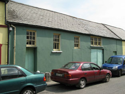 workshop1.3 mi
Explorer Tom Workshop in Eyeries has windows placed like it lost a bet with geometry. It’s still standing while others got…
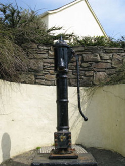 water pump1.4 mi
Explorer Tom Eyeries’ water pump is wearing a ram's head bucket grip like it’s a fancy accessory. Cast iron from 1870, and it’s…
 Hag of BearaMonument · 1.8 mi
Explorer Tom Hag of Beara in County Cork is stuck in a long-standing grudge with the weather, which keeps trying to blow her away.…
 Graveyard2.0 mi
Explorer Tom Graveyard in Gortgarriff overlooks the harbour and complains about tourists taking selfies instead of paying their…
 Kilcatherine Ch (in Ruins)Church · 2.0 mi
Explorer Tom Kilcatherine Ch is named after a cat goddess who probably still rules the roost here. There’s a stone head above the…
 KnockgourMountain / peak · 5.3 mi
Explorer Tom Knockgour rates its visitors on a scale of one to ten, based mostly on how loud they are. It gives a solid two stars to…
 Allihies Copper Mine MuseumMuseum · 6.6 mi
Explorer Tom Allihies Copper Mine Museum sits at the far end of the Beara Peninsula, where the Atlantic looks ready to swallow the…
Skelligs Rangers GAA pitchGAA ground · 23 miMore archaeology and monuments in County Cork · All of County Cork

What do you know about this place?Tap to add a comment or ask a question