
Places near here
Photo credits
- National Inventory of Architectural Heritage
- Mike Searle, Wikimedia Commons · CC BY-SA 2.0
- Didier Descouens, Wikimedia Commons · CC BY-SA 4.0
- AmandaMcCrann, Wikimedia Commons · CC BY-SA 4.0
- Gillaween, Wikimedia Commons · CC BY-SA 4.0
- Sawyer777, Wikimedia Commons · CC BY-SA 4.0
- Duncan Grant, Wikimedia Commons · CC BY-SA 2.0
- Willow, Wikimedia Commons · CC BY 2.5
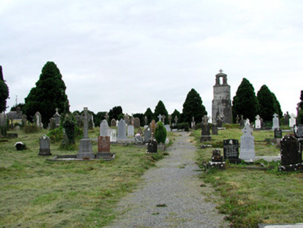 Saint Joseph's Catholic ChurchGraveyard/cemetery · 2.4 mi
Explorer Tom Saint Joseph's Catholic Church graveyard is showing off its family tree, which is mostly made up of very fancy stones and zero actual relatives. The old church ruins are just sitting there judging everyone’s posture from the back row. Give the Celtic crosses a quick wave.
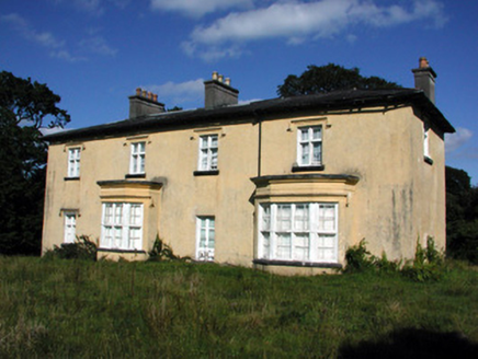 Cashlieve HouseCountry house · 2.4 mi
Explorer Tom Cashlieve House in Cashlieve is the type of person who shows up to weddings wearing a tuxedo but forgets the tie and acts shocked when asked. It’s all about those canted bays, like the house is trying to hug the street while hiding its front door. If you spot it from the road, tip your hat; it’s too shy to wave back.
Workhouse MemorialMemorial · 2.7 miExplorer Tom Workhouse Memorial has an imaginary fan club made entirely of people who really enjoy suffering for art’s sake. It’s not exactly glamorous, but it does have a certain gritty charm that no fancy museum can ever quite replicate. A handy spot to stretch your legs and your imagination.
Silver IslandIslet · 3.3 miExplorer Tom Silver Island is named after a priest who lost a bet about how shiny it looks at sunset. He probably owed someone a pint and has been regretting it ever since. Ideal place to rehearse your best excuse for being late to work tomorrow morning.
.jpg/250px-Castles_of_Connacht-_Ballintober,_Roscommon_(geograph_1954203).jpg "Photo: Mike Searle, Wikimedia Commons · CC BY-SA 2.0") CastleCastle, Anglo-Norman masonry castle · 5.1 mi
CastleCastle, Anglo-Norman masonry castle · 5.1 miExplorer Tom Castle in Ballintober claims a local guy invented it, which is nonsense since the Red Earl built it. But he's charming, so who am I to argue? Bring a pen pal, they'll be jealous of your tales.
_-_geograph.org.uk_-_1952978.jpg/250px-Castles_of_Connacht,_Glinsk,_Galway_(2)_-_geograph.org.uk_-_1952978.jpg "Photo: Mike Searle, Wikimedia Commons · CC BY-SA 2.0") Bawn in Glinsk (ballymoe By.)Bawn · 7.5 mi
Bawn in Glinsk (ballymoe By.)Bawn · 7.5 miExplorer Tom Bawn in Glinsk listens to what goes on inside the walls and probably hears the Burkes arguing about who left the light on in 1630. It’s a well-preserved semi-fortified house that looks like it’s judging your posture, so stand up straight or don’t bother knocking. It's free, it's odd, what more do you want?
 Hawthorn9.3 mi
Explorer Tom Hawthorn in County Roscommon keeps getting picked on by the wind because it thinks being prickly makes it tough. The flowers look like they’re trying too hard to be pretty, but the thorns say otherwise quite clearly. Snap one photo, then put the phone away and actually look.
 IndicatedRound tower · 9.3 mi
Explorer Tom Round tower in Carroweighter is constantly losing a rivalry with the ones in Kildare, which are way too showy for their own good. It stands there with its arms crossed, pretending it doesn’t care that everyone else gets the tourists. Count the crows, then count them again to be sure.
 The Mórrígan: OweynagatLegend location · 10.0 mi
Explorer Tom The Mórrígan: Oweynagat is called the Cave of Cats, which fooled me into expecting a very ordinary sort of trouble. Then the tale sends the Mórrígan out of it during the Táin. If the cats saw her coming, I bet they made room.
 Queen Medb: RathcroghanLegend location · 10 mi
Explorer Tom Queen Medb: Rathcroghan is where the Táin starts turning a quarrel about a bull into an epic. Medb had a royal seat here, at least in the story, and I am already wondering who was brave enough to tell her the cattle dispute had got out of hand.
 CashelFairy fort / stone ringfort · 11 mi
Explorer Tom Another cashel in Kilcashel stands tall on the ridge, looking down its nose at everyone else with its thick, sturdy drystone walls. The builder was definitely thinking about views when they stacked those rocks, ignoring the wind and the cold completely. Bring biscuits, every good story needs biscuits.
 European ash13 mi
Explorer Tom European ash in County Roscommon would have given Saint Patrick a real headache if he’d tried to move it out of Ireland. It’s just standing there with its big leaves, acting like it hasn't got a single disease problem at all. A good place to forget your phone for ten minutes.
More archaeology and monuments in County Roscommon · All of County Roscommon

What do you know about this place?Tap to add a comment or ask a question