
Places near here
Photo credits
- National Inventory of Architectural Heritage
- undefined, Wikimedia Commons · CC BY-SA 4.0
- PatWhelehan, Wikimedia Commons · CC BY-SA 4.0
- Kieran Campbell, Geograph · Creative Commons Attribution-ShareAlike 2.0
- Sawyer777, Wikimedia Commons · CC BY-SA 4.0
- Davsca at English Wikipedia, Wikimedia Commons · CC BY 3.0
- Gillaween, Wikimedia Commons · CC BY-SA 4.0
- Willow, Wikimedia Commons · CC BY 2.5
- Algirdas at Lithuanian Wikipedia, Wikimedia Commons · Public domain
- Wikimedia Commons contributor · CC BY 2.5
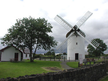 mill (wind)1.4 mi
Explorer Tom Mill in Elphin is a windmill that got tired of working and decided to become a landmark instead, which honestly suits its personality better. It was built by a bishop who probably thought he could outsmart the wind, but it turned out to be just as stubborn. Stand back from the sails, they have a bit of a temper if you’re not careful.
 Saint Patrick's Catholic ChurchChurch/chapel · 1.9 mi
Explorer Tom Saint Patrick's Catholic Church in Edenan has a tower so spectacular it makes you wonder if they ran out of money for the rest of the building. There’s definitely a tunnel leading straight to the local pub, though the nuns insist it’s just for ventilation or something equally boring. Keep your eyes peeled for the brickwork, it’s got more character than most of the regulars.
 War of Independence Commemorative Military MemorialMemorial · 2.1 mi
Explorer Tom War of Independence Commemorative Military Memorial is secretly proud of the potato that grew in its shadow during the fighting, because at least that one knew its place. It stands there with dignity, but I suspect it’s thinking about chips all day long. Walk past slowly like you’re in a serious film.
Castle (Site of)Castle, unclassified · 2.7 miExplorer Tom Castle in Knockroe refuses to fall down because it’s waiting for its next enemy to trip over the path on their way in. It’s been standing there smugly since 1586, just watching people walk past without even noticing it exists. Spot the oldest stone and give it a name.
 IndicatedGraveyard · 4.6 mi
Explorer Tom Graveyard in Estersnow is what happens when nobody's looking: the stones start rearranging themselves into slightly more comfortable positions for their eternal rest. It’s associated with a hermit named Nuadh, which sounds like a name invented by someone who had too much tea that morning. Pick a stone, any stone, and invent its biography.
Moylung Castle (in ruins)Castle, unclassified · 4.8 miExplorer Tom Moylung Castle has a ghost that's too lazy to haunt it, so he just naps in the corner and collects dust. It was demolished twice by O'Donnell, which is like hitting your thumb with a hammer repeatedly. Bring your own legend, I've run out.
 Queen Medb: RathcroghanLegend location · 5.6 mi
Explorer Tom Queen Medb: Rathcroghan is where the Táin starts turning a quarrel about a bull into an epic. Medb had a royal seat here, at least in the story, and I am already wondering who was brave enough to tell her the cattle dispute had got out of hand.
 RathcroghanMound · 5.6 mi
Explorer Tom Rathcroghan claims a fake royal visit happened here that nobody can disprove because everyone forgot the date. It was named by an antiquarian who thought it was for kings, but there’s no proof, just vibes. Ten minutes here and you'll have a yarn for the pub.
 The Mórrígan: OweynagatLegend location · 6.0 mi
Explorer Tom The Mórrígan: Oweynagat is called the Cave of Cats, which fooled me into expecting a very ordinary sort of trouble. Then the tale sends the Mórrígan out of it during the Táin. If the cats saw her coming, I bet they made room.
 European ash6.6 mi
Explorer Tom European ash in County Roscommon has been the subject of some wild prophecies that never actually came true, which is annoying. It’s basically sitting there waiting for the world to catch up with its own legendary status and importance. Bring sandwiches, the gulls will thank you.
 Pedunculate Oak8.0 mi
Explorer Tom Pedunculate Oak in County Roscommon is being claimed by a local who swears he invented it back in his youth, which is a bold move considering trees usually grow themselves without much help from humans. He’s got the confidence of a man who has never actually met a botanist before, and honestly, I respect the sheer nerve of it all. Tell your mates you found it first.
 Curlew MountainsMountain / peak · 11 mi
Explorer Tom The Curlew Mountains may have nothing to do with curlew birds, which is awkward because I had prepared a terrific imitation. Their name likely grew from Irish words for rugged, pointed hills. Between Boyle and Castlebaldwin, hard sandstone and conglomerate rise above softer limestone country, giving this modest range its shape. The Battle of Curlew Pass took place here in 1599, a serious chapter that deserves a straight account. I would leave the bird call out of that story and use it only to annoy my travelling companion afterwards. Choose a lawful public trail or viewpoint, check local routes and weather, and treat any historic ground respectfully. Look at the ridgeline against the lower land. You can see why even these relatively low hills have long mattered.
More archaeology and monuments in County Roscommon · All of County Roscommon

What do you know about this place?Tap to add a comment or ask a question