
Places near here
Photo credits
- National Inventory of Architectural Heritage
- Ryanforsyth9, Wikimedia Commons · CC BY-SA 4.0
- Smirkybec, Wikimedia Commons · CC BY-SA 4.0
- Ian Brooker and David Kleinig, Wikimedia Commons · CC BY 3.0 au
- surrealpenguin, Wikimedia Commons · CC BY-SA 2.0
- Goreymurphy, Wikimedia Commons · CC BY-SA 4.0
- Sarah777 at English Wikipedia, Wikimedia Commons · Public domain
- Sarah777, Wikimedia Commons · Public domain
- liam murphy, Wikimedia Commons · CC BY-SA 2.0
- 瑞丽江的河水, Wikimedia Commons · CC BY-SA 4.0
 Bygones""House · 1415 yd
Explorer Tom Bygones"" is named after a concept of letting go, yet it’s still standing here looking very much like it hasn’t let anything go at all. It makes a funny creaking sound at night that sounds exactly like someone complaining about the weather. Listen for the grumble before you head home.
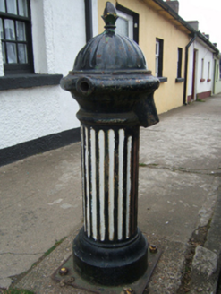 water pump1415 yd
Explorer Tom Vikings once got completely lost looking for this water pump in Gorey because they kept mistaking it for a dragon’s tail. It’s just a hydrant from Kilmarnock, but it stands there like it’s expecting a raid. Look for the dragon tail if you’re brave enough.
 1798 MonumentMemorial · 1494 yd
Explorer Tom This 1798 Monument has an imaginary twin across the sea that they argue about every time the wind picks up from the west. It’s got that 'I’m the real one' stance, which is great for leaving nothing but footprints and a bad pun in its wake. Leave nothing but footprints and a bad pun.
 Market HouseHeritage attraction · 1.1 mi
Explorer Tom Gorey’s Market House is the uncle at a wedding who stands by the cake looking confused about why everyone is dancing while he just wants a quiet drink. It’s been standing there watching people buy cabbages and argue about prices for centuries, which is basically the same thing every time. Take a mate and argue about what it was for.
 Johnston's gum3.1 mi
 Persian Walnut3.8 mi
Explorer Tom Persian Walnut in County Wexford had a fiddler playing all night until the locals threatened to throw rocks at him. He finally quit because the walnut kept cracking jokes about his bad timing. Bring a notebook and write the bit I made up.
 Saint Brigid's WellSpring · 5.3 mi
Explorer Tom Saint Brigid's Well would have a tombstone that says 'She Was Water, But She Never Actually Drowned,' which is technically true but sounds like a very confusing riddle to the uninitiated and probably annoys everyone who reads it. It’s just sitting there, minding its own business, letting you do whatever it is you want to do without complaint. A good place to forget your phone for ten minutes.
 Brides WellHoly well · 5.3 mi
Explorer Tom St. Bridgets Well in Brideswell Big is playing hide-and-seek with me. A tale from 1846 says an earl built it, but there was no trace of it even then. Take a picture for me if you pass!
 Annagh HillMountain / peak · 5.4 mi
Explorer Tom Annagh Hill hosted a fake royal visit where the king turned out to be a local baker in a wig. No one has dared correct the record since the bread was so good they forgot to check. Walk past slowly like you're in a film.
 SlieveboyMountain / peak · 7.3 mi
Explorer Tom Slieveboy thinks it’s much taller than its neighbor Slievecoiltia, even though they’re practically the same height. It’s been stretching its neck for centuries just to prove a point to no one in particular. Get there early and have it all to yourself.
 Saint Mogue's WellSpring · 9.5 mi
Explorer Tom Saint Mogue's Well in Wexford has a local lad who swears he invented the whole concept of holy water right here on this bridge. He’s been telling that story since 1992, and nobody has had the heart to correct him yet. Go now, before it gets famous.
 Ferns Castle (in ruins)Castle, Anglo-Norman masonry castle · 9.7 mi
Explorer Tom Ferns Castle’s secret talent is surviving every single siege by hiding behind a very convincing disguise as a regular hilltop building. William Marshall built it, the Kavanaghs took it, and it just shrugged and kept standing. If anyone asks, Tom sent you.
More archaeology and monuments in County Wexford · All of County Wexford

What do you know about this place?Tap to add a comment or ask a question