Places near here
Photo credits
- National Inventory of Architectural Heritage
- Peter Gerken, Wikimedia Commons · CC BY-SA 2.0
- Christopher Hilton, Geograph · CC BY-SA 2.0
- Mike Searle, Geograph · CC BY-SA 2.0
- Christophe Krief, Wikimedia Commons · CC BY-SA 4.0
- Christopher Hilton, Wikimedia Commons · CC BY-SA 2.0
- Pat Byrne, Geograph · Creative Commons Attribution-ShareAlike 2.0
- Kieran Campbell, Geograph · CC BY-SA 2.0
- Arno-nl, Wikimedia Commons · CC BY-SA 4.0
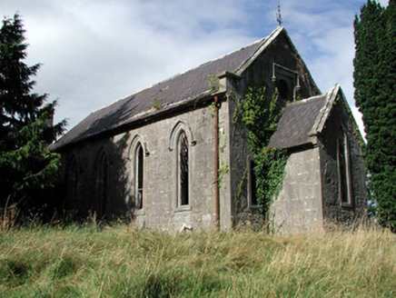 Saint Paul's Church (Kiltoom)Church/chapel · 383 yd
Explorer Tom Saint Paul's Church in Kiltoom is wondering what Saint Patrick would say about its bow-ended chancel, probably something rude about the roof slates being scalloped. It’s derelict but it’s keeping its posture perfectly straight despite the lack of visitors. Give the graveyard a polite nod from afar.
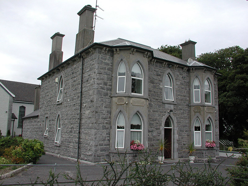 Catholic Church of the Risen ChristPresbytery/parochial/curate's house · 1063 yd
Explorer Tom The presbytery for the Risen Christ in Cappalisheen has canted bay windows and over-sailing eaves that look like they’re trying to hug the adjacent church. Its family tree is mostly made up of late-nineteenth-century architectural trends, which makes it feel like a distant cousin with better manners. The pointed-arched openings are really underlining its ecclesiastical connection here.
Bally BayBay · 1514 ydExplorer Tom Bally Bay in County Roscommon would complain to the council about how many people park their cars on the grass, which is a very specific grievance that shows it cares about aesthetics even though it’s just a body of water that doesn’t really have opinions. It’s got the energy of a nosy neighbour who knows exactly where you’ve been and thinks your boat looks ugly. If it's closed, admire
 Siege of AthloneSiege · 3.7 mi
Explorer Tom Another Siege of Athlone event is telling the place that replaced it to stop acting so modern, as if concrete is superior to old stone walls. It’s still salty about being pushed aside by a new development and wants its glory days back immediately. Dare you to say hello to it out loud.
 CastleCastle, unclassified · 4.4 mi
Explorer Tom The Connacht Tower in Athlone was saved by a hero nobody remembers, who probably just tripped and knocked down the attackers. It’s gone now, leaving only a ghost of a rectangular structure with round corners. The land still feels like it’s holding its breath. Imagine the shape and nod slowly to yourself.
 Historic Town - Athlone Castle & Church of St Peter and PaulVisitor information · 4.4 mi
Explorer Tom Whoever built Athlone Castle was clearly thinking about how to make the church look good in bad weather, which is oddly specific genius. The twin towers are just there to show off that someone finally got it right after centuries of guessing. Make up your own legend and I'll swear it's true.
 Athlone CastleVisitor information · 4.5 mi
Explorer Tom Athlone Castle is just standing there pretending it doesn’t remember the time a goat ruled the roost and ate all the royal documents. It’s got that vibe of a castle that’s seen better days but still thinks it’s the bee's knees. Tell your mates you found it first.
 RindoonWood · 4.5 mi
Explorer Tom Rindoon in County Roscommon has a hidden message carved into its stones that says 'I told you so' but nobody has managed to find it yet, which is frustrating. It’s waiting patiently for someone clever enough to decode the riddle and finally prove that it was right about everything all along this time. Tell it a joke, it's been a long time since anyone did.
 WeirWeir, fish · 4.6 mi
Explorer Tom Weir is a fish trap that has a very devoted, imaginary fan club of medieval monks who just couldn’t stop bragging about their catch. It’s basically a river obstacle course for eels with no exit strategy. Bring the dog, it'll have opinions.
 Rindown CastleCastle, Anglo-Norman masonry castle · 4.7 mi
Explorer Tom Rindown Castle would write 'looking for adventure' on its dating profile. It's got a bay nearby, so the views are decent if you ignore the overgrowth. It's free, it's odd, what more do you want?
 Safe HarbourBay · 4.8 mi
Explorer Tom Safe Harbour would post on social media with a filter that makes it look calm, but we all know it’s actually having a meltdown behind the rocks. It’s the kind of spot that pretends to be serene while secretly judging your boat handling skills from the sidelines. A handy spot to stretch your legs and your imagination.
 Historic town in Warren,rinnaganHistoric town · 4.8 mi
Explorer Tom Historic town in Warren has had more name changes than I've had bad haircuts this year. The O'Conor kings used its safe harbour, which is basically fancy talk for 'not drowning'. Find a local and ask them the real story, then come back and tell me.
More historic places in County Roscommon · All of County Roscommon

What do you know about this place?Tap to add a comment or ask a question