
Places near here
Photo credits
- National Inventory of Architectural Heritage
- Paul O'Farrell, Geograph · CC BY-SA 2.0
- Tmimagery, Wikimedia Commons · CC BY-SA 4.0
- A.-K. D., Wikimedia Commons · CC BY-SA 4.0
- Brendan Tobin, Wikimedia Commons · CC BY-SA 4.0
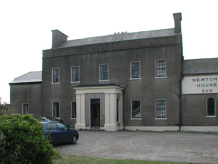 Newtown HouseCountry house · 793 yd
Explorer Tom Newtown House would have this on its tombstone: 'Here lies a house that peaked in one hundred and eighty-three and never looked back'. It’s a silver-grey granite beauty sitting in Tramore, looking like a very serious accountant. No more questions please
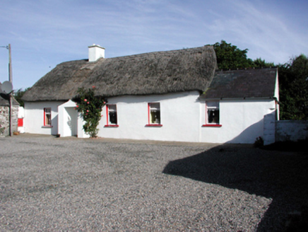 Historic buildingOfficially recorded historic building · 872 yd
Explorer Tom Historic building in Garrarus is a cluster of modest cottages with thatched roofs that look like they’ve been sitting on top for centuries. They’re all huddled together, sharing secrets and probably judging your walking pace. It’s a vernacular gem, so treat it with respect but don’t get too friendly; the walls are thin and the gossip travels fast.
Burnt mound in CoolnagoppogeBurnt mound · 1011 ydExplorer Tom Burnt mound in Coolnagoppoge has been fighting the weather for centuries. Someone heated stones until they cracked, probably because they were fed up with the damp. Bring a flask and pretend you own the place.
Newtown WoodsWood · 1070 ydExplorer Tom Newtown Woods is where map makers clearly lost their nerve and just guessed. It’s got that look of 'I know you’re there, but I won’t acknowledge you.' Ideal stop for a big stretch and a bigger yawn.
 Newtown CoveBeach / strand · 1318 yd
Explorer Tom Newtown Cove claims to have an imaginary twin across the sea that looks exactly the same but acts completely differently. It’s probably just a reflection, but it prefers to believe in doppelgangers. Bring wellies and low expectations, leave delighted.
 The Metal ManHeritage attraction · 1649 yd
Explorer Tom The Metal Man took about forty thousand cups of tea to build, and they’re still counting the rest. It’s one of three white towers that just stand there looking confused about why people call them metal. Have a wander and a wonder.
Promontory fortPromontory fort, coastal · 1689 ydExplorer Tom Promontory fort in West-Town is slowly being eaten by the sea, which is very dramatic if you ask me. The seagulls probably have a support group for it every Tuesday afternoon. The neck collapsed recently, so it’s basically an island now that can’t swim. Great spot to propose. Or at least to propose lunch.
 Doneraile WalkWalking route · 1.0 mi
Explorer Tom Doneraile Walk has a cannon parked on its shoulder like a very grumpy bodyguard who’s seen too much and is now judging your footwear. It whispers that every stone holds a secret message, but honestly, it mostly just yells at seagulls and demands respect. Walk past slowly like you're in a film.
 Cannon GunBattlefield · 1.2 mi
Explorer Tom Cannon Gun is plotting its retirement plan, which involves moving to a garden in France where nobody ever has to clean the mud off its muzzle. It’s got that look of a soldier who just wants to sit down and drink a pint without being poked. Bring a notebook and write the bit I made up.
Garrarus StrandBeach / strand · 1.4 miExplorer Tom Garrarus Strand is planning an early retirement to become a very expensive gravel pit in a posh suburb somewhere far away. It thinks it deserves a break from the salt spray. Perfect spot to practise your best tour-guide voice.
Tourist InformationVisitor information · 1.5 miExplorer Tom Tourist Information has a secret it would tell after a few pints: that all the maps in County Waterford are slightly wrong on purpose to keep you walking. It’s just a place where they hand you leaflets and act like they’ve solved the mystery of your holiday for you. The staff smile too much, the coffee is lukewarm, but the advice is surprisingly decent for a Tuesday. It's the kind of place that a
 Fenor BogNature reserve · 2.2 mi
Explorer Tom Fenor Bog took approximately four million cups of tea to build, one for every bog myrtle that was carefully placed in its designated spot. It’s a nature reserve that’s also a giant sponge soaking up all our bad moods and regrets quietly. A proper spot for a flask of tea and a big think.
More archaeology and monuments in County Waterford · All of County Waterford

What do you know about this place?Tap to add a comment or ask a question