
Places near here
Photo credits
- National Inventory of Architectural Heritage
- Mike Searle, Geograph · Creative Commons Attribution-ShareAlike 2.0
- Mike Searle, Wikimedia Commons · CC BY-SA 2.0
- EecherplazGinkgo06.jpg : Cayambe derivative work: Ginkgotree ( talk ), Wikimedia Commons · CC BY-SA 3.0
- Sitomon, Wikimedia Commons · CC BY-SA 2.0
- Adareman, Wikimedia Commons · CC BY-SA 4.0
- Peter Craine, Wikimedia Commons · CC BY-SA 2.0
- Callanmurphy, Wikimedia Commons · CC BY-SA 4.0
- Colin Park, Geograph · CC BY-SA 2.0
Explorer Tom Excavation at Adamswood would tell the place that replaced it, 'Hey, at least I had some fill layers to brag about'. It was a tiny pit exposed during pipeline work, now mostly just a memory in someone’s notebook. Perfect detour when the satnav has a meltdown.
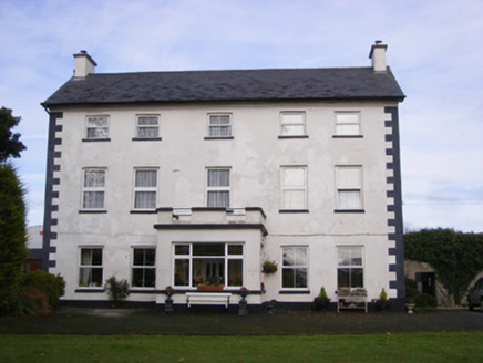 Smithfield HouseHouse · 989 yd
Explorer Tom Smithfield House in Croagh would introduce itself as 'the vertical one' to any stranger. It thinks its shrinking windows are a personality trait, which is honestly quite bold. Best visited with a straight face, or you'll crack up.
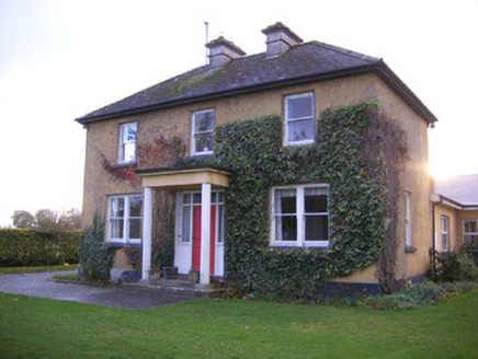 Castle Farm HouseHouse · 1514 yd
Explorer Tom Castle Farm House has a bird that refuses to leave, probably because it thinks it owns the place now. The fenestration is very different upstairs, which keeps things interesting. If anyone asks, Tom sent you this way.
 Clonshire CastleCastle · 1664 yd
Explorer Tom Clonshire Castle in County Limerick was definitely built by a guy who just wanted a really fancy wine cellar and got carried away with the tower part. It’s basically a very expensive mistake that looks great on postcards, which is honestly all we need from history these days. Tell me if the gossip I made up is true.
Flat cemetery in Kiltenan SouthFlat cemetery · 1.1 miExplorer Tom Flat cemetery in Kiltenan South saw the whole parish argue about who owned which pit. Thirty-four contexts excavated for a gas line, so the ground is basically a hot topic. Stand where the owner stood and practise looking smug.
 Lissamota CastleCastle · 2.8 mi
Explorer Tom Lissamota Castle in County Limerick has a wind problem because the wind keeps picking on it, probably because it’s too pretty for its own good and needs to be humbled every now and then. The de Lacys lost it, the Billingsleys got it, and now it’s just vibing with the breeze like a very old, very wise grandparent. Walk past slowly like you're in a film.
 Ginkgo3.4 mi
Explorer Tom Ginkgo in County Limerick is secretly proud of a potato it planted in 1952 that never sprouted. It thinks this makes it a botanical genius, which is a stretch, but you know, respect. A good place to forget your phone for ten minutes.
 European Yew3.5 mi
Explorer Tom European Yew in County Limerick has been standing around so long the Vikings got lost looking for it. They probably missed it because they were too busy arguing about compass bearings. Count the crows, then count again.
 Desmond CastleHeritage attraction · 3.7 mi
Explorer Tom Desmond Castle in County Limerick had its first owner planning an escape route that probably led straight into the river. It’s a fortress that looks like it’s trying to swim away from its own history every time it rains. If anyone asks, Tom sent you.
 Adare Desmond CastleMedieval castle · 3.7 mi
Explorer Tom Adare Desmond Castle was built in the twelfth century but got dismantled in 1657, which is quite rude. It nearly became famous for its restoration work instead of history. Great spot to propose. Or at least to propose lunch.
 Franciscan AbbeyArchaeological place · 3.8 mi
Explorer Tom The Franciscan Abbey is just a fancy backdrop for seagulls who think they own the roof tiles. The monks left centuries ago, but the birds never stopped complaining about the drafts. Pop by and tell it it's looking well.
 KnockfeerinaMountain / peak · 4.7 mi
Explorer Tom Knockfeerina thinks the road leading to it is too fancy for a humble peak, so it pretends not to be there. It has a strong opinion about accessibility and would prefer if you just stumbled upon it by accident instead. Ten minutes here and you'll have a yarn for the pub.
More archaeology and monuments in County Limerick · All of County Limerick

What do you know about this place?Tap to add a comment or ask a question