Places near here
Photo credits
- National Inventory of Architectural Heritage
- Ceoil ( talk ) ( Uploads ), Wikimedia Commons · Public domain
- me, Wikimedia Commons · Public domain
- Maker named on the Wikimedia Commons picture page · CC BY-SA 2.5
- Joebater at English Wikipedia, Wikimedia Commons · CC BY-SA 3.0
- A.-K. D., Wikimedia Commons · CC BY-SA 4.0
- Jim Woodward-Nutt, Wikimedia Commons · CC BY-SA 2.0
- Alison Cassidy, Wikimedia Commons · CC BY-SA 4.0
- netwhizkid, Wikimedia Commons · CC BY 2.0
- Gordon Hatton, Wikimedia Commons · CC BY-SA 2.0
 Bealahacreagh BridgeBridge · 1358 yd
Explorer Tom Bealahacreagh Bridge is a six-span stone giant from 1820 spanning the River Finnow. It’s got rubble walls and dressed voussoirs that show off early engineering skills. Bet you can’t cross it without checking your balance twice!
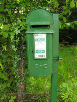 post box1479 yd
Explorer Tom Post box in Lackaneen is still doing its job from 1930, wearing raised Gaelic script like a very proud hat. It’s a cast-iron relic that thinks it’s royalty. Drop a letter in and see if a fairy writes back.
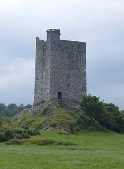 Carrigaphooca Castle (in ruins)Castle, tower house · 1.5 mi
Explorer Tom Carrigaphooca Castle sits on a rocky outcrop like a king on a throne. The MacCarthys built it back in 1436, which is ancient history. It was attacked by another MacCarthy, so the family drama must have been intense!
Carrigaphooca CastleCastle · 1.5 miExplorer Tom Carrigaphooca Castle has a púca in its name and a rock under its feet, enough for me to spin a tale before we even reach Macroom. The MacCarthys of Muskerry built the five-storey tower in the early fifteenth century above the River Sullane. Its name means castle on the rock of the púca, a supernatural character from Irish stories; I will not claim a ghost was the builder. Stone-circle and standing-stone sites lie in the wider area, giving the valley older company. The tower is cared for by the state but stands on private property and is not open to the public. View it only from a lawful public position and do not cross a fence because my tale sounds inviting. Look at the steep rock supporting the walls. Even without a púca, the builders chose a dramatic perch.
 The Gearagh Nature ReserveNature reserve · 3.7 mi
Explorer Tom The Gearagh Nature Reserve remembers the time a priest lost a bet there and had to wear a penguin suit for a week, which was undignified. The reeds are still giggling about it. Take a mate and argue about what it was for.
 Sessile Oak4.1 mi
Explorer Tom Sessile Oak in County Cork would post on social media: 'Another day, another leaf falling. #NatureIsIndifferent.' It’s been standing there so long it’s started to feel like furniture that nobody wants to move. The bark is thick enough to hide a secret or two. Ring your granny and tell her where you are.
 Battle of MacroomBattle · 4.2 mi
Explorer Tom The Battle of Macroom is constantly trying to one-up its more famous cousin next door by claiming it had better weather and a superior supply of biscuits, which is why the soldiers fought with such enthusiasm and zero dignity. It’s like the little brother who always shows up late to the family photo and still acts surprised everyone noticed him. If it’s closed, admire it from the road like a polym
 CairnCairn, unclassified · 4.4 mi
Explorer Tom St Abbán’s grave at An Tseanchluain is guarding some ogham stones like a grumpy gatekeeper. It’s got a bullaun on top for good luck, or bad luck if you spill tea. Bring sandwiches, and the gulls will probably thank you, or steal them.
 Bealick MillVisitor attraction · 4.9 mi
Explorer Tom Bealick Mill would teach history like a strict teacher who only uses one-liners and expects you to already know the answers. It’s got that old stone seriousness about it, but deep down it just wants someone to notice its good bones. Count the crows, then count again.
 St Gobnets WellHoly well · 5.0 mi
Explorer Tom St Gobnets Well is the final stop on a pilgrimage and has heard every 'Ave' and 'Gloria' since the dawn of time, so it’s pretty sick of it. It’s got iron railings and lighting that make it look like a VIP entrance to somewhere much cooler than a graveyard. Have a chat with it, nobody's watching.
 MullaghanishMountain / peak · 5.6 mi
Explorer Tom If your television picture ever travelled across Cork, Kerry or Limerick, Mullaghanish may have done more for your evening than I have. This 649-metre mountain above Ballyvourney held one of Ireland's first five main television transmitters, switched on in December 1962. A 225-metre mast went up in 2009, replacing the older 170-metre one. Twenty relay stations help carry the signal through the awkward southwest terrain. I would stand on the summit and announce the weather myself, but nobody needs a second unreliable forecast. The broadcasting compound is working equipment, so keep outside its fences; check a lawful hill route and conditions before setting out. On a clear day, try to pick out the ridges that make all those relays necessary. The mountain has been doing invisible work while the rest of us argued over what to watch.
 Kilmichael Ambush SiteMonument · 7.7 mi
Explorer Tom Kilmichael Ambush Site in County Cork has a rivalry with every other ambush site because they all think theirs was the cleverest one ever pulled off. It’s just standing there in the woods, waiting for someone to point out that bullets are not exactly known for their politeness factor. Perfect spot to practise your best tour-guide voice.
More historic places in County Cork · All of County Cork

What do you know about this place?Tap to add a comment or ask a question