
What is recorded here
Located in deep water towards the SW end of Clooncorick Lough, a subrectangular lake (dims c. 550m NE-SW; c. 140-250m NW-SE), which is slightly smaller than its representation on the 1835 edition of the OS 6-inch map. This is an overgrown, circular, steep-sided, earth and stone island (diam. 17.5m; H 1.5m) surrounded…
Read the whole record
From the National Monuments Service (Archaeological Survey of Ireland) record LE030-031
Places near here
Picture notes
- Computer-made picture. It does not show this monument.
- Computer-made picture. It does not show this mountain top.
- National Inventory of Architectural Heritage
- Sitomon, Wikimedia Commons · CC BY-SA 2.0
- Algirdas at Lithuanian Wikipedia, Wikimedia Commons · Public domain
- Computer-made picture. It does not show this playground.
- Computer-made picture. It does not show this walking route.
 Man-made underground passage in ClooncorickMan-made underground passage · 432 ydTom: I’m here to help · Computer-made picture. It does not show this monument.
Explorer Tom Man-made underground passage in Clooncorick has caught my eye in Clooncorick, County Leitrim. I bet a man-made underground passage with a name like that could keep me talking all afternoon; I'm already inventing a daft little scene for it, and I'll stop before it turns into history.
 Mound in ClooncorickMound · 432 ydTom: I’m here to help · Computer-made picture. It does not show this monument.
Explorer Tom Mound in Clooncorick has caught my eye in Clooncorick, County Leitrim. I bet a mound with a name like that could keep me talking all afternoon; I'm already inventing a daft little scene for it, and I'll stop before it turns into history.
 King's GraveArchaeological place · 630 yd
Explorer Tom King's Grave has caught my eye in County Leitrim. I bet a archaeological place with a name like that could keep me talking all afternoon; I'm already inventing a daft little scene for it, and I'll stop before it turns into history.
 DrumsillaghMountain / peak · 852 ydTom: I’m here to help · Computer-made picture. It does not show this mountain top.
Explorer Tom Drumsillagh has caught my eye in County Leitrim. I bet a mountain / peak with a name like that could keep me talking all afternoon; I'm already inventing a daft little scene for it, and I'll stop before it turns into history.
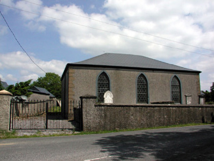 Carrigallen Presbyterian ChurchChurch/chapel · 1201 yd
Explorer Tom Carrigallen Presbyterian Church has caught my eye in Kivvy, County Leitrim. I bet a church/chapel with a name like that could keep me talking all afternoon; I'm already inventing a daft little scene for it, and I'll stop before it turns into history.
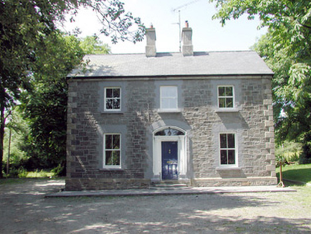 The ManseManse · 1394 yd
Explorer Tom The Manse has caught my eye in Clooncorick, County Leitrim. I bet a manse with a name like that could keep me talking all afternoon; I'm already inventing a daft little scene for it, and I'll stop before it turns into history.
 European Yew1.2 mi
Explorer Tom European Yew has caught my eye in County Leitrim. I bet a european yew with a name like that could keep me talking all afternoon; I'm already inventing a daft little scene for it, and I'll stop before it turns into history.
 Pedunculate Oak1.2 mi
Explorer Tom Pedunculate Oak has caught my eye in County Leitrim. I bet a pedunculate oak with a name like that could keep me talking all afternoon; I'm already inventing a daft little scene for it, and I'll stop before it turns into history.
 PortlongfieldMountain / peak · 1.8 miTom: I’m here to help · Computer-made picture. It does not show this mountain top.
Explorer Tom Portlongfield might mark the edge of an old pasture in County Cavan, where the land opens up into rolling green hills.
BatteryBawn · 4.7 miExplorer Tom Battery has caught my eye in Crane Island, County Leitrim. I bet a bawn with a name like that could keep me talking all afternoon; I'm already inventing a daft little scene for it, and I'll stop before it turns into history.
 Children's playground4.8 miTom: I’m here to help · Computer-made picture. It does not show this playground.
Explorer Tom Here, a Children's playground in County Cavan might be where local legends are born, one brave jump at a time.
 Killeshandra LoopWalking route · 5.2 miTom: I’m here to help · Computer-made picture. It does not show this walking route.
Explorer Tom Killeshandra Loop is a recorded walking route, perfect for a circular wander through the lovely local landscape.
More archaeology and monuments in County Leitrim · All of County Leitrim
What do you know about this place?Tap to add a comment or ask a question