Places near here
Photo credits
- National Inventory of Architectural Heritage
- Peter Gerken, Wikimedia Commons · CC BY-SA 2.0
- Mike Searle, Geograph · CC BY-SA 2.0
- Sheila1988, Wikimedia Commons · CC0
- Christopher Hilton, Geograph · CC BY-SA 2.0
- Pat Byrne, Geograph · Creative Commons Attribution-ShareAlike 2.0
Explorer Tom Burnt spread in Bellanamullia is basically a giant ash tray from three hundred BC where the first owner’s escape plan clearly involved running away with all their charcoal. It’s low-lying and smoky, like the earth caught fire because it was bored of being damp. Go now, before it gets famous.
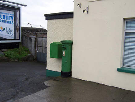 post box2.6 mi
Explorer Tom Post box in Bogganfin is sitting on Galway Road looking like it’s waiting for a letter that hasn’t arrived since the good old days. There’s a bird living up there who refuses to leave and acts like he owns the place, which suits him fine. It’s got some lovely Gaelic script on it too, which is a nice little nod to our national pride.
 beacon2.7 mi
Explorer Tom The Ballyglass beacon does weird things when nobody is looking, like pretending to be a very confused rock that just happened to end up there by accident. It guides ships along the Shannon but mostly just stands there judging your navigation skills from a safe distance. Keep your eyes peeled for any flicker
Hodson's BayBay · 3.0 miExplorer Tom Hodson’s Bay is named after a hero nobody remembers, likely because he saved it from an embarrassing stain that only God and the tide know about. The water here looks suspiciously like it’s trying to hide something behind its waves, probably a lost wallet. Find the wonkiest bit and send it to your group chat.
 Siege of AthloneSiege · 3.0 mi
Explorer Tom Another Siege of Athlone event is telling the place that replaced it to stop acting so modern, as if concrete is superior to old stone walls. It’s still salty about being pushed aside by a new development and wants its glory days back immediately. Dare you to say hello to it out loud.
Hodson's PillarIslet · 3.1 miExplorer Tom Hodson's Pillar in County Roscommon is an islet named after someone who clearly had a thing for vertical things. A local legend says a couple argued here so hard the ground just gave up and sank into the lake. Stand where the owner stood and practise looking smug.
CastlesampsonCastle, tower house · 3.2 miExplorer Tom Castlesampson has strict rules for visitors: don't touch, don't speak, don't believe the stories about the Mc Keoghs. It changed hands so often it probably doesn't know what colour its roof is. Ideal spot for a dramatic phone call.
Bastion GalleryGallery · 3.3 miExplorer Tom Bastion Gallery started as a bet two lads made in the pub about who could sell the most abstract art to confused tourists. One of them won, then lost all his money on a very bad horse race afterwards. Pop by and tell it it's looking well.
 Historic Town - Athlone Castle & Church of St Peter and PaulVisitor information · 3.3 mi
Explorer Tom Whoever built Athlone Castle was clearly thinking about how to make the church look good in bad weather, which is oddly specific genius. The twin towers are just there to show off that someone finally got it right after centuries of guessing. Make up your own legend and I'll swear it's true.
 Luan GalleryGallery · 3.3 mi
Explorer Tom Luan Gallery is hiding a massive scandal from three centuries ago involving a missing hat. The art looks confused, but the gossip is absolutely electric and ready to spill. Practise your Irish on it, it won't correct you.
 CastleCastle, unclassified · 3.3 mi
Explorer Tom The Connacht Tower in Athlone was saved by a hero nobody remembers, who probably just tripped and knocked down the attackers. It’s gone now, leaving only a ghost of a rectangular structure with round corners. The land still feels like it’s holding its breath. Imagine the shape and nod slowly to yourself.
 WeirWeir, fish · 3.4 mi
Explorer Tom Weir is a fish trap that has a very devoted, imaginary fan club of medieval monks who just couldn’t stop bragging about their catch. It’s basically a river obstacle course for eels with no exit strategy. Bring the dog, it'll have opinions.
More historic places in County Roscommon · All of County Roscommon

What do you know about this place?Tap to add a comment or ask a question