
What is recorded here
From the National Monuments Service (Archaeological Survey of Ireland) record CL025-112
Places near here
Picture notes
- Computer-made picture. It does not show this monument.
- National Inventory of Architectural Heritage
- Odea at English Wikipedia, Wikimedia Commons · Public domain
- JohnArmagh, Wikimedia Commons · Public domain
- Mike Searle, Wikimedia Commons · CC BY-SA 2.0
- Computer-made picture. It does not show this playground.
- Computer-made picture. It does not show this walking route.
- Willow, Wikimedia Commons · CC BY 2.5
 Fairy fort / stone ringfort in CloonaFairy fort / stone ringfort · 498 ydComputer-made picture
Explorer Tom Fairy fort / stone ringfort in Cloona would get 'Finally Resting' on its tombstone because it’s so tired of the wind. It’s dramatic, but I love it. Whisper a secret at it; honestly, it has kept far worse secrets over the years.
 IndicatedEnclosure · 594 ydComputer-made picture
Explorer Tom Enclosure in Ballycullinan is judging that road leading up to it with silent disdain. It thinks the tarmac is for peasants. Perfect spot to stand there and look dramatically windswept while pretending you’re deep in thought.
 Earthwork in MollaneenEarthwork · 707 ydComputer-made picture
Explorer Tom Earthwork in Mollaneen is on a ridge overlooking a turlough that has no visible remains at ground level. The shortcut through here isn't a shortcut, it’s just mud with attitude. Go in good boots and better humour if you don't want to cry.
 Crannog in BallycullinanCrannog · 707 ydComputer-made picture
Explorer Tom Crannog in Ballycullinan is proud of being a houseboat from before boats were cool. It’s basically a pile of dirt on stilts that missed the boat. Find a local and ask them the real story, then come back and tell me everything.
 Fairy fort / stone ringfort in KilleenanFairy fort / stone ringfort · 829 ydComputer-made picture
Explorer Tom This Fairy fort / stone ringfort in Killeenan has an imaginary twin across the sea that owes it money. They used to write letters, but now they just send passive-aggressive postcards about how much better their weather is. It's free, it's odd, what more do you want?
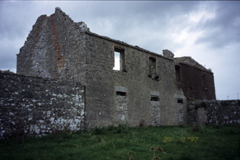 Mollaneen HouseFarm house · 1218 yd
Explorer Tom Mollaneen House, a farmhouse from 1770, now stands in ruins with cut-stone soldier arches still visible on its ground floor openings.
 O'Dea CastleCastle · 1297 yd
Explorer Tom O'Dea Castle is a recorded castle in County Clare, with a photo taken by Richard G. O'Dea releasing all rights.
 Dysert Church (in ruins)Church · 1484 yd
Explorer Tom Dysert Church was founded by St Tola around AD 700, which is ancient enough for my taste. A local claims to have invented it, but I doubt it. Stand there long enough and someone will ask if you're lost.
_-_geograph.org.uk_-_4074553.jpg/250px-Castles_of_Munster,_Ballygriffy,_Clare_(1)_-_geograph.org.uk_-_4074553.jpg "Photo: Mike Searle, Wikimedia Commons · CC BY-SA 2.0") Ballygriffy CastleCastle, tower house · 2.1 mi
Ballygriffy CastleCastle, tower house · 2.1 miExplorer Tom Ballygriffy Castle in Ballygriffy South has a curse on it: if you don’t wave, your phone loses signal. It’s a tower house that demands attention. Practise your Irish on its stones; they won’t correct your grammar, but they’ll definitely judge your accent.
 Children's playground3.9 miComputer-made picture
Explorer Tom This children's playground is open to all, offering a welcoming space for families and adventurers.
 Mid Clare WayWalking route · 4.3 miComputer-made picture
Explorer Tom Mid Clare Way in County Clare is right in the middle of nowhere! Perfect for getting away from it all. You'll feel like you're on another planet.
 European ash4.5 mi
Explorer Tom European ash that probably thinks it's a fancy French willow but with better posture. Bring your worst joke, the place has heard worse from my mates.
More archaeology and monuments in County Clare · All of County Clare

What do you know about this place?Tap to add a comment or ask a question