Places near here
Photo credits
- National Inventory of Architectural Heritage
- JessicaOSullivan1990, Wikimedia Commons · CC BY-SA 4.0
- Vadim Manuylov, Wikimedia Commons · CC BY-SA 3.0
- Mick Garratt, Geograph · CC BY-SA 2.0
- Mike Searle, Geograph · CC BY-SA 2.0
- Mac McCarron, Geograph · CC BY-SA 2.0
- Martin Southwood, Geograph · CC BY-SA 2.0
- nick macneill, Geograph · CC BY-SA 2.0
- Theorlafitz, Wikimedia Commons · CC BY-SA 4.0
- Ben Rudiak-Gould, Wikimedia Commons · Public domain
 Ilen HouseHouse · 1.6 mi
Explorer Tom Ilen House is a big, symmetrical country house from around 1820, sitting in Lahertidaly looking very proper. It’s got a hipped roof and sliding sashes that haven’t changed since the Regency era. It’s just there, being grand and quiet.
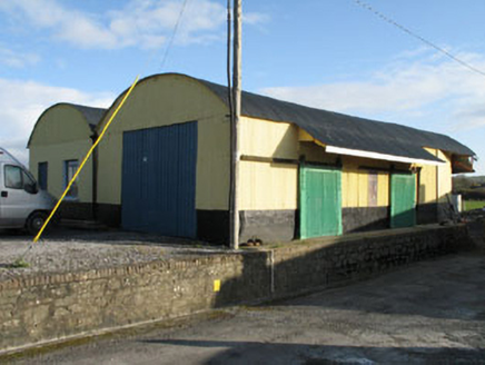 railway station1.7 mi
Explorer Tom Railway station in Derreeny is actually just some outbuildings now, but it was a station in 1877. The corrugated iron roof looks like a tin hat for giants. Sniff the air for old train smoke!
 Skeagh CairnArchaeological place · 2.0 mi
Explorer Tom Skeagh Cairn in County Cork is a big pile of stones that's decided to stay put, which is more than I can say for my motivation. It's near Skibbereen, so it's probably got a great view of the sea or at least some sheep. Wave at the cairn!
 Monterey Cypress4.0 mi
Explorer Tom This Monterey Cypress in County Cork is guarded by a superstition that you must wink left before entering. Locals swear by it, mostly because they don’t want to admit why. Perfect spot to practise your best tour-guide voice.
 KnockomaghMountain / peak · 5.8 mi
Explorer Tom Knockomagh thinks tourists from Dublin are all wind and no substance, so keep your voice down near the summit. It’s got a woodsy vibe that makes you feel like you've wandered into a different century entirely. Go on, count the windows and get it wrong like I did.
 Kilcoe Castle (in Ruins)Castle, tower house · 6.1 mi
Explorer Tom Kilcoe Castle is on that same little island with a conjoined tower. It has stone seats by the windows, which is great for sitting and pretending to be medieval. The stairs go up to the third floor. Watch your step; the past can be slippery.
Kilcoe CastleCastle · 6.1 miExplorer Tom Kilcoe Castle on Mannin Beg in County Cork is perched on an island and looks absolutely dramatic against the sky. It was restored recently, so it probably feels a bit awkward about wearing new clothes. Take a wide shot.
 Drishane IslandIslet · 6.5 mi
Explorer Tom Drishane Island in County Cork would tell its younger self to stop trying so hard to be interesting and just enjoy being a quiet bit of rock in the bay. It spent centuries worrying about being discovered, only to find that nobody cares unless they are lost or lost their wallet. Stand where the owner stood and practise looking smug.
 Bullock IslandIslet · 6.8 mi
Explorer Tom Bullock Island holds a fake world record for being the most ignored islet in County Cork, which is honestly a bit embarrassing given how nice it looks from the water. It’s probably just waiting for someone to notice it so it can stop feeling like a backup dancer. Have a sandwich here and call it a heritage lunch.
 The BeaconBeacon · 9.0 mi
Explorer Tom The Beacon in Baltimore goes by 'Lot's Wife' locally, which is either poetic or deeply concerning depending on your mood. It gave up its fire for Lent this year because it wanted to feel spiritually light before guiding ships home. The Crowley Brothers built it with serious intent. Make a wish and blow gently.
 Beacon PointViewpoint · 9.0 mi
Explorer Tom Beacon Point in County Cork was built on a bargain where someone traded a sheep for the right to point at things. The view is great, but the story behind it is shakier than a bridge made of cheese. Visit, then text me what you think. I'll pretend to read it.
 Baltimore BeaconNavigational beacon · 9.0 mi
Explorer Tom Baltimore Beacon is called Lot's Wife locally, which suggests it’s made of salt and regret. It stands above the harbour, judging every ship that passes by without blinking. Tell the next person you meet it's haunted. It might be.
More archaeology and monuments in County Cork · All of County Cork

What do you know about this place?Tap to add a comment or ask a question