
What is recorded here
From the National Monuments Service (Archaeological Survey of Ireland) record CO039-043
Places near here
Photo credits
- National Inventory of Architectural Heritage
- Maker not stated on source page, au.pinterest.com
- Maker not stated on source page, commons.wikimedia.org
- Jonathan Thacker, Geograph · CC BY-SA 2.0
- Maker not stated on source page, www.tripadvisor.ca
- Maker not stated on source page, www.dreamstime.com
- Kmcnamee, Wikimedia Commons · CC BY-SA 4.0
 Inchileigh BridgeBridge · 619 yd
Explorer Tom Inchileigh Bridge in Coomlogane is a single-arch limestone bridge over the River Finnow from around 1810. It’s got…
 Inch HouseHouse · 684 yd
Explorer Tom Inch House in Coomlogane is a big 1910 show-off with a hipped roof and wide eaves. It’s got a porch and bay windows…
 Ogham stone (present location) in CoomloganeOgham stone (present location) · 859 yd
Explorer Tom Ogham stone in Coomlogane number two was also a lintel and used to hide its inscription when it was in place. Now it…
 Duggan Park, MillstreetGAA ground · 1044 yd
 St. Patrick's ChurchVisitor information · 1079 yd
Explorer Tom St. Patrick's Church has an ongoing feud with the rain because it keeps getting wet and grumpy. The building looks like…
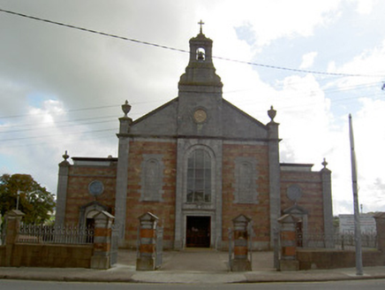 Saint Patrick's Catholic ChurchChurch/chapel · 1136 yd
Explorer Tom Saint Patrick's Catholic Church in Coomlogane is the town’s most accomplished historic building, which is doing a lot…
 Church in Claragh MoreChurch · 1225 yd
Explorer Tom Church in Claragh More in Cork is basically invisible because there are no signs left at all. The locals call it 'The…
 Fairy fort / earthen ringfort in LiscreaghFairy fort / earthen ringfort · 1287 yd
Explorer Tom This Fairy fort / earthen ringfort in Liscreagh is on the edge of a sharp drop with a jagged scarp. The owner knocked…
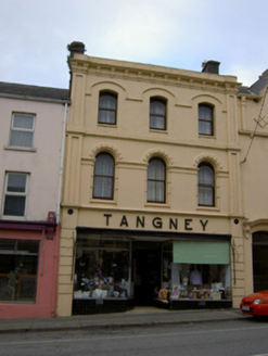 TangneyHouse · 1353 yd
Explorer Tom Tangney in Liscahane has shamrock motifs on the windows that are trying too hard to be Irish. It’s a shop now, but the…
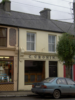 C. CroninHouse · 1355 yd
Explorer Tom C. Cronin in Liscahane is a shop front with cast-iron lettering from the 1930s, spelling out Cornelius Cronin's name.…
 St. John's GAA pitchGAA ground · 1457 yd
 Claragh MountainMountain / peak · 1.1 mi
Explorer Tom Claragh Mountain rises behind Millstreet in County Cork, close enough to town that Tom thought the summit might accept…
More archaeology and monuments in County Cork · All of County Cork

What do you know about this place?Tap to add a comment or ask a question