Places near here
Photo credits
- National Inventory of Architectural Heritage
- Ceoil at English Wikipedia, Wikimedia Commons · CC BY-SA 3.0
- Michael Earnshaw, Geograph · CC BY-SA 2.0
- Jonathan Thacker, Wikimedia Commons · CC BY-SA 2.0
- Jim Woodward-Nutt, Wikimedia Commons · CC BY-SA 2.0
- Garry Dickinson, Wikimedia Commons · CC BY-SA 2.0
- Joebater at English Wikipedia, Wikimedia Commons · CC BY-SA 3.0
- Donald MacDonald, Geograph · CC BY-SA 2.0
- Colin Park, Geograph · Creative Commons Attribution-ShareAlike 2.0
- Sole Origami, Wikimedia Commons · CC BY-SA 4.0
Explorer Tom Clonavrick Cliff means 'The Place Where You Might Slip If You’re Not Careful,' which is basically the whole vibe of the place. It’s got that dramatic edge that makes you feel like an action hero for a second. Bring a flask and pretend you own the place.
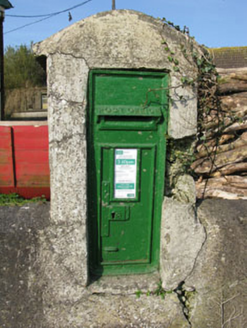 post box1.1 mi
Explorer Tom Post box in Bawnmore is a cast-iron secret keeper from the late nineteenth century. It’s been hiding scandals since before Wi-Fi existed. Twist: give it a wink if you think it knows where your missing socks are.
 kiln2.0 mi
Explorer Tom Kiln in Coolaniddane is an 1820s limekiln that’s been sitting by the roadside doing nothing for ages. It’s got limestone walls and a segmental arch that remind you of when people were burning rock for fun, or at least for mortar.
 Carrigagulla Stone CircleArchaeological place · 2.6 mi
Explorer Tom Carrigagulla Stone Circle in County Cork is north of Ballinagree and looks like it’s waiting for someone to start dancing. I bet they used to party hard here. Check if the circle is complete or if one stone ran off.
 MusheramoreMountain / peak · 3.9 mi
Explorer Tom Musheramore handles nosey neighbours by sinking them slowly into the bog until they go quiet. The trig pillar looks like it’s giving up on life already. Pick a stone, any stone, and invent its biography.
 MusheraMountain / peak · 4.0 mi
Explorer Tom Mushera claims to be older than the concept of time itself, which is a stretch even for a mountain. I say it’s just old enough to complain about its knees. Bring curiosity, leave with a better story than mine.
 Bealick MillVisitor attraction · 4.2 mi
Explorer Tom Bealick Mill would teach history like a strict teacher who only uses one-liners and expects you to already know the answers. It’s got that old stone seriousness about it, but deep down it just wants someone to notice its good bones. Count the crows, then count again.
_-_geograph.org.uk_-_6529588.jpg/250px-Castles_of_Munster,_Macroom,_Cork_(1)_-_geograph.org.uk_-_6529588.jpg "Photo: Garry Dickinson, Wikimedia Commons · CC BY-SA 2.0") Macroom CastleCastle · 4.2 mi
Macroom CastleCastle · 4.2 miExplorer Tom Macroom Castle in County Cork is where the map makers got it all wrong because they thought 'castle' meant 'place with good parking', which is why half the town is convinced it’s a car dealership. It’s actually just a very stern looking house that refuses to explain itself. Great spot to propose. Or at least to propose lunch.
 Battle of MacroomBattle · 4.2 mi
Explorer Tom The Battle of Macroom is constantly trying to one-up its more famous cousin next door by claiming it had better weather and a superior supply of biscuits, which is why the soldiers fought with such enthusiasm and zero dignity. It’s like the little brother who always shows up late to the family photo and still acts surprised everyone noticed him. If it’s closed, admire it from the road like a polym
 Macroom Castle (in Ruins)Castle, tower house · 4.3 mi
Explorer Tom Macroom Castle got demolished in 1967 to build a technical school, which is either genius or terrible. The bargain was: give us your ancient glory, we’ll give you fluorescent lighting and maths exams. It’s the only castle that died for education, bless it. Bring sandwiches, the gulls will thank you.
 Holy Well4.5 mi
Explorer Tom Holy Well in Mushera is dressed in concrete and looking very modern, thanks to 1982. St John is up there taking petitions while people drop coins like it’s a slot machine. Snap one photo, then put the phone away and actually look.
 Carrigadrohid CastleHeritage attraction · 5.6 mi
Explorer Tom Carrigadrohid Castle in County Cork is playing hard to get, like it’s waiting for a really good deal on its own walls. Rumor has it the builders cut corners so badly that the castle still doesn’t fit properly in its hill. Find a local and ask them the real story, then come back and tell me.
More archaeology and monuments in County Cork · All of County Cork

What do you know about this place?Tap to add a comment or ask a question