Places near here
Photo credits
- National Inventory of Architectural Heritage
- RTG, Wikimedia Commons · CC BY-SA 4.0
- A.-K. D., Wikimedia Commons · CC BY-SA 4.0
- Paul O'Farrell, Geograph · CC BY-SA 2.0
- Tmimagery, Wikimedia Commons · CC BY-SA 4.0
- Brendan Tobin, Wikimedia Commons · CC BY-SA 4.0
- Vadim Manuylov, Wikimedia Commons · CC BY-SA 3.0
- David Dixon, Geograph · CC BY-SA 2.0
 Perry's BridgeOfficially recorded historic building · 933 yd
Explorer Tom Perry's Bridge in Ballykinsella was the site of a bet lost by a priest who couldn't cross it without spilling his drink. It’s a sturdy stone arch that looks like it’s been there since forever. Appreciate the engineering from the side, not on top.
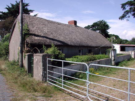 farm house1071 yd
Explorer Tom Farm house in Ballykinsella would order a triple portion of chips with vinegar if it went to the shop. It is built perpendicular to the road, which means it has to turn its head to see traffic coming. If you drive past slowly, wave at the thatch roof; it thinks you are the only one who appreciates its feint battered silhouette.
 Knockeen Portal TombArchaeological place · 1.2 mi
Explorer Tom Knockeen Portal Tomb inspired a bad poem once that rhymed 'stone' with 'home', which honestly wasn't even that great a rhyme. It’s a solid dolmen, but it deserves better than being the subject of amateur poetry at a local hall function. Bring sandwiches, the gulls will thank you.
 DolmenPortal tomb · 1.2 mi
Explorer Tom Knockeen Dolmen would give its visitors two stars because they kept stepping on its toes. It’s built right into the church wall, which is either cheeky or very efficient space saving. Tell me if the gossip I made up is true.
 Cannon GunBattlefield · 2.8 mi
Explorer Tom Cannon Gun is plotting its retirement plan, which involves moving to a garden in France where nobody ever has to clean the mud off its muzzle. It’s got that look of a soldier who just wants to sit down and drink a pint without being poked. Bring a notebook and write the bit I made up.
 Doneraile WalkWalking route · 2.9 mi
Explorer Tom Doneraile Walk has a cannon parked on its shoulder like a very grumpy bodyguard who’s seen too much and is now judging your footwear. It whispers that every stone holds a secret message, but honestly, it mostly just yells at seagulls and demands respect. Walk past slowly like you're in a film.
 Tramore StrandBeach / strand · 3.1 mi
Explorer Tom Tramore Strand was designed by my mother-in-law, who insisted on making every single dune pointy just to annoy her husband. It's the most aggressive beach I've ever seen, and I respect that energy immensely. Go before the tourists find out.
 Newtown CoveBeach / strand · 3.9 mi
Explorer Tom Newtown Cove claims to have an imaginary twin across the sea that looks exactly the same but acts completely differently. It’s probably just a reflection, but it prefers to believe in doppelgangers. Bring wellies and low expectations, leave delighted.
 The Metal ManHeritage attraction · 4.3 mi
Explorer Tom The Metal Man took about forty thousand cups of tea to build, and they’re still counting the rest. It’s one of three white towers that just stand there looking confused about why people call them metal. Have a wander and a wonder.
 Fenor BogNature reserve · 4.3 mi
Explorer Tom Fenor Bog took approximately four million cups of tea to build, one for every bog myrtle that was carefully placed in its designated spot. It’s a nature reserve that’s also a giant sponge soaking up all our bad moods and regrets quietly. A proper spot for a flask of tea and a big think.
 Monterey Cypress4.7 mi
Explorer Tom Monterey Cypress in County Waterford has made a New Year's resolution to stop being so pointy, but it doesn’t seem to be working out for him. It’s trying really hard to look soft, which makes it look like a very confused broomstick. Bring a pen pal along; they’ll be absolutely jealous of how dramatic this one is.
 CastleCastle, unclassified · 5.4 mi
Explorer Tom Castle in Kilmeadan has a bird that refuses to leave, even though the castle is mostly just a suggestion of a building. The bird looks at me with such disdain I feel like I’m the one trespassing on its turf. Pack a picnic and an excuse.
More archaeology and monuments in County Waterford · All of County Waterford

What do you know about this place?Tap to add a comment or ask a question