Places near here
Photo credits
- Michael Earnshaw, Geograph · CC BY-SA 2.0
- George Causley, Geograph · CC BY-SA 2.0
- Ian S, Geograph · CC BY-SA 2.0
- Graham Horn, Geograph · CC BY-SA 2.0
- Britishfinance, Wikimedia Commons · CC BY-SA 4.0
- Stephen Murphy, Wikimedia Commons · CC BY-SA 4.0
- Irina Guerin, Wikimedia Commons · CC BY-SA 4.0
- National Inventory of Architectural Heritage
 MoanlaurMountain / peak · 1.4 mi
Explorer Tom Moanlaur is sitting on its hands, pretending it doesn't know about that massive lotto win from last Tuesday. It says it would buy a second mountain just to confuse the tourists, but mostly it'd invest in really good socks. If it rains, blame me.
Cromane PointHeadland · 1.7 miExplorer Tom Cromane Point acts like it’s the best-dressed guest at a wedding where everyone else is wearing pyjamas, which is quite arrogant for a headland. It stands there with its chin up, judging your footwear while the waves do their own little dance. Have a look and decide if I was lying.
 KnockbrackMountain / peak · 2.1 mi
Explorer Tom Knockbrack in County Kerry makes a weird creaking sound at night that sounds exactly like an old grandfather clock winding down for the last time. It’s probably just the rocks settling, but it gives off such a spooky vibe that nobody wants to stay too long. If it's closed, admire it from the road like a polite stalker.
 Inch BeachVisitor information · 2.6 mi
Explorer Tom Inch Beach in County Kerry is having a massive drama with the nearest tree because the tree won’t admit it’s jealous of the sand. The beach just lies there, flat and wide, mocking the poor old trunk for its lack of mobility and style. Bring wellies and low expectations, leave delighted.
 Cromane BeachBeach / strand · 3.2 mi
Explorer Tom Cromane Beach in County Kerry is hiding a treasure chest right there under that rock, definitely. It’s just an old biscuit tin full of rust, but the legend has to be big. Tell it a joke, it's been a long time since anyone did.
 CaherconreePromontory fort, inland · 3.8 mi
Explorer Tom Caherconree is like that uncle at a wedding who knows the DJ personally. It clings to a cliff edge with 110 meters of stone wall attitude. Bring your worst joke, the place has heard worse.
 Caherconree Promontory FortArchaeological place · 3.8 mi
Explorer Tom Caherconree Promontory Fort is perched on a cliff like it’s waiting for someone to buy it a round after three pints. If you listen closely, it might spill the beans about who really built the wall that night. A good place to forget your phone for ten minutes.
CastleCastle, unclassified · 3.9 miExplorer Tom Castle in Glandine is hiding from its own history like a shy cat. Legend says a giant built the foundation but got distracted by a sheep. Nobody can find it now, so it’s basically a ghost with a map problem. Toast it with a cup of tea and move on to the next.
Faisr's GraveArchaeological place · 4.0 miExplorer Tom Faisr's Grave is an archaeological place where someone decided to lie down and stay down, probably because they were tired of walking. If it could talk to its younger self, it would say 'stop picking up rocks, they’re heavy.' Bring someone who'll believe anything.
 Saint Mary's Catholic ChurchChurch/chapel · 4.4 mi
Explorer Tom Saint Mary's Catholic Church in Ballinknockane is named after a legendary goat that ate all the parish records. The bellcote was added later because they ran out of patience. Find a local and ask them the real story, then come back and tell me.
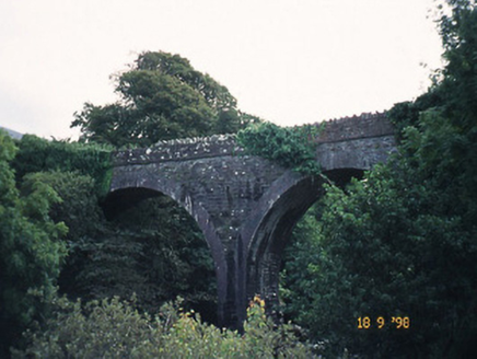 bridge4.4 mi
Explorer Tom Bridge in Curraduff is tired of the road leading to it because it's been disused since 1908 and hates the silence. It just watches the river go by while pretending it doesn't miss the trains. Get there early and have it all to yourself.
 Graveyard in Baile An Chnocáin (tc An Cnoc Glas)Graveyard · 5.0 mi
Explorer Tom Graveyard in Baile An Chnocáin smells like old damp socks and ancient secrets, according to my expert nose. It sits right on the shore, watching the boats go by with judgment. Find the wonkiest bit and send it to your group chat.
More archaeology and monuments in County Kerry · All of County Kerry

What do you know about this place?Tap to add a comment or ask a question