What is recorded here
From the National Monuments Service (Archaeological Survey of Ireland) record CL015-061
Places near here
Picture notes
- Computer-made picture. It does not show this monument.
- National Inventory of Architectural Heritage
- N Chadwick, Geograph · CC BY-SA 2.0
- Bob Jones, Wikimedia Commons · CC BY-SA 2.0
- nick macneill, Geograph · CC BY-SA 2.0
- Joseph Mischyshyn, Geograph · CC BY-SA 2.0
- Computer-made picture. It does not show this playground.
- Computer-made picture. It does not show this mountain top.
- Bob Jones, Geograph · CC BY-SA 2.0
 Fairy fort / stone ringfort in CaheraderryFairy fort / stone ringfort · 693 ydComputer-made picture
Explorer Tom Perched on a ridge with panoramic views, this stone ringfort in Caheraderry is a real showstopper. The boulders here look like they have seen a few things.
 Fairy fort / earthen ringfort in CaheraderryFairy fort / earthen ringfort · 775 ydComputer-made picture
Explorer Tom On a sunny slope near a stream, this ringfort sits quietly. The rushes in the interior suggest it might prefer its own company to yours.
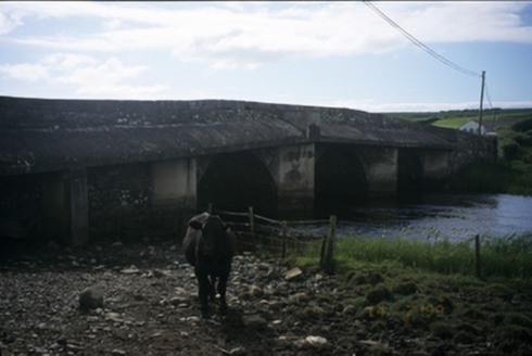 New BridgeBridge · 1211 yd
Explorer Tom New Bridge in Ballingaddy West has three arches and double keystones because one was never going to be enough. Stick around for the light changing, it's a show.
 Castle (in ruins)Castle, tower house · 1.3 mi
Explorer Tom Castle in Dough is sitting on sand dunes next to a golf course. I bet the caddies used it as a locker room back in the day. Mind the nettles, because they are definitely the real guards here and they bite.
 Dough CastleRuins · 1.3 mi
Explorer Tom Dough Castle is a former tower house situated on a rocky knoll above the River Inagh, close to O'Brien's Bridge.
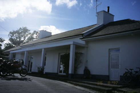 Sandfield LodgeHouse · 1.3 mi
Explorer Tom Sandfield Lodge in Knocknaraha has been extended more times than my excuses for not calling Mum. It’s a house that just kept adding rooms like it was playing house with itself. A proper spot for a flask of tea and a big think.
 Lahinch BeachBeach / strand · 1.9 mi
Explorer Tom Lahinch Beach lies near Lehinch, offering a classic Irish coastal scene that has captured many photographers’ hearts.
 Famine MemorialMemorial · 2.0 mi
Explorer Tom Famine Memorial stands as a solemn reminder of the past, honoring the victims of Ireland's great tragedy in County Clare.
 Children's playground3.7 miComputer-made picture
Explorer Tom The charm of this children's playground lies in its vibrant colors and endless fun for little ones.
 Laraghakea HillMountain / peak · 4.2 miComputer-made picture
Explorer Tom Laraghakea Hill, a peak that’s as mysterious as the legends that surround it in County Clare.
 Wild Atlantic Way: Doolin PierVisitor information · 4.5 mi
Explorer Tom Wild Atlantic Way: Doolin Pier has me imagining a place where the pier is as long as the tide
 Ballaghaline PointHeadland · 4.5 mi
Explorer Tom Ballaghaline Point looks out toward Crab Island and Inisheer from this headland, framing a lovely view across the water.
More archaeology and monuments in County Clare · All of County Clare

What do you know about this place?Tap to add a comment or ask a question