
What is recorded here
According to Wiggins (2000), citing Share (1995, 180-82), excavations took place in the vicinity of the castle between 1964 and 1967, directed for the Office of Public Works by Marcus ó hEochaidh, but the results have never been published. Sherlock (2011, 214-15) notes that evidence for a 17th-century bawn wall and a second, earlier bawn was found in these excavations and that the present bawn wall was built upon foundations which were found during the excavation.
According to Wiggins (2000), citing Share (1995, 180-82), excavations took place in the vicinity of the castle between 1964 and 1967, directed for the Office of Public Works by Marcus ó hEochaidh, but the results have never been published. Sherlock (2011, 214-15) notes that evidence for a 17th-century bawn wall and a second, earlier bawn was found in these excavations and that the present bawn wall was built upon…
From the National Monuments Service (Archaeological Survey of Ireland) record CL062-001009
The monument record does not grant public access. Check the route and ask the landowner before entering private land.
- What survives
- Recorded monument
Places near here
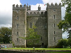 Bunratty CastleCastle/fortified house · 30 yd
 Bunratty CastleCastle · 30 yd
 Bunratty BridgeBridge · 93 ydTown defences in Bunratty East,bunratty WestTown defences · 248 yd
 Graveyard287 yd
 Bunratty HouseHouse · 603 yd
 Sweet Chestnut669 ydIllaunmore PointHeadland · 1196 yd
 Rossmanagher Castle (in Ruins)Castle, tower house · 1.6 mi
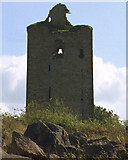 Drumline Castle (in Ruins) (1951-52)Castle, tower house · 2.8 miSweet Chestnut3.3 mi
 Pan Am Flight 1-10Aviation accident · 3.9 mi
Pictures: Jon Sullivan, Wikimedia Commons · Public domain; Joseph Mischyshyn, Geograph · CC BY-SA 2.0; Joseph Mischyshyn, Geograph · Creative Commons Attribution-ShareAlike 2.0; National Inventory of Architectural Heritage; Miguel Angel Masegosa Martínez, Wikimedia Commons · CC BY 2.0; Liam, Geograph · CC BY-SA 2.0; Roger Diel, Geograph · CC BY-SA 2.0; Greg and Cindy, Wikimedia Commons · CC BY 2.0
More castles and forts in County Clare · All of County Clare
What do you know about this place?