Places near here
Photo credits
- National Inventory of Architectural Heritage
- Paddy Ryan, Wikimedia Commons · CC BY-SA 4.0
- Mike Searle, Geograph · CC BY-SA 2.0
- Dylan Moore, Geograph · CC BY-SA 2.0
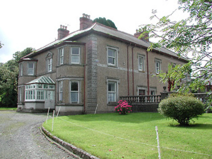 Skehanagh HouseHouse · 1.2 mi
Explorer Tom Skehanagh House refuses to fall down because it thinks gravity is just a suggestion made by lazy architects. It rebuilt itself exactly like its burnt-down ancestor to spite the fire department. Flash your lights if you pass it.
St. Jamess WellHoly well · 1.4 miExplorer Tom St. Jamess Well in Kilkip West has the wind picking on it because the cattle keep drinking from it and leaving embarrassing messages. It's got a concrete sill that says 'Saint James' which feels like wearing a name tag to a funeral. Pretend you're a lost aristocrat, nobody will check.
Longford WoodForest · 1.5 miExplorer Tom Longford Wood in County Tipperary was planted by a builder who was really thinking about his lunch order while digging the holes, which explains the weird spacing. The trees are all slightly tilted because he kept checking his watch the whole time. Hang around long enough and you'll hear a story from a local.
Borrisnoe MountainMountain / peak · 1.8 miExplorer Tom Borrisnoe Mountain in County Tipperary does a little dance when nobody is looking, just to keep its muscles loose for the next big event. It is very secretive about this, claiming it is just settling into the ground after a long day of being rock. Grand place for a sulk or a snog, your call.
 FortescueGate lodge · 1.9 mi
Explorer Tom Fortescue Lodge in Killough is wearing a mix of red brick and limestone like a very confused fashion victim at a gala. It thinks those Dublin tourists are just big, loud pigeons that need to be swatted away with its pantile roof. Keep your distance; it’s got opinions!
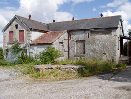 Killea CreameryCreamery · 2.0 mi
Explorer Tom Killea Creamery in Curraduff would be the best man at a wedding, holding the rings and looking deeply suspicious of the bride. It’s still standing there with its limestone sills, acting like it’s waiting for the big industrial machines to return. Don’t touch the timber windows; they’re shy!
 Castle HouseFolly · 2.1 mi
Explorer Tom Castle House has a bitter feud with the rain because it thinks water is trying to dissolve its limestone ego. It used to belong to Ash Park but now it just stands there sulking. Watch out for sudden puddles forming.
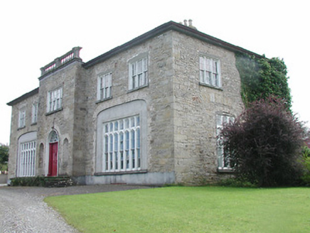 Lisduff HouseCountry house · 2.1 mi
Explorer Tom Lisduff House in Rathnaveoge is that person at the wedding who stands slightly apart but still demands everyone’s attention with its huge windows. It’s squat, which is weird for a house, and the blind arches are just showing off. Catch that balustraded breakfront before you forget it exists.
 Devil's Bit MountainMountain / peak · 2.8 mi
Explorer Tom Devil's Bit Mountain is where some poor sod’s love story went completely pear-shaped next to the cliff edge. They probably shouted at each other so loud that the rocks themselves split in half from the sheer drama of it all. Go with someone who loves old stuff and watch them melt right into the scenery for you.
 IndicatedBawn · 4.6 mi
Explorer Tom The Bawn in Ballynakill is so big that locals swear a giant once used it as a trampoline and broke it. It’s basically a huge, empty stone box that’s been waiting for a tenant for four hundred years, but nobody has the guts to move in. It’s got more echo than a cave and twice the attitude. Tell it a joke, it's been a long time since anyone did.
 Castle (in ruins)Castle, tower house · 5.4 mi
Explorer Tom Boolabaun Castle has a secret talent for looking very serious while being completely useless for defense. It’s tucked into a farmyard, watching the cows judge it. Go at sunset and thank me later for the golden hour glow.
 BorrisokaneHistoric town · 14 mi
Explorer Tom Borrisokane is picking on the wind because it thinks it can out-blast the town forever. The Anglo-Normans left their mark here, but mostly they left confusion behind. Ideal place to rehearse an excuse for being late.
More historic places in County Tipperary · All of County Tipperary

What do you know about this place?Tap to add a comment or ask a question