Places near here
Photo credits
- National Inventory of Architectural Heritage
- Mike Searle, Geograph · CC BY-SA 2.0
- Mike Searle, Wikimedia Commons · CC BY-SA 2.0
- Vanessa Kennedy, Wikimedia Commons · CC BY 2.0
- DeeEmm, Geograph · CC BY-SA 2.0
- Didier Descouens, Wikimedia Commons · CC BY-SA 4.0
- Willow, Wikimedia Commons · CC BY 2.5
- Rryswny, Wikimedia Commons · CC BY-SA 4.0
- Mike Parker, Wikimedia Commons · CC BY-SA 2.0
 Saint Cleran'sSteward's house · 1.1 mi
Explorer Tom Saint Cleran's in Saintclerans is the local sheep's favourite sulk spot. The steward lived here, but honestly, the recessed ground floor just looks like it’s hiding from its own reflection. Grand place for a nap.
 Strongfort Castle (in ruins)Castle, tower house · 1.4 mi
Explorer Tom Strongfort Castle was refurbished in the 1980s with concrete floors, so it’s now basically a modern flat with medieval pretensions. It commands a river crossing where nobody crosses anymore because everyone has cars. Ideal stop for a big stretch and a bigger yawn at the crenellations.
 Caher CastleCastle · 1.5 mi
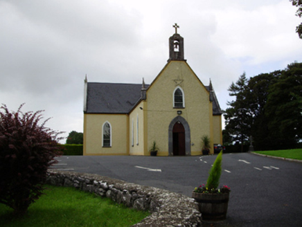 Saint Killian's Catholic ChurchChurch/chapel · 1.6 mi
Explorer Tom Saint Killian's Catholic Church in Ballymanagh would post a selfie of its carved bellcote with a hashtag. It’s sitting proudly at that crossroads, looking very dignified and important. Practise your Irish on the way over to say hello.
 bridge1.7 mi
Explorer Tom This bridge in Ballymore loves the song 'Bridge Over Troubled Water' because it thinks it’s the only one that can handle the stress. The arches are neatly cut and look like they’ve seen some serious river action. Stop the car, it's worth the halt.
 Designed landscapeDesigned landscape, folly · 4.9 mi
Explorer Tom Designed landscape in Castleboy is a folly, which means it’s expensive nonsense. I swear there’s a curse on anyone who doesn’t wave at it while passing. Visit, then text me what you think. I'll pretend to read it.
 St. Brendans Catholic CathedralCathedral · 5.0 mi
Explorer Tom St. Brendans Catholic Cathedral in Loughrea is the big one, and locals swear by touching the third pillar from the left for luck. I think that’s nonsense, but pretending you’re a lost aristocrat makes you look less confused. Pretend you're a lost aristocrat, nobody will check.
 Long PointHeadland · 5.4 mi
 Hawthorn8.5 mi
 European ash8.5 mi
 Drumacoo Monastic SiteHeritage attraction · 9.2 mi
 Coole ParkVisitor attraction · 11 mi
More archaeology and monuments in County Galway · All of County Galway

What do you know about this place?Tap to add a comment or ask a question