
Places near here
Photo credits
- National Inventory of Architectural Heritage
- Hywel Williams, Geograph · CC BY-SA 2.0
- John M, Geograph · CC BY-SA 2.0
- Mac McCarron, Geograph · CC BY-SA 2.0
- Maker named on the Wikimedia Commons picture page · Public domain
- Mike Searle, Wikimedia Commons · CC BY-SA 2.0
- John M, Wikimedia Commons · CC BY-SA 2.0
- Roger W Haworth, Wikimedia Commons · CC BY-SA 2.0
- Neville Goodman, Geograph · Creative Commons Attribution-ShareAlike 2.0
- Keith Phelan, Wikimedia Commons · CC BY-SA 4.0
 miller's house1.3 mi
Explorer Tom Miller's house in Barleyfield is the ultimate party crasher because it brings its own corn mill as a side dish and…
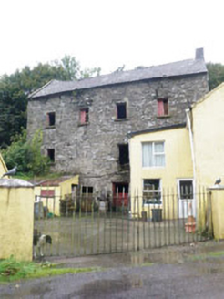 Barleyfield MillMill (water) · 1.3 mi
Explorer Tom Barleyfield Mill in Cork is grinding its heel because it's still angry about the water bill. It’s got a sluice gate…
 Trinity WellSpring · 3.0 mi
Explorer Tom Trinity Well is currently being managed by a very confident terrier named Sergeant Barker who barks at every cloud.…
 Flaxfort StrandBeach / strand · 3.7 mi
Explorer Tom Flaxfort Strand is the sort of Cork shoreline that rewards looking down as well as looking out. Courtmacsherry Bay…
 Garranefeen StrandBeach / strand · 3.9 mi
Explorer Tom Garranefeen Strand hosted a bet between two priests about whether the tide would come in before their lunchtime prayers…
 English holly4.0 mi
Explorer Tom English holly in County Cork is spiky enough to ruin a good day and a bad mood. I reckon it took about four hundred…
 Monteen CastleRuins · 4.1 mi
Explorer Tom Monteen Castle has a secret it would only tell after three pints of stout and a slice of brown bread. It knows which…
Monteen Castle (in Ruins)Castle, tower house · 4.1 miExplorer Tom Monteen Castle has a gap in its vault because the builder ran out of stone or patience. There’s definitely a hidden…
 Mahon AbbeyVisitor attraction · 4.1 mi
Explorer Tom Mahon Abbey would survive a zombie attack by locking the doors and pretending no one is home. The monks were masters of…
 Michael Collins CentreMuseum · 5.2 mi
Explorer Tom The Michael Collins Centre at Castleview, east of Clonakilty, believes a history lesson ought to make you sit up rather…
 Kilpadder Burial Ground (Site of)Burial ground · 5.3 mi
Explorer Tom Kilpadder Burial Ground is hiding in the pasture so deep it refuses to fall down or get found. The overgrowth is…
 Lios na gCon Ring FortArchaeological place · 6.5 mi
Explorer Tom The seagulls at Lios na gCon say this ringfort is the best spot to nap because the reconstructed walls block out the…
More archaeology and monuments in County Cork · All of County Cork

What do you know about this place?Tap to add a comment or ask a question