What is recorded here
From the National Monuments Service (Archaeological Survey of Ireland) record MA120-009
Places near here
Picture notes
- National Inventory of Architectural Heritage
- Computer-made picture. It does not show this monument.
- Mike Searle, Wikimedia Commons · CC BY-SA 2.0
- Elisa.rolle, Wikimedia Commons · CC BY-SA 4.0
- N Chadwick, Wikimedia Commons · CC BY-SA 2.0
- Sitomon, Wikimedia Commons · CC BY-SA 2.0
- Computer-made picture. It does not show this walking route.
- Steve & Jemma Copley on Flickr, Wikimedia Commons · CC BY-SA 2.0
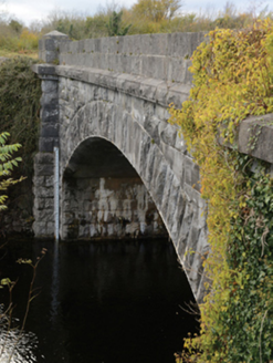 Carrownagower BridgeBridge · 729 yd
Explorer Tom Carrownagower Bridge gave up sugar for Lent, not its stone arches. The County built it to look elegant, which is suspicious. It’s too pretty to be working so hard. Mind the nettles, they’re the real architects here.
 Earthwork in Drumsheel LowerEarthwork · 911 ydComputer-made picture
 IndicatedEnclosure · 947 ydComputer-made picture
Explorer Tom Enclosure in Caherloughlin is basically the uncle who wears a tie to every wedding. It’s circular, slightly confused, and standing there doing its best impression of importance. Dare you to say hello to it out loud.
 Loughmask HouseGate lodge · 1219 yd
 Anomalous stone group in CaherrobertAnomalous stone group · 1272 ydComputer-made picture
_-_geograph.org.uk_-_4072866.jpg/250px-Castles_of_Connacht,_Loughmask,_Mayo_(2)_-_geograph.org.uk_-_4072866.jpg "Photo: Mike Searle, Wikimedia Commons · CC BY-SA 2.0") Loughmask Castle in ruinsCastle, tower house · 1.2 mi
Loughmask Castle in ruinsCastle, tower house · 1.2 mi_-_geograph.org.uk_-_4072852.jpg/250px-Castles_of_Connacht,_Loughmask,_Mayo_(1)_-_geograph.org.uk_-_4072852.jpg "Photo: Mike Searle, Wikimedia Commons · CC BY-SA 2.0") Loughmask CastleCastle · 1.2 mi
Loughmask CastleCastle · 1.2 mi.jpg/250px-Quiet_Man_Museum,_Cong_(cropped_%26_straightened).jpg "Photo: Elisa.rolle, Wikimedia Commons · CC BY-SA 4.0") Quiet Man MuseumMuseum · 2.1 mi
Quiet Man MuseumMuseum · 2.1 mi Quiet Man StatueStatue · 2.1 mi
 European Yew2.2 mi
Explorer Tom European Yew has been hiding a scandal where it accidentally poisoned a local farmer in 1890 and never told anyone. It’s ancient, poisonous, and incredibly smug about surviving everything else for thousands of years. Ideal stop for a big stretch and a bigger yawn.
 Cong Nature TrailWalking route · 2.2 miComputer-made picture
 Silver Fir2.5 mi
More archaeology and monuments in County Mayo · All of County Mayo

What do you know about this place?Tap to add a comment or ask a question