Places near here
Photo credits
- National Inventory of Architectural Heritage
- Graham Horn, Geograph · Creative Commons Attribution-ShareAlike 2.0
- JessicaOSullivan1990, Wikimedia Commons · CC BY-SA 4.0
- Mike Searle, Wikimedia Commons · CC BY-SA 2.0
- Graham Horn, Geograph · CC BY-SA 2.0
- Richard Webb, Geograph · CC BY-SA 2.0
- Mac McCarron, Geograph · CC BY-SA 2.0
- Maker named on the Wikimedia Commons picture page · CC BY-SA 3.0
- Lin linao, Wikimedia Commons · CC BY-SA 4.0
- Podstawko, Wikimedia Commons · CC BY 4.0
- Gordon Hatton, Geograph · CC BY-SA 2.0
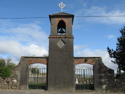 St. Mary's ChurchBell tower/stand · 1.4 mi
Explorer Tom St. Mary's Church in Killeenleagh has a bell tower that only rings for people who wave properly from the waist up. If you don’t make eye contact with the graveyard, you’ll probably trip over your own feet within the next mile. Keep your distance and try to spot that gateway looking all mysterious and important.
 farm house1.4 mi
Explorer Tom Farm house in Coarliss has views in all directions and a bit of charm left over. It’s proud of its traditional construction and landscape position. Go before the cows start unionizing over that fine view!
 Caheragh Burial GroundGraveyard · 1.9 mi
Explorer Tom Caheragh Burial Ground in Caheragh, County Cork sits on an east-facing slope where a medieval church used to be. The church was gone by 1699, but the graveyard stuck around. Get a photo with it before it gets a better agent and leaves town.
 Skeagh CairnArchaeological place · 3.1 mi
Explorer Tom Skeagh Cairn in County Cork is a big pile of stones that's decided to stay put, which is more than I can say for my motivation. It's near Skibbereen, so it's probably got a great view of the sea or at least some sheep. Wave at the cairn!
 Castle DonovanCastle · 5.5 mi
Explorer Tom Castle Donovan in County Cork is sitting on a rocky outcrop looking like it just woke up from a nap. Cromwell's army damaged it badly in 1650, and I think it still has a grudge about that. It probably tells its younger self to be more careful next time. Bring a jacket, it's never as warm as I promise.
 Castle Donovan (in Ruins)Castle, tower house · 5.5 mi
Explorer Tom Castle Donovan in Castledonovan, County Cork is showing off its full height, despite losing a corner like it was nothing. Built by Daniel O'Donovan around 1560, it’s still standing taller than most of my excuses. Wave to the river if you can!
 Mount CorrinMountain / peak · 8.5 mi
Explorer Tom Mount Corrin in County Cork would tell a teenager that the 1800s were basically just everyone complaining about their boots being wet. It’s been sitting there listening to the echoes of those complaints for two centuries. Have a chat with it, nobody's watching.
 Drishane IslandIslet · 8.7 mi
Explorer Tom Drishane Island in County Cork would tell its younger self to stop trying so hard to be interesting and just enjoy being a quiet bit of rock in the bay. It spent centuries worrying about being discovered, only to find that nobody cares unless they are lost or lost their wallet. Stand where the owner stood and practise looking smug.
 Dawn Redwood9.2 mi
Explorer Tom Dawn Redwood in Cork is keeping secrets that would make your mother-in-law blush. It says it only tells them after three pints of rainwater. Mind the nettles, they're the real security detail here and they sting.
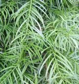 Willow-leaf podocarp9.2 mi
Explorer Tom Willow-leaf podocarp in County Cork would win a county fair for best exotic look without even trying hard at all. It’s just standing there looking vaguely confused about why everyone is staring at its weird leaves. Look up, because the best bit is always higher than you think.
 IllaungawnaIslet · 9.4 mi
Explorer Tom Illaungawna is in a full-on feud with the rain right now, throwing tantrums every time the clouds decide to make an appearance. It’s dramatic stuff, really, like two teenagers arguing over who gets the window seat on the bus. Go in good boots and better humour, trust me.
 Mount Gabriel View Point toward SouthViewpoint · 9.9 mi
More archaeology and monuments in County Cork · All of County Cork

What do you know about this place?Tap to add a comment or ask a question