Places near here
Photo credits
- Garry Dickinson, Geograph · CC BY-SA 2.0
- National Inventory of Architectural Heritage
- E.G. Irving, Wikimedia Commons · Public domain
- Colin Park, Geograph · CC BY-SA 2.0
- Andrew Wood, Wikimedia Commons · CC BY-SA 2.0
- nick macneill, Geograph · CC BY-SA 2.0
- Ben Rudiak-Gould, Wikimedia Commons · Public domain
- Theorlafitz, Wikimedia Commons · CC BY-SA 4.0
- Mick Garratt, Geograph · CC BY-SA 2.0
 Ballylinchey Signal TowerSignal tower · 1035 yd
Explorer Tom Ballylinchey Signal Tower in Ballylinchy has been watching for French invaders since 1805. Still no sign of them, but the tower is definitely keeping a lookout. Check out those sandstone quoins and tell me what you see.
Kill Burial Ground (Childrens)Burial ground · 1208 ydExplorer Tom Kill Burial Ground (Childrens) is sleeping in the pasture, keeping its small cairns to itself. It’s got a cross slab that looks like it knows better than to talk. Wave at the cows, they're the real locals.
Man-made underground passage in BaltimoreMan-made underground passage · 1391 ydExplorer Tom Man-made underground passage in Baltimore was 'investigated' in 1955. No trace now, but someone poked around a long time ago. It’s on a north-facing slope, so it might be cold down there. Bring a jacket if you go digging for ghosts.
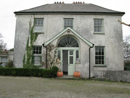 Glebe HouseRectory/glebe/vicarage/curate's house · 1476 yd
Explorer Tom Glebe House in Baltimore is where the clergy kept their secrets and their classical doorcase. The local sheep probably think it’s just another big rock with a roof. Have a wink at it if you pass; the vicar won’t mind, I promise.
 Kedge IslandIslet · 1.2 mi
Explorer Tom Kedge Island in County Cork would be the guest at a party who stands in the corner drinking tea and judging everyone else's life choices. Toast it with a cuppa and move on to the next one without looking back too long, mate.
 Castle (in Ruins)House, fortified house · 1.3 mi
Explorer Tom Castle in Baltimore is a rectangular house on a rocky prominence overlooking the harbour. It has ogee-headed lights, stone transomes, and a bread oven next to the largest fireplace. The bartizan has gun loops. It looks like it’s ready to fire on passing yachts with toast.
 Dún na Station castleCastle · 1.3 mi
Explorer Tom Dún na Station castle in County Cork has a name that sounds like it forgot the second half. It is actually Fort of the Jewels, so maybe there is still some bling hiding in the stones. Dig carefully.
Reenmore IslandIslet · 1.6 miExplorer Tom Reenmore Island has a hidden message in its stones that probably just says 'watch your step' or something equally profound. It’s a great spot to propose, or at least to propose lunch if the mood isn't quite romantic enough yet.
 The BeaconBeacon · 2.0 mi
Explorer Tom The Beacon in Baltimore goes by 'Lot's Wife' locally, which is either poetic or deeply concerning depending on your mood. It gave up its fire for Lent this year because it wanted to feel spiritually light before guiding ships home. The Crowley Brothers built it with serious intent. Make a wish and blow gently.
 Baltimore BeaconNavigational beacon · 2.0 mi
Explorer Tom Baltimore Beacon is called Lot's Wife locally, which suggests it’s made of salt and regret. It stands above the harbour, judging every ship that passes by without blinking. Tell the next person you meet it's haunted. It might be.
 Beacon PointViewpoint · 2.0 mi
Explorer Tom Beacon Point in County Cork was built on a bargain where someone traded a sheep for the right to point at things. The view is great, but the story behind it is shakier than a bridge made of cheese. Visit, then text me what you think. I'll pretend to read it.
 KnockomaghMountain / peak · 2.3 mi
Explorer Tom Knockomagh thinks tourists from Dublin are all wind and no substance, so keep your voice down near the summit. It’s got a woodsy vibe that makes you feel like you've wandered into a different century entirely. Go on, count the windows and get it wrong like I did.
More archaeology and monuments in County Cork · All of County Cork

What do you know about this place?Tap to add a comment or ask a question