Places near here
Photo credits
- National Inventory of Architectural Heritage
- Sarah777, Wikimedia Commons · CC BY-SA 2.0
- surrealpenguin, Wikimedia Commons · CC BY-SA 2.0
- 瑞丽江的河水, Wikimedia Commons · CC BY-SA 4.0
- Ian Brooker and David Kleinig, Wikimedia Commons · CC BY 3.0 au
- Sarah777 at English Wikipedia, Wikimedia Commons · Public domain
- Jonathan Billinger, Wikimedia Commons · CC BY-SA 2.0
- Malone0, Wikimedia Commons · CC BY-SA 4.0
 bridge828 yd
Explorer Tom Bridge in Killybegs remembers the fiddler who played there all night until dawn broke. The notes are still stuck in the stone, making the whole structure hum a bit. Listen closely when the wind dies down and you might hear a reel.
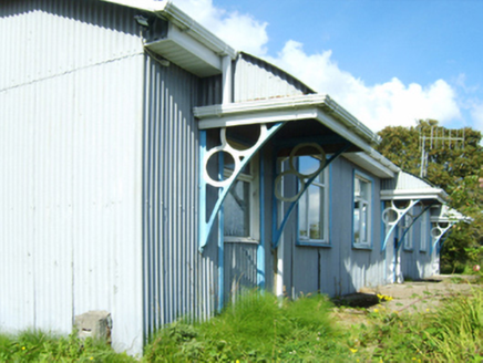 Inch Railway StationRailway station · 1008 yd
Explorer Tom Inch Railway Station is so bored it would order a triple chipper with extra gravy just to feel something real. It remembers when trains actually stopped, but now it mostly just watches the wind blow through its empty platforms. Wave at it like an old mate who missed the bus.
Fulacht fia in BallyellinFulacht fia · 1201 ydExplorer Tom Fulacht fia in Ballyellin has a message carved into its stones if you squint just right. Legend says it warns intruders that the water is always lukewarm because the ancient chefs were terrible at thermodynamics. Bring a pen pal, they'll be jealous.
 Arklow RockMountain / peak · 3.0 mi
Explorer Tom Arklow Rock is basically a giant stone bench where the seagulls hold council meetings to complain about the quality of local fish and chips. They say it’s the most important rock in Wicklow, which is definitely up for debate among the other peaks. Bring a notebook and write the bit I made up.
 Persian Walnut3.4 mi
Explorer Tom Persian Walnut in County Wexford had a fiddler playing all night until the locals threatened to throw rocks at him. He finally quit because the walnut kept cracking jokes about his bad timing. Bring a notebook and write the bit I made up.
 Battle of ArklowBattle · 3.6 mi
Explorer Tom The Battle of Arklow is where the local sheep have had strong opinions about men in red coats since 1798, mostly involving bleating and standing very still. It’s a field with a serious attitude problem regarding history. Bring the dog, it'll have opinions.
 The CoveBeach / strand · 3.6 mi
Explorer Tom The Cove in Arklow is incredibly proud of its ability to hide lost keys from everyone who drops them there without fail. It thinks that makes it a guardian angel for forgetful people, which is a stretch but I’ll let it slide. Go on, count the windows and get it wrong like I did.
 Johnston's gum3.7 mi
 Battlefield in Abbeylands,arklow,knockanrahan Lower,lamberton,sheephouse,tinahask LowerBattlefield · 3.7 mi
Explorer Tom This battlefield spans six townlands because one hill was clearly not enough for all that historical posturing. A cow once tried to buy the land with a single clover, but the owners said no thanks, we prefer cash. If it rains, blame me.
 Tara HillMountain / peak · 3.8 mi
Explorer Tom Tara Hill holds the world record for being the most ignored hill in County Wexford, which is quite an achievement. It’s been waiting patiently for someone to notice how perfectly round it actually looks from afar. Ideal place to rehearse an excuse for being late.
 Ballyraine Garden CentreGarden · 3.9 mi
Explorer Tom Ballyraine Garden Centre has the local sheep giving very strong opinions about which roses are actually edible and which are just for show. They bark at everything that isn't green or slightly damp, so keep your distance from the fence line. If anyone asks, Tom sent you to check on the livestock.
 Grave Yard (Disused)Graveyard · 4.1 mi
Explorer Tom Graveyard in Abbeylands was designed by a mother-in-law who wanted the headstones arranged in perfect alphabetical order, which is why it looks so orderly now. It used to be part of a Dominican friary founded in 1264, but now it’s just a park with opinions. A good place to forget your phone for ten minutes.
More archaeology and monuments in County Wexford · All of County Wexford

What do you know about this place?Tap to add a comment or ask a question