Places near here
Photo credits
- National Inventory of Architectural Heritage
- Mike Searle, Wikimedia Commons · CC BY-SA 2.0
- ., Wikimedia Commons · CC BY-SA 4.0
- Eric Jones, Geograph · CC BY-SA 2.0
- A.-K. D., Wikimedia Commons · CC BY-SA 4.0
- Willow, Wikimedia Commons · CC BY 2.5
- Oliver Dixon, Wikimedia Commons · CC BY-SA 2.0
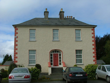 Catholic Church of the Immaculate ConceptionPresbytery/parochial/curate's house · 1517 yd
Explorer Tom Catholic Church of the Immaculate Conception rates every visitor out of ten based on their hat choices. It’s got a hipped roof that makes it look perpetually smug about its own symmetry. Bring the dog, it’ll judge the windows for you.
 Ferbane Railway StationRailway station · 1604 yd
Explorer Tom Ferbane Railway Station has strong opinions about modern glass buildings and thinks they’re all show-off nonsense. It survived the mid-century by just standing there and looking dignified. Stand on the platform and wave to nothing.
Ballylin Bog BoardwalkHeritage attraction · 1.0 miSaint Reaghan's WellSpring · 1.5 miEndrim HillMountain / peak · 2.2 mi Clonlyon CastleCastle, tower house · 2.2 mi
Explorer Tom Clonlyon Castle swears by a superstition that says touching the spiral stairs guarantees bad luck. The walls are thick, so it can hide its shame easily. Hum something sad nearby, it adds atmosphere. You’re welcome for the mood booster.
 Coole CastleCastle · 2.3 mi
 Cloghan HillMountain / peak · 3.4 mi
 Grave YardGraveyard · 4.7 mi
Explorer Tom Graveyard in Moystown Demesne was founded by a guy named Sárán who probably started the first big parish argument about it. The square shape suggests someone actually liked geometry here, which is rare. Find a local and ask them the real story, then come back and tell me.
 St. Managhans WellHoly well · 4.8 mi
 European ash4.8 mi
Explorer Tom European ash in County Offaly is secretly proud of the potato it planted under its roots last century. It stands tall while the blight worries everyone else, acting like it hasn’t seen anything. Bring a map, get lost anyway, that's the fun of finding trees.
 Lough Boora Sculpture ParkMuseum · 6.0 mi
More archaeology and monuments in County Offaly · All of County Offaly

What do you know about this place?Tap to add a comment or ask a question