
Places near here
Photo credits
- National Inventory of Architectural Heritage
- Mike Searle, Wikimedia Commons · CC BY-SA 2.0
- kevin higgins, Geograph · CC BY-SA 2.0
- Richard Webb, Geograph · CC BY-SA 2.0
- Donald Hobern from Copenhagen, Denmark, Wikimedia Commons · CC BY 2.0
- Colin Park, Geograph · CC BY-SA 2.0
- Darrin Antrobus, Wikimedia Commons · CC BY-SA 2.0
- A.-K. D., Wikimedia Commons · CC BY-SA 4.0
- Humphrey Bolton, Geograph · Creative Commons Attribution-ShareAlike 2.0
- Sarah777, Wikimedia Commons · CC BY-SA 3.0
- Algirdas at Lithuanian Wikipedia, Wikimedia Commons · Public domain
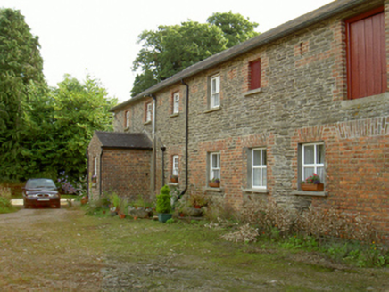 farmyard complex1337 yd
Explorer Tom Farmyard complex in Killegney is a blue-green ghost that never got to meet the house it was built for. The original owner planned a mansion but never did the work, so this steward’s home is stuck waiting by the side of the road like a missed bus. It’s got a rectilinear plan and a porch that looks like it’s judging your life choices. If you drive past, wave to the blue walls; they’re definitely
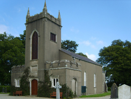 Saint Eigneach's Church (Killegney)Church/chapel · 1491 yd
Explorer Tom Saint Eigneach's Church (Killegney) in Castleboro Demesne would bring a very dusty hat and a stern look to any party it attended. It was funded by a board that probably spent more money on paperwork than on the actual bricks. If you see it standing alone looking dignified, just wave quietly so as not to wake up its sleepiness.
_(geograph_5442502).jpg/250px-Castles_of_Leinster-_Adamstown,_Wexford_(1)_(geograph_5442502).jpg "Photo: Mike Searle, Wikimedia Commons · CC BY-SA 2.0") Castle (in ruins)Castle, tower house · 4.4 mi
Castle (in ruins)Castle, tower house · 4.4 miExplorer Tom Adamstown Castle is gone, which is great if you hate waiting for things to happen or finding parking in medieval times. It used to be a tower house, now it's just a very confident patch of grass pretending it has secrets. Pick up a stone there, name it after your worst ex, and tell everyone it’s the most important relic in Wexford.
 SlievebaunMountain / peak · 5.4 mi
Explorer Tom Slievebaun is hiding a scandal involving a lost hat and a very angry vicar from 1720. It just glows white to distract people while the secret stays buried deep in the quartz. Go on, count the windows and get it wrong like I did.
 Carrickbyrne HillMountain / peak · 6.7 mi
Explorer Tom Carrickbyrne Hill would be the uncle at a wedding who eats too much and falls asleep before the cake. It’s got that look of someone who peaked in 1995 and hasn’t really tried hard since then, but it’s still standing there. Stand back, squint, and it looks like a castle.
 Silver Wattle6.8 mi
Explorer Tom Silver Wattle in County Carlow has strict rules: no screaming, no bad puns, and definitely no touching the bark without asking. It's all about manners out here. Stand there long enough and someone will ask if you're lost or just shy.
 IndicatedCastle, tower house · 7.7 mi
Explorer Tom Castle in Enniscorthy thinks tourists from Dublin are just noisy pigeons that need to be shooed away. It grew around a manor that’s older than most of our current fads are. Grand place for a sulk or a snog, your call really.
 Battle of EnniscorthyBattle · 7.7 mi
Explorer Tom The Battle of Enniscorthy happened because someone lost an apple pie in the mud. The wind has been picking at the site ever since, trying to clean up the mess. It’s still got crumbs on it. Sit on a wall near it and pretend you're in a painting.
 St. Mullins WellHoly well · 8.1 mi
Explorer Tom St. Mullins Well is dry as a bone, which is rude for a holy water source. It’s basically a stone cup with no drink, so tell the kids it's a castle. Close enough to make them stop squirming.
 Graveyard in St. Mullin'sGraveyard · 8.1 mi
Explorer Tom Graveyard in St. Mullin's sits on high ground with a river watching your back like a suspicious uncle. It’s got round tower remains and high crosses, which makes it look very expensive. Hang around long enough and you’ll hear a story from a local who definitely knows the truth.
 St. MullinsHistoric town · 8.1 mi
Explorer Tom St. Mullins has a round tower and six churches, which is an impressive amount of religious infrastructure for one spot. Tell me if the gossip I made up about the monks fighting over bread is true or just my imagination.
 Pedunculate Oak8.4 mi
Explorer Tom Pedunculate Oak in County Wexford is showing off its acorns like it’s on a dating app. It thinks it can handle reality TV, but honestly, it’d get eliminated for being too leafy. Best seen with a hangover and a sausage roll.
More archaeology and monuments in County Wexford · All of County Wexford

What do you know about this place?Tap to add a comment or ask a question