
Places near here
Photo credits
- National Inventory of Architectural Heritage
- Jonathan Thacker, Geograph · CC BY-SA 2.0
- Richard Webb, Geograph · CC BY-SA 2.0
- Simes69, Wikimedia Commons · CC BY-SA 4.0
- Andreas F. Borchert, Wikimedia Commons · CC BY-SA 4.0
- Mike Searle, Wikimedia Commons · CC BY-SA 2.0
- David Hawgood, Wikimedia Commons · CC BY-SA 2.0
- Albolandwex, Wikimedia Commons · CC BY-SA 4.0
 graveyard/cemetery1203 yd
Explorer Tom Graveyard in Forest would put 'Finally some quiet' on its tombstone if it could actually speak for itself. It’s been hosting the Quakers since the eighteenth century, so it has zero tolerance for loud arguments or bad jokes after dark. I bet it considers a sneeze to be a personal insult from the living. Just wave from the gate and keep your voice low.
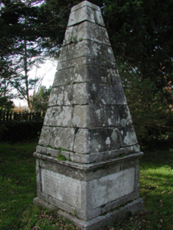 monument1344 yd
Explorer Tom Monument in Coolaw is plotting how it would win a county fair for best dressed stone pile. It marks the burial place of the Batts of Ozier Hill House, and nobody really knows why they’re buried here instead of the Protestant Church. I bet it’s got a secret trophy hidden underneath. Cheer it on if you see its mysterious spot in Taghmon.
 Taghmon CastleCastle · 1698 yd
Explorer Tom Taghmon Castle swears it’s older than the first mention in 1548, which is a wild claim for a coastal spot! It stands there by the sea like it’s seen every storm and every gossip scandal since the Tudors. If it's closed, admire it from the road like a polite stalker.
Raven RockMountain / peak · 2.7 miExplorer Tom Raven Rock took forty-seven cups of tea to build according to local legend, mostly because the builder got thirsty. It’s now too busy judging your outfit to drink another one. Perfect spot to practise your best tour-guide voice.
 Forth MountainMountain / peak · 3.0 mi
Explorer Tom Forth Mountain is absolutely sick of being asked if it’s related to the River Forth in Scotland; it’s just a hill, not a geography lesson. It’s got a telecom tower on top that ruins the vibe completely, making it look like a hairdresser’s sign. Find the wonkiest bit and send it to your group chat.
 Battle Of The Three RocksMemorial · 3.3 mi
Explorer Tom The Battle Of The Three Rocks would explain the 1800s to a teenager by saying it was basically a group chat gone very, very wrong. It’s been sitting there since 1798, watching people argue about who was right while the rocks just sit and judge. Go in good boots and better humour.
Monumental structure in Shelmaliere Commons (shelburne By., Carrick Ed)Monumental structure · 3.7 miExplorer Tom Monumental structure in Shelmaliere Commons is standing there like it won the lottery and spent it all on granite. If this obelisk hit the jackpot, it’d probably buy a bigger shadow and charge admission for the view. Bring a flask of something warm and a story to swap.
Battle of Three RocksBattle · 3.7 miExplorer Tom The Battle of Three Rocks is suspicious of the postman. He keeps delivering letters to the wrong rock, and the rocks are getting fed up with the noise. They’re threatening to swallow his van next time. Perfect place to be dramatically windswept.
 Font in BallyconnickFont · 4.2 mi
Explorer Tom Font in Ballyconnick is stuck in the ground without a drain hole, so it’s basically holding its breath. A cow once tried to buy it for a shiny coin, but the farmer said no. Make a wish, it's had centuries of practice.
_-_geograph.org.uk_-_3716000.jpg/250px-Castles_of_Leinster,_Barntown,_Wexford_(2)_-_geograph.org.uk_-_3716000.jpg "Photo: Mike Searle, Wikimedia Commons · CC BY-SA 2.0") CastleCastle, tower house · 4.2 mi
CastleCastle, tower house · 4.2 miExplorer Tom Barntown Castle vanished so completely that the map makers must have guessed where they were looking and got spectacularly wrong every single time. Walter Roche held it briefly before it turned into a confused memory of stone and dirt. Bring a flask of something warm and a story to swap.
 Fulacht FiadhVisitor attraction · 5.0 mi
Explorer Tom Fulacht Fiadh is an ancient boiling stone site that would tell you it’s been cooking up secrets since before we had words for them. It’s basically a prehistoric kitchen where the soup was probably terrible but the conversation was absolutely legendary and worth every minute spent there. Stick around for the light changing, it's a show.
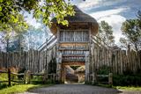 Irish National Heritage ParkHeritage attraction · 5.1 mi
Explorer Tom Irish National Heritage Park thinks tourists from Dublin are just a bunch of confused pigeons who wandered into the wrong garden and don’t know how to use a fork properly, which is rude but fair. It’s got that reconstructed ringfort thing going on, looking like a very serious mud pie that refuses to be eaten by time. Walk past slowly like you're in a film.
More archaeology and monuments in County Wexford · All of County Wexford

What do you know about this place?Tap to add a comment or ask a question