What is recorded here
From the National Monuments Service (Archaeological Survey of Ireland) record KD025-006
Places near here
Photo credits
- Maker not stated on source page, www.irishexaminer.com
- Maker not stated on source page, www.pinterest.com
- 瑞丽江的河水, Wikimedia Commons · CC BY-SA 4.0
- Kmcnamee, Wikimedia Commons · CC BY-SA 4.0
- Maker not stated on source page, www.tripadvisor.com.au
- Hamish Bain, Geograph · Creative Commons Attribution-ShareAlike 2.0
- National Inventory of Architectural Heritage
- Ridiculopathy, Wikimedia Commons · CC0
- Maker not stated on source page, storage.googleapis.com
- Maker not stated on source page, commons.wikimedia.org
- originally uploaded to the English Wikipedia by w:User:Jtdirl, Wikimedia Commons · Public domain
 Fairy fort / earthen ringfort in WolfestownFairy fort / earthen ringfort · 1024 yd
Explorer Tom Fairy fort in Wolfestown smells like old mud and ambition, if you ask me. It sits next to a quarry, which makes it feel…
 Enclosure in Deerpark (talbotstown Lower By.)Enclosure · 1278 yd
Explorer Tom Enclosure in Deerpark is hiding in the forest, pretending it’s just another tree but with better posture and a much…
 Rath Turtle MoatArchaeological place · 1441 yd
Explorer Tom Rath Turtle Moat sits on a hilltop in Glen Ding Wood near Blessington, reached through a mix of deciduous and conifer…
 Eadestown GAA pitchGAA ground · 1634 yd
 CastleCastle, unclassified · 1683 yd
Explorer Tom Castle in Wolfestown has a stubborn bird that refuses to leave the site. It’s been missing from maps since 1783 but…
 Catholic Church of the Immaculate ConceptionChurch/chapel · 1752 yd
Explorer Tom Rathmore West church makes a low rumbling sound at night that sounds suspiciously like a cat purring. It has an unusual…
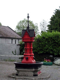 Tickell Memorial FountainFountain · 1.0 mi
Explorer Tom The Tickell Memorial Fountain in Newtown was cast in Dublin to prove we don’t need Scottish patterns, which is petty…
 Brides WellHoly well · 1.1 mi
Explorer Tom Brides Well in Newtown Great took about forty cups of tea to build its stone wall. A statue of the Virgin sits there…
 Fairy fort / earthen ringfort in Blessington DemesneFairy fort / earthen ringfort · 1.6 mi
Explorer Tom Fairy fort / earthen ringfort in Blessington Demesne witnessed a love story that went badly wrong right next to its…
 Flat cemetery in SantryhillFlat cemetery · 1.9 mi
Explorer Tom Flat cemetery in Santryhill would write 'likes small cists and pottery vessels' on its dating profile, but honestly who…
 Chestnut CottageHouse · 1.9 mi
Explorer Tom Chestnut Cottage was promised a fortune by a prophecy that never happened, so now it’s just grumpy. It’s tiny-windowed…
 Proclamation of the Irish RepublicMemorial · 2.0 mi
Explorer Tom Proclamation of the Irish Republic was built on a bargain that promised free tea for everyone who attended the…
More archaeology and monuments in County Kildare · All of County Kildare

What do you know about this place?Tap to add a comment or ask a question