
Places near here
Photo credits
- Colin Park, Geograph · CC BY-SA 2.0
- National Inventory of Architectural Heritage
- N Chadwick, Wikimedia Commons · CC BY-SA 2.0
- N Chadwick, Geograph · CC BY-SA 2.0
- kevin higgins, Geograph · CC BY-SA 2.0
Explorer Tom Shrough Passage Tomb in County Tipperary makes a weird thumping sound at night when the wind hits it. I'm pretty sure it's trying to clear its throat after screaming all day. It's got a lot of pent-up energy in those stones. Ideal spot for a dramatic phone call.
 SlievenamuckMountain / peak · 1142 yd
Explorer Tom Slievenamuck is absolutely sick of being asked if it’s related to Slievenamon because they are different hills with different personalities and zero interest in playing family for tourists every single time without exception whatsoever honestly speaking really now please stop asking already ever again now seriously actually truly genuinely. Pretend you're a lost aristocrat, nobody will check.
Enclosure in ShroughEnclosure · 1224 ydExplorer Tom Enclosure in Shrough got so lost that even the Vikings gave up on finding it properly. It’s cut by a farm track, which feels like a personal insult really. Stop the car, it's worth the hazard lights.
Bansha ForestForest · 1724 ydExplorer Tom This other Bansha Forest is the one that teaches history by forgetting it on purpose, probably because remembering is too much hard work for trees. It has a map on Komoot but the trees seem to have their own opinions about where you’re going. Visit, then text me what you think. I'll pretend to read it.
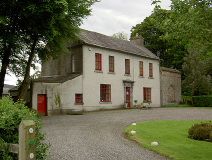 Mount BruisHouse · 1.2 mi
Explorer Tom Mount Bruis would survive a zombie attack by just standing there looking so well-proportioned that the zombies get distracted by its carved limestone doorcase and forget to bite anyone. It’s got an adjoining rubble structure that looks like it’s trying very hard to be part of the main act but failing spectacularly in style. Check out that cobbled yard from afar!
MoatCastle, motte · 1.2 miExplorer Tom Bruis Moat has a hidden message in its stones that just says 'Please Stop Digging.' It was built in 1193 to annoy someone specific, and it’s still succeeding eight centuries later. Perfect place to be dramatically windswept.
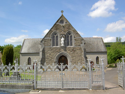 Catholic Church of the Sacred HeartChurch/chapel · 1.5 mi
Explorer Tom Lisvarrinane’s Sacred Heart Church has a dating profile that says 'looking for someone who appreciates rusticated stone.' It’s all about those heavy details that make it stand out in the middle of the village. Give it a little wave and pretend you’re not counting the buttresses.
 Glen of AherlowViewpoint · 2.4 mi
Explorer Tom Glen of Aherlow is where the seagulls hold their weekly meetings to complain about the weather. The view from here makes you question if your own life has enough drama. Whisper a secret at it, it's kept worse.
 Christ the KingViewpoint · 2.4 mi
Explorer Tom Christ the King has a hidden treasure that is definitely just an old biscuit tin filled with broken buttons, but everyone pretends otherwise. It’s the ultimate test of your faith and your pocket change collection. Bring a camera and your most suspicious face.
 The RockViewpoint · 2.8 mi
Explorer Tom The Rock in County Tipperary is probably where the map makers got it wrong because they were too scared to draw a line that close to the edge. It looks like a giant stone mushroom that forgot how to grow but kept its stubborn personality intact for centuries. Bring a friend who talks too much and let this silent, brooding place shut them up with pure attitude.
 Lough CurraWalking route · 3.7 mi
Explorer Tom Lough Curra in County Tipperary has very strong opinions on modern buildings, claiming they block its view of the distant hills and ruin its feng shui. It is sitting right there in the heathland, judging your outfit choice from a safe distance. Perfect detour when the satnav has a meltdown.
 CushMountain / peak · 4.3 mi
Explorer Tom Cush is holding a massive grudge against the weather, convinced that every cloud it sees is personally aiming for its head. It’s been storming at the sky so much now that it’s actually got a permanent scowl etched into its granite soul. Snap one photo, then put the phone away and actually look around you, mate.
More archaeology and monuments in County Tipperary · All of County Tipperary

What do you know about this place?Tap to add a comment or ask a question