
Places near here
Photo credits
- Jonathan Thacker, Geograph · CC BY-SA 2.0
- National Inventory of Architectural Heritage
- Tim Sheerman-Chase, Wikimedia Commons · CC BY 2.0
- Mike Searle, Geograph · CC BY-SA 2.0
- P L Chadwick, Wikimedia Commons · CC BY-SA 2.0
 New TipperaryVisitor information · 2.0 mi
Explorer Tom New Tipperary hosted a dance once where someone actually fell into the well and didn't apologise for two weeks. It’s now just a little info point that’s seen better centuries. Bring the dog, it'll have opinions.
 Firmount BridgeBridge · 2.1 mi
Explorer Tom Firmount Bridge in Firmount would describe the 1800s to a teenager as 'vintage, but with better stone work'! It’s holding up under traffic that its original builders would’ve called 'apocalyptic', which is pretty impressive for a sandstone and limestone mix. Don’t lean on it; it’s got a long memory and holds grudges about modern road noise.
 farm house2.1 mi
Explorer Tom Farm house in Ballymorisheen is a vernacular gem from around 1800 with a corrugated-iron roof that replaced the original thatch. It’s got simple design using local materials which is very authentic looking. Give it a once-over from the public path, mate!
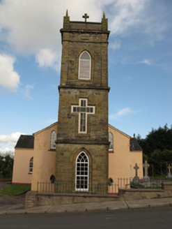 St Joesph's Roman Catholic ChurchChurch/chapel · 2.1 mi
Explorer Tom St Joesph's Roman Catholic Church in Fornaght is wearing crenellations like a castle crown, which is weird for a country church but very cool anyway. It’s got pointed arches that point at you. Nod respectfully!
Lyradane MountainMountain / peak · 2.4 miExplorer Tom Lyradane Mountain in Cork is hiding a tunnel that leads straight to the best pub in town, or so the stories go. It’s got that mysterious vibe where you swear you can hear pints clinking from inside the rocks. Hang around long enough and you'll hear a story from a local.
 Castle View HouseFarm house · 2.6 mi
Explorer Tom Castle View House is sitting empty in Garraun South with a religious tile above the door that’s definitely praying for a new owner. It’s a big farm house from the 1820s that just wants to be used again.
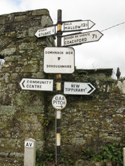 sign post2.7 mi
Explorer Tom Sign post in Lackabane is showing off its new harp haircut. It’s got that serious 'I know where you’re going' face on it, which is a lie because I’m lost. Bring a notebook to write down how smug it looks!
 LisheenbegFairy fort / earthen ringfort · 3.1 mi
Explorer Tom Lisheenbeg is a heavily overgrown circle with an entrance on the east side. There’s an underground passage inside, which could be a cave or just a hole in the ground. Don't get lost down there!
 LisheentoortaghFairy fort / earthen ringfort · 3.1 mi
Explorer Tom Lisheentoortagh is called 'Little fort of the Royal Palace' by Bowman, which is a bit grand for a ringfort. It has a proper entrance and trees planted outside. It’s trying very hard to be important.
 Castle Barrett (in Ruins)Castle, Anglo-Norman masonry castle · 5.3 mi
Explorer Tom Castle Barrett in Castlebarrett is just fragments of walls and a collapsed tower now. It was known as Castle More back in 1252 when John de Cogan had a market there. I wonder if anyone sells pies here anymore!
 Castle BarrettCastle · 5.3 mi
Explorer Tom Castle Barrett in County Cork is just the remains of a twelfth-century fortress. It's been standing around for ages, waiting for someone to notice. Take a pic for me if you spot any old stones!
 Lavitts QuayMemorial · 13 mi
Explorer Tom Lavitts Quay is a memorial where, legend has it, a goat once ruled the harbour by eating all the navigation charts before the tide came in. Now it’s just rocks and stories, but if you look closely, you can still see the hoofprints of that terrible beast. Bring your worst joke, the place has heard worse.
More archaeology and monuments in County Cork · All of County Cork

What do you know about this place?Tap to add a comment or ask a question