Places near here
Photo credits
- National Inventory of Architectural Heritage
- John M, Wikimedia Commons · CC BY-SA 2.0
- Jonathan Thacker, Geograph · Creative Commons Attribution-ShareAlike 2.0
- Ingo Mehling, Wikimedia Commons · CC BY-SA 3.0
- A.-K. D., Wikimedia Commons · CC BY-SA 4.0
- Garry Dickinson, Geograph · CC BY-SA 2.0
- Jean-Pol GRANDMONT, Wikimedia Commons · CC BY 3.0
- Draceane, Wikimedia Commons · CC BY-SA 4.0
- John M, Geograph · CC BY-SA 2.0
- Steve Edge, Geograph · CC BY-SA 2.0
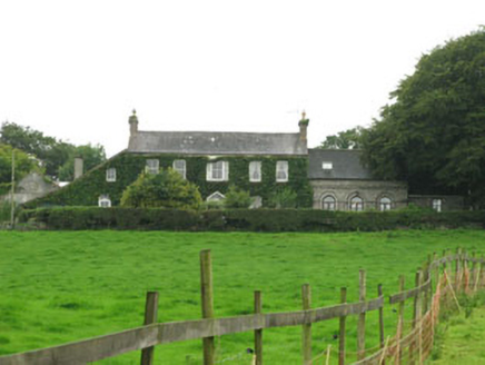 Mahon Abbey HouseCountry house · 439 yd
Explorer Tom Mahon Abbey House overlooks the ruins of Mahon Abbey, which is a bit like standing next to your own ex’s grave. It’s an eighteenth-century beauty that probably thinks it’s much better than all those crumbling stones down there. Bring a flask for the view!
 Mahon AbbeyVisitor attraction · 615 yd
Explorer Tom Mahon Abbey would survive a zombie attack by locking the doors and pretending no one is home. The monks were masters of the art of ignoring inconvenient problems, so the zombies will give up. Bring a camera and your most suspicious face.
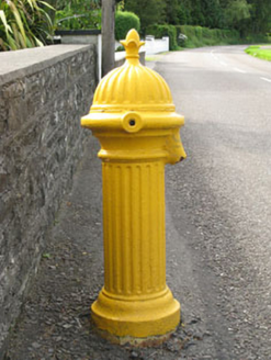 water pump735 yd
Explorer Tom Water pump in Abbeymahon is fancy street furniture that remembers when you had to actually work for a drink. It probably thinks Dublin tourists are too soft to use the handle properly. Give it a little pump and see what happens, but don't expect miracles.
 Graveyard1.1 mi
Explorer Tom Graveyard in Timoleague was used after the friary was plundered in 1612. Sean O Coileain is buried here, so you’re walking on poetry history now. The ground level is higher than original because of all the burials. Mind your step!
 Timoleague AbbeyHeritage attraction · 1.1 mi
Explorer Tom Timoleague Abbey has West Cork's riverside view and enough surviving stone to make me wonder who agreed to build so much for friars. The Franciscan ruins stand by the Argideen on ground linked with Saint Molaga, whose name lives in the town's. Much of the visible friary dates from around the fourteenth century. Look for wall passages and an outside way to an upper floor, details unusual enough to make even a confident guide pause. I would volunteer to find the secret passage, then be told it was never secret at all. The community once traded with Spain; later war and fire damaged the buildings. This is a historic ruin, so check present public access, mind uneven ground and give any fragile walls space. Walk by the river before entering. The water shows why this was a busy address, not a remote retreat.
 Timoleague FriaryVisitor information · 1.1 mi
Explorer Tom Timoleague Friary in County Cork was where a very confident monk once lost a bet about how tall he could jump, ending up in the mud for an hour. The stones still look slightly embarrassed about the whole affair and the questionable acrobatics involved. Go on, count the windows and get it wrong like I did.
 Timoleague CastleCastle, tower house · 1.2 mi
Explorer Tom Timoleague Castle is covered in ivy and only two storeys high now, but it used to be four. It got damaged by an explosion in the 1920s, which was dramatic. I bet the inscription on that transome is still readable.
 Cork oak1.9 mi
Explorer Tom Cork oak here, and it's been hit with a hammer more times than my patience on Sunday mornings. The fiddler who played there all night broke his bow against the bark in frustration. Ideal spot for a dramatic phone call about rent.
 Chilean myrtle1.9 mi
Explorer Tom This Chilean myrtle in Cork is acting like Saint Patrick personally planted it and expects a blessing. It says the saint called it 'a bit of a tourist trap' back then. Take a breath, it's older than your bad decisions.
 Grave YardGraveyard · 2.0 mi
Explorer Tom Graveyard in Lisleetemple has headstones from the late 18th century to today, sitting next to a current Church of Ireland church on the site of an older one. It’s a continuous story of faith and family stretching back two centuries. Have a wander through!
 Flaxfort StrandBeach / strand · 2.1 mi
Explorer Tom Flaxfort Strand claims Queen Victoria visited in secret just to check if the flax was still growing well, but nobody can find the diary entry to prove it was actually her. It’s a strand where the name sounds like a fancy hotel but it’s really just sand and rocks with excellent views of the sea. Best seen with a hangover and a sausage roll.
 Broad StrandBeach / strand · 2.2 mi
Explorer Tom Broad Strand was designed by a mother-in-law who wanted space for her entire extended family to spread out without touching. It’s wide enough to lose your keys in, which is why nobody ever finds them. The cliffs at the north end are just watching you struggle with the wind. Ideal stop for a big stretch and a bigger yawn.
More archaeology and monuments in County Cork · All of County Cork

What do you know about this place?Tap to add a comment or ask a question