Places near here
Photo credits
- National Inventory of Architectural Heritage
- Mike Searle, Geograph · CC BY-SA 2.0
- The Speckled Bird, Wikimedia Commons · CC BY-SA 4.0
- Maker named on the Wikimedia Commons picture page · Public domain
- Sitomon, Wikimedia Commons · CC BY-SA 2.0
- Towel401, Wikimedia Commons · CC BY-SA 4.0
- john berry, Geograph · CC BY-SA 2.0
- Robert Ashby, Geograph · CC BY-SA 2.0
Explorer Tom Glebe Island made a New Year's resolution to stop being so cold, but it forgot about it by February, like us all. It’s just out there doing its thing while the birds ignore it completely. Sit on a wall near it and pretend you’re in a painting.
 sign post1.2 mi
Explorer Tom Sign post in Gortaroo has been keeping watch since 1940 with its rectangular shape and serious expression. The harp is there to add a bit of local flavour. Check the pole, it’s probably solid as steel.
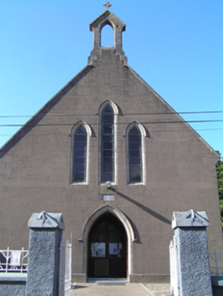 Saint Ita's Roman Catholic ChurchChurch/chapel · 1.3 mi
Explorer Tom Saint Ita's Roman Catholic Church in Gortaroo uses concrete imitative of stone, which is like wearing a disguise that everyone knows isn’t working. It has simple geometric forms and pointed arches that create a coherent whole, even if it’s a bit weird. Stop the car and look up, because you might miss the details.
Enclosure in AghavineEnclosure · 1.9 miExplorer Tom Enclosure in Aghavine shows up as parch marks, which means it’s only visible when things are dry. It might have underground passages too! That’s spooky for a field. If the ground is wet, it’s invisible. If it’s dry, look for the weird lines!
 Inchiquin Castle (in Ruins)Castle, Anglo-Norman masonry castle · 2.1 mi
Explorer Tom Inchiquin Castle is a round tower sitting right by the river. It has a wicker-centred dome that’s mostly broken. The windows are splayed out like they’re trying to see everything. Watch out for the drawbar socket; it’s higher than your feet!
 Collegiate Church of Saint MaryHeritage attraction · 3.0 mi
Explorer Tom Collegiate Church of Saint Mary in County Cork took so many cups of tea to build that the builders probably never actually finished their work. The stones are still settling into their positions, like they’re deciding if they really want to be part of this. Perfect spot to practise your best tour-guide voice.
 English holly3.0 mi
Explorer Tom Another English holly, smelling like wet cardboard and regret according to Tom's nose. It says it only grows on land that was once haunted by bad decisions. Dare you to say hello out loud, see if it flinches.
 European Yew3.0 mi
Explorer Tom European Yew in Cork says its mother-in-law designed it to be perfect, which is why it's so rigid and judgmental. She still checks up on it via the roots. Hang around long enough and you'll hear a story from a local.
 Capel IslandIslet · 3.2 mi
Explorer Tom Capel Island gave up bread for Lent, which makes sense considering how many crusty birds are constantly fighting over crumbs on its shore. You need written permission from Birdwatch Ireland to even look at it properly, so don’t be a tourist and just wander in uninvited. Ideal for a moody photo you'll pretend wasn't posed.
 Ferry PointViewpoint · 3.3 mi
Explorer Tom Ferry Point has very strong opinions about modern buildings, thinking they’re all just tall concrete blocks lacking in soul and proper maritime history. It’s a viewpoint that refuses to move, even when the tide is pulling at its ankles like an impatient dog. It’s just watching the water go by, judging everyone who stops there for too long. Linger, it's not going anywhere and neither should you.
 Kilnatoora CastleCastle, tower house · 3.7 mi
Explorer Tom Kilnatoora Castle is ivy-clad and standing next to a sheer rock face that looks scarier than the castle itself. It’s got a vaulted lobby that might eat your keys. Pretend you're a lost aristocrat, nobody will check your ID.
 Garryvoe BeachBeach / strand · 6.5 mi
Explorer Tom Garryvoe Beach acts exactly like the drunk uncle at a wedding who keeps telling stories nobody asked to hear. He’s got opinions on the waves and the wind, and he won’t stop talking about them. Ten minutes here and you'll have a yarn for the pub.
More historic places in County Cork · All of County Cork

What do you know about this place?Tap to add a comment or ask a question