
Places near here
Photo credits
- National Inventory of Architectural Heritage
- Eric Jones, Geograph · CC BY-SA 2.0
- Kenneth Allen, Geograph · Creative Commons Attribution-ShareAlike 2.0
- Kenneth Allen, Geograph · CC BY-SA 2.0
- Kenneth Allen, Wikimedia Commons · CC BY-SA 2.0
- Anne Burgess, Wikimedia Commons · CC BY-SA 2.0
- louise price, Geograph · CC BY-SA 2.0
- Ronnie Nijboer, Wikimedia Commons · CC0
- Joseph Mischyshyn, Wikimedia Commons · CC BY-SA 2.0
- Kieran Evans, Geograph · CC BY-SA 2.0
 Con's CottageHouse · 2.8 mi
Explorer Tom Con's Cottage in Derrydruel Upper, built c.1860, wears its stone and iron pegs like a safety harness for a very determined straw thatch. I imagine it holding on tight just to prove it can outlast the wind.
 Drumlaghdrid HillMountain / peak · 2.8 mi
Explorer Tom Drumlaghdrid Hill stands in County Donegal with its access details currently unknown. A photograph shows the B7905 road climbing south-eastwards across its flank, six kilometres north of Lettermacaward. It is a bit cheeky for a hill to have such a well-documented road climbing up its side while still keeping its own path a secret!
 Traighena National SchoolSchool · 3.0 mi
Explorer Tom Traighena National School has a tall tale about a hidden tunnel to the pub that runs under the T-plan and straight into the back of the local shop. It’s got oculus vents and chimneybreasts that look like they’re trying to breathe deeply after a long day of teaching. Look for the plaque if you dare.
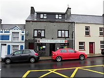 Teach Owenie BánPub · 3.4 mi
Explorer Tom Teach Owenie Bán in Dungloe has a sign that’s falling off the wall, which is very on-brand for the pub. The Irish name is fancy, but the pints are likely mediocre. Keep an eye out for ghosts.
 Mulhern’s Corner BarPub · 3.4 mi
Explorer Tom Mulhern’s Corner Bar sits right on Lower Main Street, looking down its nose at everyone else. The corner is probably sharp enough to cut your cheek. Ask if they have any stories about the wall.
 Cairn, Coolvoy, DoocharyPublicly named cairn · 3.6 mi
Explorer Tom Cairn, Coolvoy, Doochary is a name that sounds like it belongs to a place with a lot of local history and stories. I imagine it’s one of those spots where the ground has been used by people for a very long time, maybe for marking boundaries or gathering. It’s a name that makes you curious about what went on there.
 Cairn, LoughanurePublicly named cairn · 4.6 mi
Explorer Tom Cairn, Loughanure is a place where the name suggests a connection to water and perhaps a specific local story. I imagine it’s one of those spots that has been part of the landscape for a long time, maybe used by people who lived nearby. It’s a name that makes you think about how places get their names.
 CroaghnamaddyMountain / peak · 4.6 mi
Explorer Tom Craigawaddykeagh in County Donegal is showing off its name like a peacock. If it won the lotto, it’d buy a bigger hat to hide behind. The locals say it’s just a rock with an attitude problem. Stand on the spot and imagine the gossip it's heard. It’s definitely judging your shoes right now.
 DooeyOfficial bathing water · 6.0 mi
Explorer Tom Dooey seems to have let the Gweebarra estuary and a headland book its two ends. Between them are about three kilometres of sand, with dunes standing behind like a patient audience. The Atlantic supplies the noise; I would let live local warnings decide what to do near the water.
 Wych Elm7.2 mi
Explorer Tom Wych Elm claims there’s a shortcut through its branches that saves twenty minutes, but nobody has ever actually found the exit yet. People get lost in the canopy and end up climbing down on the same side they started from. It’s a bit of a trickster with a green exterior. Bring a flask of something warm and a story to swap.
 Inis Mhic an DoirnIsland · 7.6 mi
Explorer Tom Rutland Island was once pitched as the next big fishing town, and I would have invested every imaginary penny in it. William Burton Conyngham set up the planned settlement between Burtonport and Arranmore in the 1780s, renaming Inis Mhic an Doirn for the Duke of Rutland. There were streets, a customs house, barracks and a sail-and-net factory. Then the herring catches fell, the fishery failed in 1793 and dunes swallowed parts of the village. That is a spectacularly quick lesson in not promising the sea will keep an appointment. The island remained inhabited into the 1960s; houses there are now holiday homes. Arrange a permitted boat and confirm landing and return before visiting, and respect private buildings. Look at the dunes with the lost street plan in mind. Sand is a ruthless town planner.
 Braade StrandBeach / strand · 7.8 mi
Explorer Tom “Braade Strand” in County Donegal would bring a massive bucket of sand and a grumpy crab to any party, which honestly sounds like a perfect combo for most gatherings. It’s a stretch of shore where the wind is loud enough to drown out your inner critic and make you feel small and free. Practise your Irish on it, it won't correct you.
More historic places in County Donegal · All of County Donegal

What do you know about this place?Tap to add a comment or ask a question