DDiscover AloneMapAbout

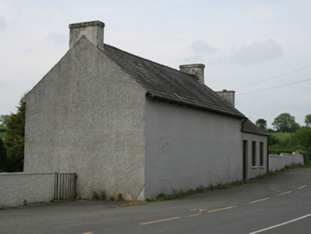
House in Lisdonny

House
House in Lisdonny
Photo: National Inventory of Architectural Heritage · Report the wrong picture

What is recorded here

Detached three-bay two-storey vernacular house, built c.1870, with single-storey ancillary farm buildings to rear (west). Now vacant. Pitched natural slate roof with red brick chimneystacks to gable ends. Carved timber bargeboards to gables, and cast-iron rainwater goods. Roughcast rendered walls, having…

Read the whole record
Detached three-bay two-storey vernacular house, built c.1870, with single-storey ancillary farm buildings to rear (west). Now vacant. Pitched natural slate roof with red brick chimneystacks to gable ends. Carved timber bargeboards to gables, and cast-iron rainwater goods. Roughcast rendered walls, having smooth-rendered plinth course and quoins. Square-headed window openings with rendered and painted reveals and painted stone sills, having six-over-six pane timber sliding sash windows to front (east) elevation. Central square-headed door opening to east elevation, having smooth rendered door surround and replacement timber panelled door. Concrete path to replacement metal gate to east, flanked by square-plan piers and low plinth wall. Single-storey and two-storey farm buildings to west, having pitched corrugated-iron and pitched slate roofs, roughcast rendered and exposed coursed rubble limestone walls, and square-headed openings with some timber battened fittings, and with one segmental-headed door opening having brick voussoirs and no remaining fittings. Located west of Castleblayney to Newtownhamilton road south-west of Oram village.
This house largely retains its original late nineteenth-century and fabric. Its setting is further enhanced by the survival of mid-nineteenth-century farm buildings to the west. The retention of timber sash windows enhances the heritage value of the building. Local vernacular materials have been used in the construction of the buildings and boundary walls. The house and associated farm buildings, while not indicated on the 1835 Ordnance Survey map or Griffith Valuation map c.1858, appear on the 1908 OS map suggesting a late nineteenth century date. The symmetrical and attractive house is a picturesque addition to this country road from Castleblayney to Newtownhamilton and retains its architectural significance.

From the Buildings of Ireland (National Inventory of Architectural Heritage) record 41402009

This does not grant access. Most recorded buildings are privately owned; view them only from public ground unless the owner allows entry.

What do you know about this place?Tap to add a comment or ask a question

What you write will be public.

Places near here

Photo credits
  • National Inventory of Architectural Heritage
  • Shane Killen, Wikimedia Commons · CC BY-SA 2.0
  • Kenneth Allen, Wikimedia Commons · CC BY-SA 2.0
  • Dean Molyneaux, Wikimedia Commons · CC BY-SA 2.0
  • Eric Jones, Geograph · CC BY-SA 2.0
  • unknown author, Wikimedia Commons · Public domain
  • Eric Jones, Geograph · Creative Commons Attribution-ShareAlike 2.0
  • Kenneth Allen, Geograph · CC BY-SA 2.0
school198 yd

Explorer Tom School in Oram took forty cups of tea to build, according to local rumour. The windows are blocked up so it looks like a shy brick box. Practise your Irish if you want to impress the ghosts inside.

hall203 ydLough MucknoLake and park landscape · 2.1 mi

Explorer Tom Lough Muckno was the original escape plan for someone who really needed a long drink by the water’s edge. It sits there judging your swimming technique from the safety of its deep, mysterious depths without ever saying a word to you. Tell your mates you found it first.

Mindszenty ParkPark · 2.1 miMullavashPassage tomb · 2.2 miMullyash MountainMountain / peak · 2.3 miBlaney CastleCastle · 2.3 miCastle BlayneyHouse, fortified house · 2.4 miCrane IslandIsland · 2.4 miCrannog in lisleitrim lough in Kiltybane or LisleitrimCrannog in Lisleitrim Lough · 3.2 mi

Explorer Tom Crannog in Lisleitrim lough in Kiltybane Or Lisleitrim is an unusually large wooded crannog, which means it’s basically a tree house for giants. The builder was probably thinking about snacks when they built this. Have a chat with it; nobody's watching from the shore.

Monaghan WayWalking route · 3.5 mi

Explorer Tom Monaghan Way is heading west like it has somewhere important to be, even though it’s just a lane towards a lough that doesn't care about you. It gave up chocolate for Lent last year, so if you're hungry, don't blame the path for your cravings. Best enjoyed with a bag of chips and no plans.

Tullyvallen Orange Hall massacreMassacre · 3.8 mi

Explorer Tom Tullyvallen Orange Hall massacre in County Armagh has a hidden message in its stones that says 'bring snacks' if you squint hard enough. Tell me if the gossip I made up is true; I’m betting it’s close.

More historic places in County Monaghan · All of County Monaghan

Add to this placeAdd a picture Add a detailed tip Add a story

Explore the map1,093,392 places to discover

Next place · or swipeschool